Watch Hurricane Erin swirl menacingly in the Atlantic Ocean in NOAA satellite video
Hurricane Erin will go down in the books as the first major hurricane of the year.
Breaking space news, the latest updates on rocket launches, skywatching events and more!
You are now subscribed
Your newsletter sign-up was successful
Want to add more newsletters?

Delivered daily
Daily Newsletter
Breaking space news, the latest updates on rocket launches, skywatching events and more!

Once a month
Watch This Space
Sign up to our monthly entertainment newsletter to keep up with all our coverage of the latest sci-fi and space movies, tv shows, games and books.

Once a week
Night Sky This Week
Discover this week's must-see night sky events, moon phases, and stunning astrophotos. Sign up for our skywatching newsletter and explore the universe with us!

Twice a month
Strange New Words
Space.com's Sci-Fi Reader's Club. Read a sci-fi short story every month and join a virtual community of fellow science fiction fans!
Hurricane Erin might not have made landfall in the United States, but it’s still been pretty impactful along the East Coast.
The storm might not be the strongest, spinning and moving to the northeast in the Atlantic Ocean and away from the United States, but it remains quite the beast in size and causing indirect impacts.
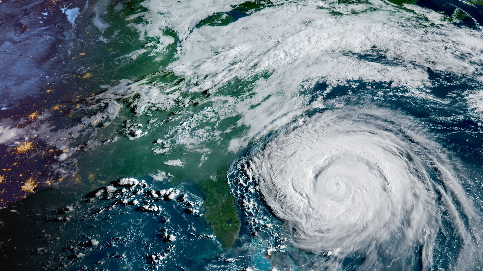
It's only the fifth named storm so far of the Atlantic hurricane season, still going down in the books as the first major hurricane of the year. In a series of videos captured by GOES-19, you can see the progression of the storm and see just how far Erin's outer bands extend.

Some ad blockers can disable our video player.
Erin formed on Aug. 11, at one point rapidly intensifying into a monster Category 5 hurricane with sustained winds of 160 mph (260 km/h).
This week, the hurricane lost its wind power, weakening to a Category Two storm on the Saffir-Simpson Hurricane Wind Scale, and taking on more non-tropical characteristics as it leaves the U.S. in its rearview mirror. However, the storm left its mark and still poses concern for some coastal communities, continuing the danger of life-threatening surf, coastal flooding, and a high rip current risk from the Carolinas all the way up into the Northeast.
From space, the National Oceanic and Atmospheric Administration's (NOAA) Geostationary Operational Environmental Satellite (GOES) satellites have been following Erin throughout its journey, helping paint a picture of the storm so we can truly understand its size and comparison to locations nearby, such as Bermuda and the coastal states.
Over time, the once symmetric and healthy-looking hurricane becomes more disorganized, losing strength and weakening in less favorable conditions.
Breaking space news, the latest updates on rocket launches, skywatching events and more!
Heading into the weekend, forecasters say as it continues to make its journey east, there will still be an on-going likelihood for hazardous conditions for the East Coast.
To stay up-to-date with the latest on Erin, you can find more details from NOAA’s National Hurricane Center.

Meredith is a regional Murrow award-winning Certified Broadcast Meteorologist and science/space correspondent. She most recently was a Freelance Meteorologist for NY 1 in New York City & the 19 First Alert Weather Team in Cleveland. A self-described "Rocket Girl," Meredith's personal and professional work has drawn recognition over the last decade, including the inaugural Valparaiso University Alumni Association First Decade Achievement Award, two special reports in News 12's Climate Special "Saving Our Shores" that won a Regional Edward R. Murrow Award, multiple Fair Media Council Folio & Press Club of Long Island awards for meteorology & reporting, and a Long Island Business News & NYC TV Week "40 Under 40" Award.
You must confirm your public display name before commenting
Please logout and then login again, you will then be prompted to enter your display name.
