


Lunar Reconnaissance Orbiter Eyes Apollo 12, Surveyor 3 Sites

This image from the Lunar Reconnaissance Orbiter shows the Apollo 12 and Surveyor 3 landing sites. This image was released July 9, 2013.
Side-By-Side of Surveyor Crater

These side-by-side images show Surveyor crater as seen by LRO (left) and Lunar Orbiter 3. The LRO image has been stretched to better match the Lunar Orbiter 3 image. This image was released July 9, 2013.
Wide Look at Apollo 12 and Surveyor 3 Landing Sites

This is a wider image of the Apollo 12 and Surveyor 3 landing sites from LROC's Wide Angle Camera. The bright rays of Copernicus crater were formed from material ejected by the impact that created the crater. This image was released July 9, 2013.
Apollo 11 Moon Landing Site Seen by Lunar Reconnaissance Orbiter
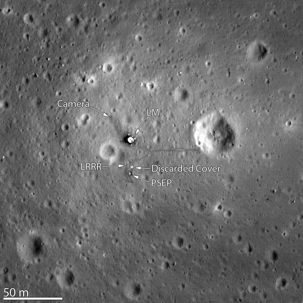
The Lunar Reconnaissance Orbiter Camera snapped its best look yet of the Apollo 11 landing site on the moon. The image, which was released on March 7, 2012, even shows the remnants of Neil Armstrong and Buzz Aldrin's historic first steps on the surface around the Lunar Module.
New Photos Reveal Apollo 11 at First Moon Landing Site

In this image, the Apollo 11 lunar lander and it shadow can be seen in a view from NASA's new Lunar Reconnaissance Orbiter, which is scouting the moon for new landing sites for future astronauts.
Weird Moon Crater May Be Crash Site of Old NASA Spacecraft

An odd-looking impact feature on the lunar surface that was seen by the Lunar Reconnaissance Orbiter Camera (LROC).
New Moon Photo Reveals Tracks from Tough Apollo Moonwalk

This annotated figure shows the positions of various landmarks surrounding the Apollo 14 landing site on the moon's Fra Mauro highlands as seen by the LRO spacecraft. The small white arrows highlight locations where the astronauts' path can be clearly seen.
Apollo 12 Landing Site

The tracks made in 1969 by astronauts Pete Conrad and Alan Bean, the third and fourth humans to walk on the moon, can be seen in this LRO image of the Apollo 12 site. The location of the descent stage for Apollo 12's lunar module, Intrepid, also can be seen.
Apollo 14 Landing Site

The paths left by astronauts Alan Shepard and Edgar Mitchell on both Apollo 14 moon walks are visible in this LRO image. (At the end of the second moon walk, Shepard famously hit two golf balls.) The descent stage of the lunar module Antares is also visible.
Apollo 15: The High View

The Apollo 15 Lunar Module (LM) Falcon set down on the Hadley plains a mere 2 kilometers from Hadley Rille as seen by NASA's Lunar Reconnaissance Orbiter. This image was released on March 7, 2012.
Apollo 15 landed on the moon in July 1971.The goals: sample the basalts that compose the mare deposit, explore a lunar rille for the first time, and search for ancient crustal rocks. Additionally, Dave Scott and Jim Irwin deployed the third Apollo Lunar Surface Experiments Package (ALSEP) and unveiled the first Lunar Roving Vehicle (LRV). The ALSEP consisted of several experiments that were powered by a Radioisotope Thermoelectric Generator (RTG) and sent back valuable scientific data to the Earth for over six years after the astronauts left.
This new LROC NAC image taken from low altitude shows the hardware and tracks in even more detail.
Apollo 16: Moon's North Ray Crater

This photo shows the Apollo 16 landing site on the southeastern rim of North Ray crater, explored by Apollo 16 astronauts John Young and Charlie Duke, revealed in a new low-altitude image by the Lunar Reconnaissance Orbiter released on March 8, 2012. Area shown is 300 meters wide,o black arrows show foot tracks. The Apollo 16 mission landed on the moon on April 21, 1972.
