Editor's Note: This article was originally presented by the Mars Odyssey's Thermal Emission Imaging System (THEMIS) team at Arizona State University. It is reproduced here with permission. At the THEMIS site, you can zoom in on this new image.
In early 2004, NASA's Mars strategy of "following the water" paid off handsomely for the rover named Opportunity. Landing in Meridiani Planum, Opportunity immediately found beds of soft sandstones, much altered by acidic water long ago.
NASA's next Mars rover will be the Mars Science Laboratory (MSL), due for launch in 2009. In hopes of hitting paydirt once again, NASA has scientists scouting for landing sites that might extend the Martian water story beyond Opportunity's glimpse at Meridiani.
Roughly 2,100 kilometers (1,300 miles) southwest of Meridiani lies Holden Crater, 154 km (96 mi) wide. Holden and surroundings contain two potential sites where MSL could study ancient water-flow deposits.
Holden's wide floor, shown in a newly released image, has abundant layered sediments, channels, and large piles of debris at canyon mouths. These suggest a long history of deposits by water. And in Eberswalde Crater, just north of Holden, scientists have spotted what is surely the remnant of a river delta.
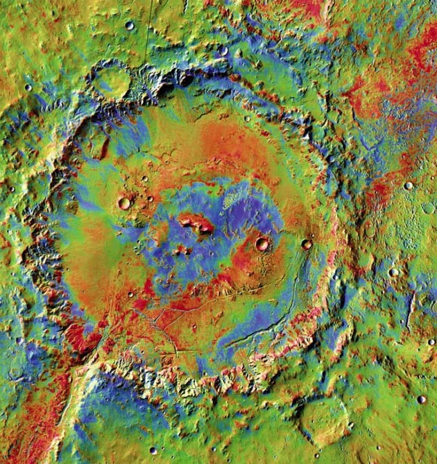
This striking view, combining images taken by day and night at infrared wavelengths, uses false colors to show the nature of the surface materials. It was taken by the Thermal Emission Imaging System (THEMIS), a multi-color camera on NASA's Mars Odyssey orbiter.
In the image, areas with high abundances of rocks and hardened deposits show up in reddish tints, while areas covered with sand, loose dirt, and fine dust appear in blue colors. Areas with a mixture of these extremes display yellows and greens.
Happy landings
Holden shows an interesting variety of surface materials. Yet it would be just another large crater if it had not formed (by asteroid impact) on what may be the longest watercourse on Mars, the Uzboi-Ladon-Margaritifer channel system. This is a series of connected valleys that stretches from the rim of the Argyre impact basin in the southern highlands thousands of kilometers north to Chryse Planitia on the northern plains.
Uzboi Vallis breaks Holden's rim in its southwest quadrant, where water flowing through the valley dumped layered sediments on the floor. As scientists reconstruct it, after the Holden impact, water flowing down Uzboi cut through the rim and spilled into the crater, depositing sediments on its floor [Image].
Planning for MSL, some scientists are studying a site where Uzboi broke through the crater's rim and left layered deposits that have partly eroded. The scientists hope to land MSL close by, on the smooth, low-gradient slope (an alluvial fan, in geo-jargon) that lies just northwest of the layered sediments. After setting down, MSL would drive over to the layered deposits and explore them.
As a candidate site, the fan has lots to offer. It's big enough to aim for, flat enough to pose little risk, not too rocky or dusty, and it's within driving distance of the layered sediments. The fan itself might have some geological interest because it undoubtedly contains rocks that eroded from the rim, which is far too rough and steep for any rover to tackle. Also, studies of the rocks may tell about how much water carried them down from the rim.
Running on electricity from a powerful nuclear-isotope generator (and not dust-vulnerable solar panels), MSL will have a minimum driving range of 20 km (12 miles) and likely can travel much farther. For comparison, Opportunity and Spirit have so far driven about 8 km (5 mi) each, but were designed to cover just 600 meters (2,000 feet).
But despite being more powerful and capable, MSL will follow the pattern established by previous Mars rovers as it seeks a balance between scientific goals and engineering risk.
Safety constraints will probably always force flight controllers to set Mars landers down at "airports" - smooth areas relatively free of deep dust and large rocks. But such sites, almost by definition, are fairly dull scientifically.
The key, say scientists and engineers, is the ability to drive away from the airport - in other words, to find flat, smooth areas with sites of geological interest nearby.
Down In the delta
In Eberswalde Crater, just north of Holden, scientists have spotted a geologically fascinating site - but whether it's trafficable by MSL remains to be decided.
Eberswalde is about 65 km (40 mi) wide and is much older than Holden. Scientists think it's likely that pieces of debris from the Holden impact lie everywhere in Eberswalde, thus going there with MSL might give scientists two craters in one.
But it's not Holden's ejecta that draws scientific interest to Eberswalde - it's the curious feature on the crater's western floor. Shaped like a head of broccoli, this is almost certainly the remains of a river delta.
The Eberswalde delta displays layered sediments, meandering channels, inverted channels, meander cutoffs, and crosscutting channels - closely resembling what happens on Earth when a river with a winding channel empties into a body of standing water. It's a smaller version of what rivers like the Mississippi (in its natural state) build at their mouths.
Even better, the delta (which actually looks like one delta partly covering another) grew from streams flowing into Eberswalde through its western rim. The delta deposits thus likely contain rock samples and sediments from a large drainage area to the west of Eberswalde.
The tricky part? Getting MSL down in one piece. There's no "local airport" here - no 20-kilometer-wide circle smooth enough to land on - nor are there any within reasonable driving range, although scientists are studying the area for a safe landing site.
Take a peak?
In the center of Holden stands a small range of hills. Central peaks like these are a common feature of craters larger than a dozen kilometers across. The peaks are made of rocks from deep below the crater site that were dragged up by the impact force. They offer scientists a look at rocks that would otherwise be hidden - which might make them a good target for MSL.
The central peaks are surrounded by merging alluvial fans, so the slopes are probably not too steep for the new rover. But the reddish color suggests the slopes have a lot of bare rock exposed, which would probably take the form of boulders. MSL can straddle rocks half a meter high (20 inches). But if it encounters ones bigger than that, it has to drive around them - provided they are not so numerous that it can't.
Yet MSL might not even get close to the central peaks. In the image, they rise out of a sea of blue, which indicates the ground around them is largely covered in fine sand or dust. Even given its more powerful motors, MSL could find itself literally spinning its wheels in a field of dunes.
- VIDEO: All Eyes on Mars
- Mars Science Laboratory: Big Wheels on A Red Planet
- IMAGE GALLERY: Visualizations of Mars
- WALLPAPER: Mars Art for Your Desktop