NASA satellites spot brand-new island in Alaska formed by melting glacier (photos)
Satellite images reveal a new island in Alaska's Alsek Lake, formed as retreating glaciers reshape the landscape.
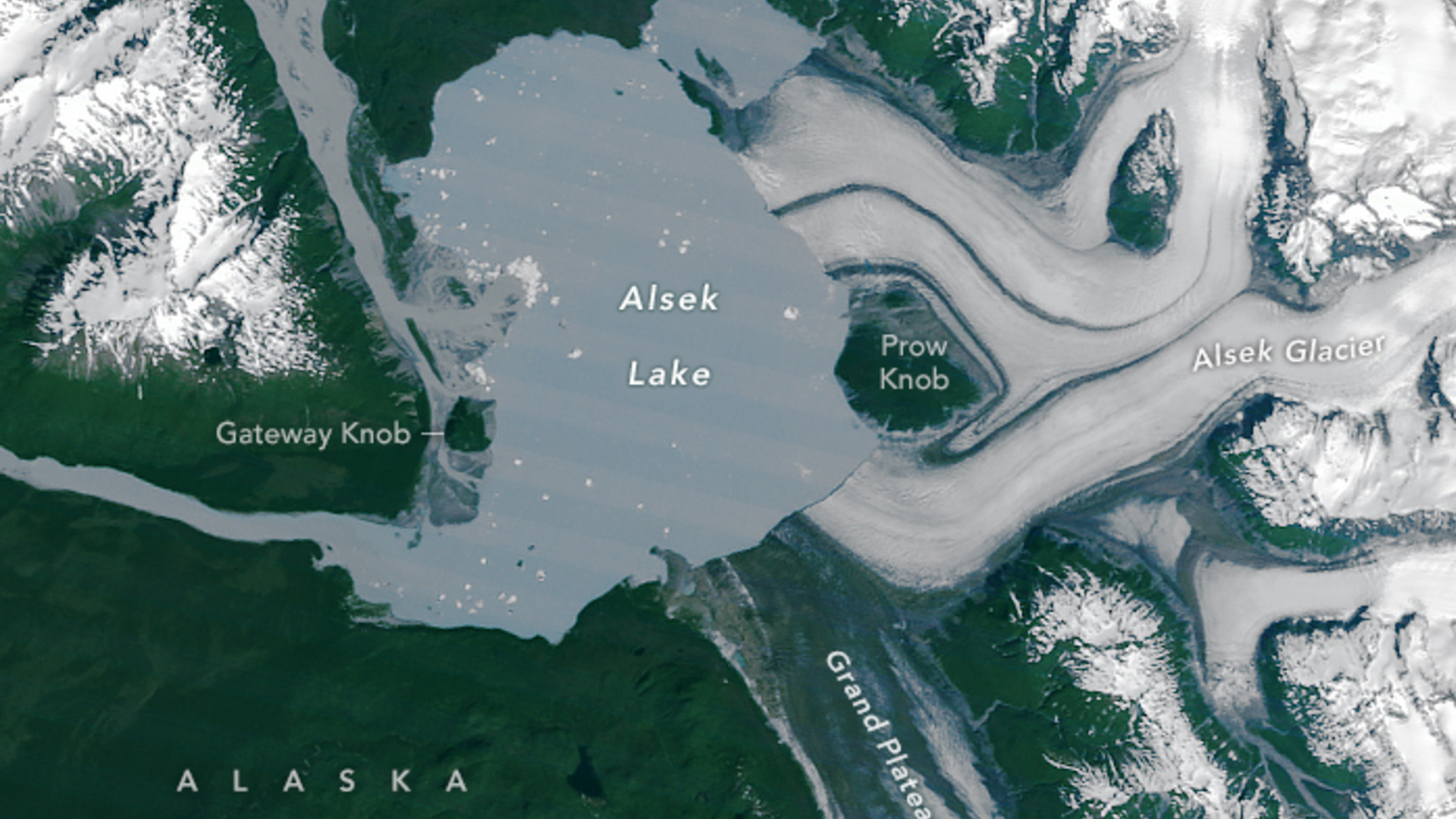
NASA satellite imagery has revealed a new island off Alaska's coast that emerged after long-standing glacial ice melted, isolating a small mountain that was once part of the mainland.
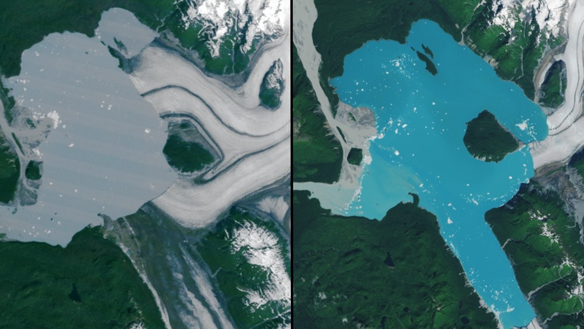
The island sits in Alsek Lake, where the Alsek Glacier has been steadily thinning and flooding the region with meltwater. Two Landsat images — captured on July 5, 1984 by the TM (Thematic Mapper) on Landsat 5 and on Aug. 6, 2025 by the OLI-2 (Operational Land Imager-2) on Landsat 9 — show the transformation in striking detail, according to a statement from NASA.
Alsek Glacier once wrapped around a small mountain known as Prow Knob. Over the past four decades, both arms of the glacier have retreated more than 3 miles (5 kilometers), carving out a proglacial lake in the process. The recent imagery confirms the glacier has now completely separated from Prow Knob, which is surrounded by water and officially an island, according to the statement.
Glaciologists have been monitoring Alsek Glacier for decades. In the early 20th century, the glacier is believed to have terminated at Gateway Knob, about 3 miles (5 kilometers) west of Prow Knob on the opposite side of what is now Alsek Lake. Since then, the glacier has continued its steady retreat, with satellite data tracking its transformation.

The retreating glacier has fueled massive lake expansion. Alsek Lake has grown from roughly 17 square miles (45 square km) in 1984 to about 29 square miles (75 km²) today. Its growth is fed not only by Alsek Glacier's meltwater but also by nearby proglacial lakes such as Harlequin and Grand Plateau. In fact, Alsek Glacier remained connected with the northern arm of the Grand Plateau Glacier until around 1999, when both ice masses had receded further, creating a major branch of Alsek Lake seen in later satellite images.
The newly emerged island measures about 2 square miles (or 5 square km). Based on satellite imagery, scientists believe it formed sometime between July 13 and Aug. 6, 2025. With the separation of Prow Knob, the glacier is now less stable and more prone to calving, when large chunks of ice break off into the lake, according to the statement.
The emergence of this island reflects the accelerating pace of glacial retreat in Southeast Alaska and its ability to reshape landscapes within decades. Expanding lakes, unstable ice fronts and newly exposed terrain point to significant shifts underway, with researchers warning that continued ice loss in a warming world could alter the region's hydrology and ecosystems.
Breaking space news, the latest updates on rocket launches, skywatching events and more!

Samantha Mathewson joined Space.com as an intern in the summer of 2016. She received a B.A. in Journalism and Environmental Science at the University of New Haven, in Connecticut. Previously, her work has been published in Nature World News. When not writing or reading about science, Samantha enjoys traveling to new places and taking photos! You can follow her on Twitter @Sam_Ashley13.
You must confirm your public display name before commenting
Please logout and then login again, you will then be prompted to enter your display name.

