How satellites helped 345,000 people track Nancy Pelosi's historic flight into Taiwan
The real-time track of Pelosi's flight was made possible by a system known as Automatic Dependent Surveillance–Broadcast, or ADS-B.

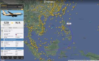
Hundreds of thousands of people used flight-tracking websites to follow the path of House Speaker Nancy Pelosi's historic flight into Taiwan on Tuesday (Aug. 2).
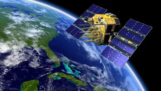
The real-time track of Pelosi's flight was made possible by a system known as Automatic Dependent Surveillance–Broadcast, or ADS-B, which uses precise tracking enabled by Global Positioning System satellites to provide accurate situational awareness to air traffic controllers.
Much of the ADS-B system relies on next-generation Iridium communication satellites, according to a statement from Aireon, a provider of space-based air traffic control services.
Related: SpaceX's Starlink broadband satellites could be used for GPS navigation
At one point when Pelosi's flight was beginning its descent into Taiwan, popular flight-tracking website FlightRadar24 (FR24) showed over 345,000 people watching the path of SPAR19, the call sign given to the U.S. Air Force Boeing C-40C transport aircraft on which she flew.
Many users were unable to access the site at the time due to what FR24 called "unprecedented sustained tracking interest," according to a statement released on Twitter.

Prior to the introduction of satellite-based ADS-B air traffic monitoring by the European Space Agency (ESA) in 2013, controllers and aviators relied on radar and short-range radio navigational aids. These ground-based systems do not offer the precision of satellite-based systems, and can be limited in range or blocked by terrain.
Get the Space.com Newsletter
Breaking space news, the latest updates on rocket launches, skywatching events and more!
According to the U.S. Federal Aviation Administration (FAA), the more precise location data facilitated by satellite-based navigation systems such as GPS enables more efficient and safer flights.
"The improved accuracy, integrity and reliability of satellite signals over radar means controllers will be able to safely reduce the minimum separation distance between aircraft and increase capacity in the nation's skies," according to an FAA statement.
"ADS-B also provides greater coverage since ground stations are so much easier to place than radar," the statement adds. "Remote areas without radar coverage, like the Gulf of Mexico and much of Alaska, now have surveillance with ADS-B."
Pelosi departed Taiwan on Wednesday (Aug. 3) after meeting with the nation's president and other high-ranking officials. The house speaker's outgoing flight did not draw nearly as much attention as her arrival, during which Chinese military aircraft flew aggressively close to Taiwanese airspace.
Follow Brett on Twitter at @bretttingley. Follow us on Twitter @Spacedotcom or on Facebook.
Join our Space Forums to keep talking space on the latest missions, night sky and more! And if you have a news tip, correction or comment, let us know at: community@space.com.

Brett is curious about emerging aerospace technologies, alternative launch concepts, military space developments and uncrewed aircraft systems. Brett's work has appeared on Scientific American, The War Zone, Popular Science, the History Channel, Science Discovery and more. Brett has English degrees from Clemson University and the University of North Carolina at Charlotte. In his free time, Brett enjoys skywatching throughout the dark skies of the Appalachian mountains.
