China Launches Navigation Satellites Into Orbit

Beidou Satellite Launch September 18, 2012
China launched a Long March 3B rocket carrying two new Beidou navigation satellites for the country's global positioning satellite constellation on Tuesday, Sept. Sept 18, 2012, from the Xichang Space Center. (Image credit: China Beidou Satellite System)

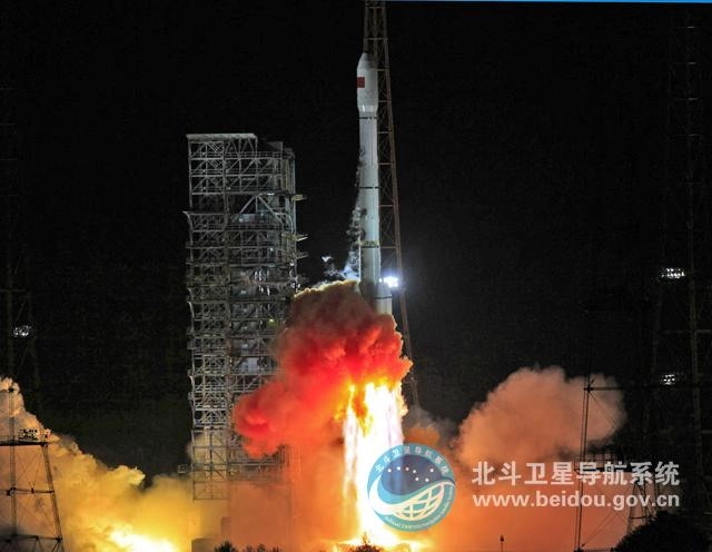
Two satellites for China's Beidou navigation system lifted off on top of a Long March rocket Tuesday (Sept. 18), adding new spacecraft to the growing network to provide more accurate positioning services to military and civil users.

The satellites launched on a Long March 3B rocketat 1910 GMT (3:10 p.m. EDT) from the Xichang space center, a facility in Sichuan province in southwest China, according to a release from the China Academy of Launch Vehicle Technology, the state-owned contractor for Chinese rockets.

Liftoff was at 3:10 a.m. Beijing time.

The 187-foot-tall rocket targeted an orbit with altitudes between 150 miles and 13,000 miles, and an inclination of 55 degrees to the equator.

Chinese government agencies declared the launch a success, marking China's 12th space launchof the year and the 50th mission worldwide to reach orbit in 2012.

Each spacecraft has on-board thrusters to raise its orbit and reach a circular altitude of about 21,500 kilometers, or 13,359 miles.

The satellites launched Tuesday are the 14th and 15th Beidou spacecraftin the program.

One more Beidou satellite is scheduled to launch into geosynchronous orbit before the end of 2012 to complete a regional network with navigation services to China and neighboring countries.

The Beidou constellation, also known as Compass, is China's counterpart to the U.S. Air Force's Global Positioning System, which provides navigation services to military vehicles, precision munitions, civil aviation, personal cars, boats, and search-and-rescue forces.

Now in operational testing for users across China, the Beidou system will provide global coverage with a constellation of 35 satellites by 2020, according to Chinese officials.

The system has been used in transportation, weather forecasting, marine fisheries, hydrological monitoring, and mapping, according to the state-run Xinhua news agency.

The best service will be available to Chinese military and civil government users. Positioning information with an accuracy of 10 meters, or about 33 feet, will be released to the public worldwide.

Copyright 2012 SpaceflightNow.com, all rights reserved.

Join our Space Forums to keep talking space on the latest missions, night sky and more! And if you have a news tip, correction or comment, let us know at: community@space.com.

Spaceflightnow.com Editor

Stephen Clark is the Editor of Spaceflight Now, a web-based publication dedicated to covering rocket launches, human spaceflight and exploration. He joined the Spaceflight Now team in 2009 and previously wrote as a senior reporter with the Daily Texan. You can follow Stephen's latest project at SpaceflightNow.com and on Twitter.