Asteroid that killed the dinosaurs also triggered global tsunami
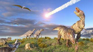
The asteroid that struck Earth 66 million years ago, wiping out three-quarters of the planet's plant and animal life (most famously the dinosaurs), also triggered a worldwide tsunami with mile-high waves.
A new study led by University of Michigan scientists reveals that this tsunami scoured the ocean floor and left geologic traces as far away as New Zealand — thousands of miles away from the impact site off what's now Mexico's Yucatan Peninsula. The findings come from the first simulation that models the global effects of the impact of the massive asteroid — named the Chicxulub impactor — upon Earth to reach publication.
The team took findings from previous research and modeled the asteroid as an 8.7-mile-wide (14 kilometers) body traveling at 27,000 mph (43,000 kph).
Related: 10 Earth impact craters you must see

The researchers supported the computer modeling by investigating the geological record at 100 sites across the globe. In particular, the scientists looked at "boundary sections," which are marine sediments laid down just before and just after the Chicxulub impact and the mass extinction that ended the era of our planet called the Cretaceous period. This investigation supported the predictions the model had made regarding the path and power of the Chicxulub-generated tsunami.
"This tsunami was strong enough to disturb and erode sediments in ocean basins halfway around the globe, leaving either a gap in the sedimentary records or a jumble of older sediments," Molly Range, who was a graduate student at the University of Michigan when the research was conducted and is the lead author, said in a statement. "The distribution of the erosion and hiatuses that we observed in the uppermost Cretaceous marine sediments is consistent with our model results, which gives us more confidence in the model predictions."
Some of the most significant geological evidence found by the team was located 7,500 miles (12,000 km) away from the Chicxulub crater on the eastern shores of islands to the north and south of New Zealand. Here the scientists found heavily disturbed sediments called olistostromal deposits that were previously believed to be the result of local tectonic activity.
Get the Space.com Newsletter
Breaking space news, the latest updates on rocket launches, skywatching events and more!
Range and her colleagues found, however, that the age and location of these deposits put them directly in the path the team modeled for the Chicxulub-triggered tsunami.
"We feel these deposits are recording the effects of the impact tsunami, and this is perhaps the most telling confirmation of the global significance of this event," Range said.
The team calculated the initial energy of the impact tsunami, finding that it was as much as 30,000 times greater than the energy of the 2004 tsunami generated by an Indian Ocean earthquake. The event, one of the largest tsunamis in modern history, killed more than 230,000 people.

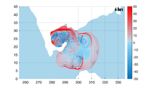
The simulation showed that the Chicxulub-triggered tsunami would have radiated to the east and northeast into the North Atlantic and to the southwest, through the Central American Seaway that at the time separated North America and South America and then into the South Pacific Ocean.
Some of the tsunami's most devastating effects occurred deep beneath the ocean's surface, with the team estimating that underwater currents in these and adjacent areas reached speeds as high as around 0.4 mph (0.6 kph).
Other areas, such as the South Atlantic, the North Pacific, the Indian Ocean and the region that is today the Mediterranean, were spared the most devastating effects of the tsunami according to the new simulation.
Building a timeline of a prehistoric disaster
The team used a two-stage strategy to model the progress of the asteroid impact and the subsequent tsunami it triggered.
The first step was to model the chaos that was the first 10 minutes of the Chicxulub impactor strike, including the formation of the crater and the beginning of the tsunami. This modeling revealed that the impactor hit granite-rich crust covered by thick sediments and shallow water, carving out a crater that was an estimated 60 miles (100 km) wide while ejecting dense clouds of dust and soot into Earth's atmosphere.
Around 2.5 minutes after the strike, the simulation indicates that displaced material would have pushed a wall of water out from the impact site, creating a wave nearly 3 miles high (5 km), which would have settled down as material began to fall back to Earth.
At 10 minutes after impact, tsunami waves nearly a mile tall would have traveled around 140 miles (220 km) from the impact site, propagating outward in a ring-like shape and sweeping across the oceans in all directions.
After 10 minutes, the team's simulation splits into two models that calculated how the giant waves traveled further outward; one of these was the model used by the National Oceanic and Atmospheric Administration (NOAA) to generate tsunami forecasts.
"The big result here is that two global models with differing formulations gave almost identical results, and the geologic data on complete and incomplete sections are consistent with those results," Ted Moore, a paleoceanographer at the University of Michigan, said in the same statement. "The models and the verification data match nicely."
From here the team modeled the further progress of the prehistoric disaster. Within an hour of impact, the tsunami had spread outside the Gulf of Mexico and into the North Atlantic; by four hours following the event, the waves had passed through the Central American Seaway and into the Pacific.

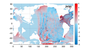
The simulation showed that 24 hours after the Chicxulub impactor had struck Earth, waves it launched had traveled almost the full extent of the Pacific and Atlantic Oceans and had just entered the Indian Ocean from both sides.
Two days after the impact, tsunami waves had hit most of the world's coastlines. The team didn't estimate how much flooding these tsunami waves would have caused, but they did calculate wave heights in the majorly impacted regions. The simulations indicated that waves in the open ocean of the Gulf of Mexico would have been over 330 feet (100 meters) high.
Meanwhile, waves in North Atlantic coastal regions and parts of South America's Pacific coast would have been 10 times smaller, at around 33 feet (10 m) high. As the tsunami waves approached shorelines in these regions and hit shallow waters, however, they would have soared dramatically in height again.
"Depending on the geometries of the coast and the advancing waves, most coastal regions would be inundated and eroded to some extent," the authors wrote. "Any historically documented tsunamis pale in comparison with such global impact."
The team's research is set to be published on Tuesday, (Oct. 4) in the journal AGU Advances.
Follow us on Twitter @Spacedotcom and on Facebook.
Join our Space Forums to keep talking space on the latest missions, night sky and more! And if you have a news tip, correction or comment, let us know at: community@space.com.

Robert Lea is a science journalist in the U.K. whose articles have been published in Physics World, New Scientist, Astronomy Magazine, All About Space, Newsweek and ZME Science. He also writes about science communication for Elsevier and the European Journal of Physics. Rob holds a bachelor of science degree in physics and astronomy from the U.K.’s Open University. Follow him on Twitter @sciencef1rst.
