Shoreline Spotted on Saturn's Moon Titan

The idea of a large sea on Saturn's moon Titan was all but ruled out after the Cassini mission found no evidence early in its mission.
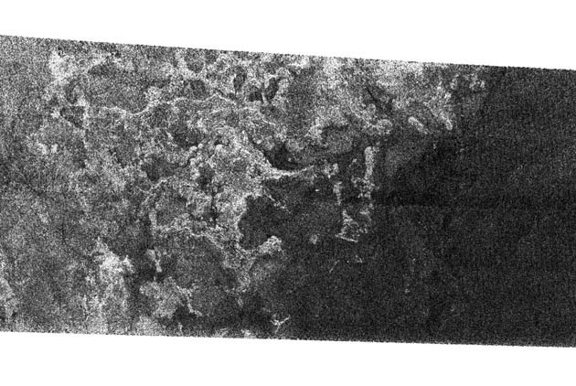
But a new image shows what scientists think is a shoreline with bays and channels feeding liquid into a possible sea.
Scientists have long speculated that Titan might contain liquid methane or other hydrocarbons. The chemistry resembles prebiotic Earth, but Titan lacks liquid water. Nonetheless, earlier this month another group of researchers speculated that Titan might actually harbor life today.
"This radar data is among the most telling evidence so far for a shoreline," said Steve Wall, radar deputy team leader from NASA's Jet Propulsion Laboratory, Pasadena, Calif.
The image, released Friday, shows a distinct division between a bright and apparently rough region and and dark and smooth area.
"This is the area where liquid or a wet surface has most likely been present, now or in the recent past," Wall said. "Titan probably has episodic periods of rainfall or massive seepages of liquid from the ground."
"We also see a network of channels that run across the bright terrain, indicating that fluids, probably liquid hydrocarbons, have flowed across this region," said Dr. Ellen Stofan, Cassini associate radar team member from Proxemy Research in Laytonsville, Md.
Breaking space news, the latest updates on rocket launches, skywatching events and more!
Combined with other radar images taken on previous Cassini passes of Titan, scientists have identified two distinct types of drainage features. One type is long and deep, suggesting fluids flowing over long distances. Another is in a denser network that suggests rainfall.
"It looks as though fluid flowed in these channels, cutting deeply into the icy crust of Titan," said Larry Soderblom with the U.S. Geological Survey in Flagstaff, Ariz. "Some of the channels extend over 100 kilometers [60 miles]. Some of them may have been fed by springs, while others are more complicated networks that were likely filled by rainfall."
More imaging is planned on future passes by the icy moon.
- Scientists Reconsider Habitability of Saturn's Moon Titan
- A Tour of Titan

Rob has been producing internet content since the mid-1990s. He was a writer, editor and Director of Site Operations at Space.com starting in 1999. He served as Managing Editor of LiveScience since its launch in 2004. He then oversaw news operations for the Space.com's then-parent company TechMediaNetwork's growing suite of technology, science and business news sites. Prior to joining the company, Rob was an editor at The Star-Ledger in New Jersey. He has a journalism degree from Humboldt State University in California, is an author and also writes for Medium.
