Afirst-class, four-ton Earth remote sensing satellite was orbited by Japan Monday,setting off on a mission to help cartographers create more precise maps on aglobal scale, scientists in their search for natural resources and officials inresponse to disasters.
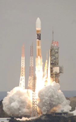
The Advanced LandObservation Satellite was launched into space by an H-2A rocket that came tolife with a thunderous roar before climbing into cloud-filled skies above theYoshinobu complex on Tanegashima Island in the southern part of Japan. Liftoffof the 174-foot tall booster was on time at 0133 GMT (8:33 p.m. EST Monday), orin the mid-morning hours at the launch site.
Fitted with two large solidrocket boosters and a pair of smaller strap-on motors, the H-2A launcherquickly sped away from Tanegashima on a southerly ground track. After a flightof 16 minutes and 30 seconds, the H-2A second stage deployed ALOS into theplanned Sun-synchronous orbit with an altitude of around 430 miles aboveIndonesia's eastern islands.
On-board cameras providedstunning video of the four strap-on boosters separating from the rocket's mainstage, and later the second stage releasing the ALOS spacecraft.
For the first time, therocket's main stage LE-7A cryogenic engine sported an extended cooling nozzlethat increases both thrust and efficiency to loft larger payloads. Insulationwas also added to the nozzle to test the material before it is incorporatedinto more powerful versions of the country's leading launcher in the nearfuture.
Five minutes afterspacecraft separation, ALOS began to unfurl its 72-foot solar array -- thelargest in Japanese space history -- that will provide electrical power to thecraft throughout its mission. Six cameras are on-board to visually verify thecorrect deployment of the solar panel and various instrument antennas.
Today's flight had beenpostponed since last summer after engineers discovered transistors on anothersatellite being readied to launch contained foreign object debris, causing theunits to work improperly. Officials checked a host of other satellites still onthe ground for similar problems, and they noted that ALOS relied on similartransistors produced by the same company near the same time as those aboard theASTRO-F infrared telescope. As a precaution, workers replaced the transistorson ALOS, delaying the launch until early this year.
A subsequent issue croppedup Wednesday concerning one of three telemetry transmitters on the H-2A rocket,and managers ordered a swap out of the suspect component. The vehicle wasrolled to the pad from its nearby assembly hangar late Sunday, local time, inthe final hours before a Monday morning launch attempt. However, Monday's trywas scrubbed before sunrise to allow engineers time to troubleshoot an issuewith ground equipment responsible for monitoring conditions inside theultra-clean payload shroud.
Keeping with Japanese spacetradition, ALOS carries a nickname -- "Daichi," which translates to"land" in English.
The craft is a key memberof Japan's Earth observation fleet, and is one of the largest satellites eversent into space in that nation's history. Weighing in at well over 8,000 poundsat launch, ALOS is designed to operate for at least three years, with a programobjective for a mission lasting up to five years.
Japan's environmentalsatellite program has a past dotted with missions having premature endings,including the loss of two spacecraft tasked with tracking global warming andclimate change.
Officials hope to put thatkarma to rest with ALOS, which will alone obtain data to compose worldwide mapson a 25,000 to 1 scale, but with special emphasis on the Asia-Pacific region.The satellite will use technology and instruments derived from those includedon earlier missions such as the Japan Earth Resources Satellite and theAdvanced Earth Observation Satellite project.
The PanchromaticRemote-sensing Instrument of Stereo Mapping, or PRISM, payload will take imageswith a resolution as high as eight feet in black-and-white. The optical cameraconsists of three sensors pointing forward, down, and backward along thecraft's ground track as it orbits Earth. This feature allows the instrument togather quality three-dimensional data in individual swaths over 20 miles widefor scientists and map-makers to use in their topographic maps.
Also aboard ALOS is theAdvanced Visible and Near Infrared Radiometer-2 (AVNIR-2), which is derivedfrom its namesake that flew on the ADEOS satellite in 1996. The device can panacross the flight path of the spacecraft at angles of up to 44 degrees, andwill use this ability to help sense vegetation and plant types. Thisinformation will be compiled into land usage maps.
The third instrumentincluded on the satellite is the Phased Array L-band Synthetic Aperture Radar,or PALSAR. This payload is an upgrade of a similar radar system that was aboardthe JERS-1 platform that was launched in 1992. PALSAR will send radar beamstoward Earth from space, and will analyze the pulses as they are bounced offthe surface back to a receiver. This capability enables all-weatherobservations that can conducted around the clock.
Fully developed by theJapanese Aerospace Exploration Agency, ALOS is expected to contribute toresponse efforts during natural disasters and other emergencies due to thesatellite's ability to produce detailed images within two days of an event.Regional observations will focus on land usage, crops, forests, and floatingice.
The next H-2A launch isjust under a month away on February 15, when the multi-functional MTSAT-2satellite will be launched on a dual mission to improve air traffic congestionin the Far East and to deliver regional weather data to forecasters. Thatflight will use the same model of the H-2A rocket as ALOS, and both vehicleswere integrated in parallel using two mobile launch tables.
Other H-2A missions on thebooks in the coming year include the launch of a pair of Japanese government spysatellites by next March. The manifest also includes the oft-delayed mission tocarry the ETS-8 communications and engineering test satellite to space.