How to read and understand a solar eclipse map
To witness a spectacular solar eclipse you need to be in the right place at the right time. Here's some guidance on how to interpret solar eclipse maps.
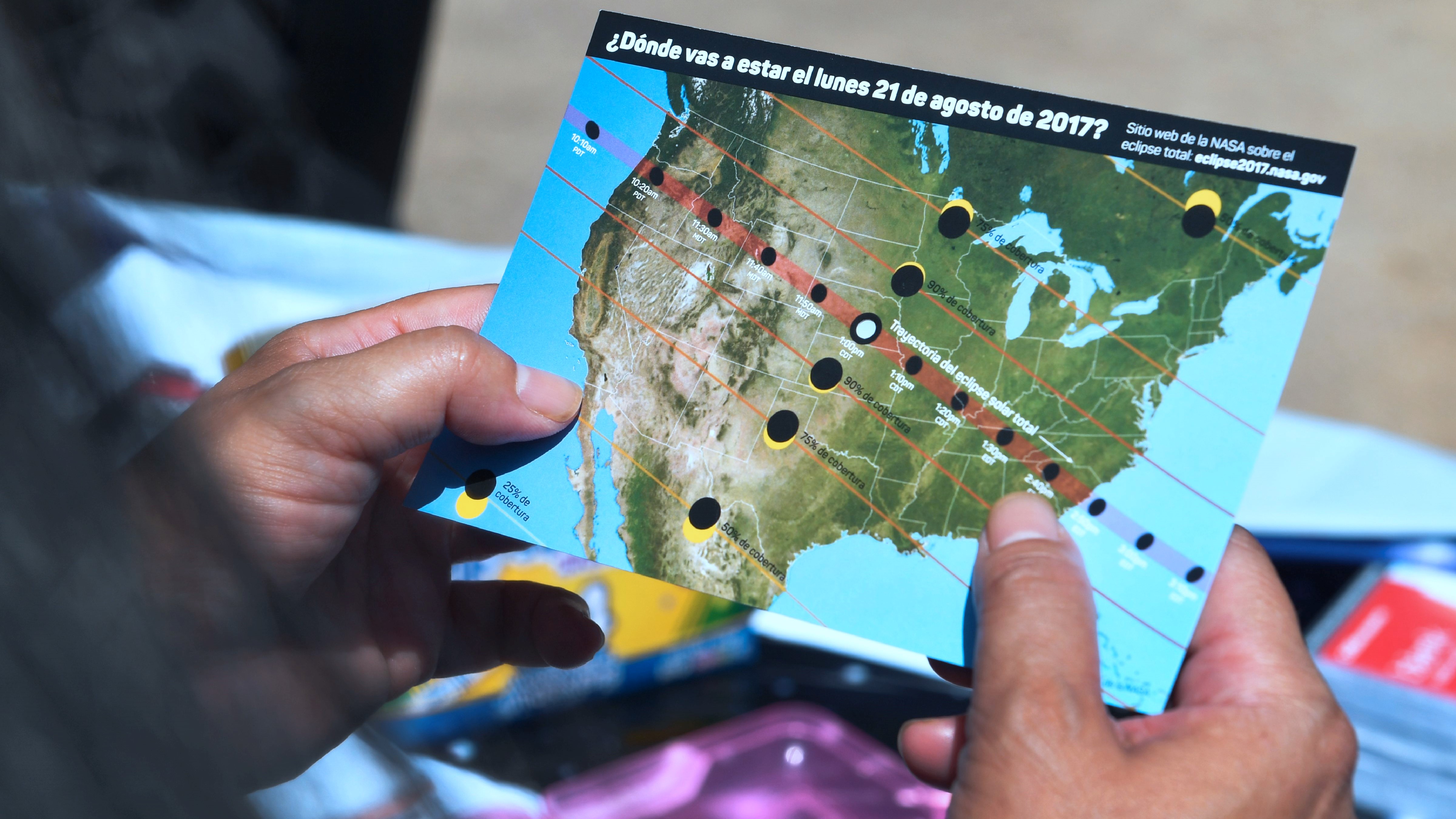
The ultimate prize for any eclipse-chaser is the view of a totally eclipsed sun.
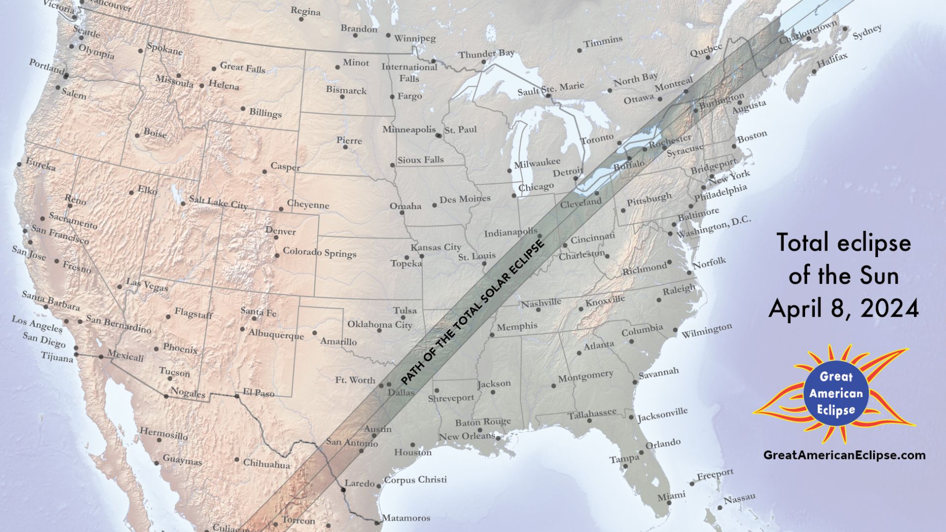
That next happens on April 8, 2024, in North America, when a total solar eclipse will be seen from Mexico, 15 U.S. states and southeastern Canada. Before that, a 'ring of fire' annular solar eclipse will occur on October 14, 2023, across eight U.S. states as well as Central and South America.
Astronomy, geography and meteorology combine to make eclipse-chasing one of the best ways to see the world and experience the best it has to offer. However, making a decision about where to go see a total solar eclipse or an annular solar eclipse is much easier if you can interpret maps of the moon's shadow. By understanding the different parts of that shadow on maps it's possible to have a range of different sights and experiences.
Here's how to understand solar eclipse maps so you can plan an eclipse-chase armed with the knowledge to experience these awe-inspiring celestial events properly and safely.
Related: Road trip! Catch October's annular solar eclipse with 5 iconic routes through the US
Understanding solar eclipses
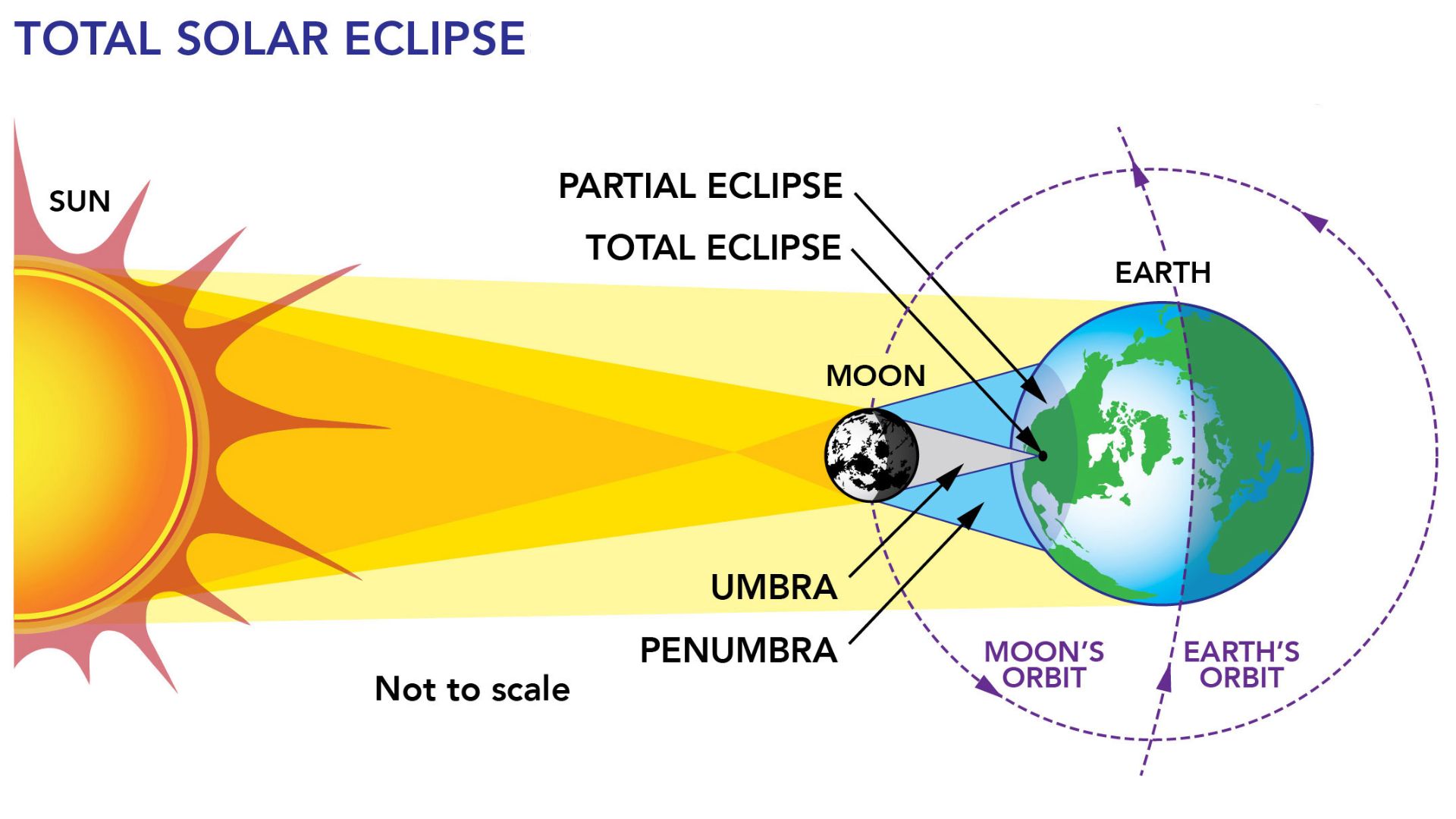
A solar eclipse occurs when a new moon is positioned precisely between Earth and the sun and thus casts a shadow over Earth. There are three main types of solar eclipses depending on how the sun, moon and Earth are aligned at the time of the event:
Partial solar eclipse: The moon doesn't fully block the sun so only a portion of the sun is obscured as seen from Earth. Here the moon appears to take a bite out of the sun. Few eclipse-chasers make plans to travel to see these events, largely because they're common.
Breaking space news, the latest updates on rocket launches, skywatching events and more!
Total solar eclipse: The sun is fully obscured by the moon and the solar corona is visible to the naked eye for a few minutes. This is the most spectacular type of solar eclipse that's worth traveling around the world to see and experience.
Annular solar eclipse: The moon is centered in front of the sun but doesn't cover the entirety of the surface (as seen in a total solar eclipse). Instead a 'ring of fire' shines around the moon. This is the second-best type of solar eclipse and they're mostly viewed by those that live relatively close to the path.
Only total solar eclipses and annular solar eclipses are referred to as central solar eclipses because only during these events do the centers of the sun and moon align with the observer.
Related: How to observe the sun safely (and what to look for)
What do solar eclipse maps show?
Eclipse maps provide the essential information you need to find the best location to experience it. It's not enough just to know the date and location of a solar eclipse because no solar eclipse occurs in just one place. Instead, the moon's shadow traces a path across Earth's surface.
The moon's shadow has two different parts — a large and fuzzy outer penumbral shadow and a smaller darker umbral shadow. From the penumbra, you see a partial solar eclipse only. Within the narrow umbra is the only place you can experience totality. This is called the path of totality. For an annular solar eclipse, the maps show the moon's antumbral shadow, which is the lighter part of a shadow of the moon and where the onlooker must be to see a 'ring of fire' (annulus) around the moon.
Related: 10 best events across the US to celebrate the Oct. 14 annular solar eclipse
How to read a global solar eclipse map
A global solar eclipse map is useful for identifying where on the planet the path of totality or annularity will be — and helps in making a decision on where to go.
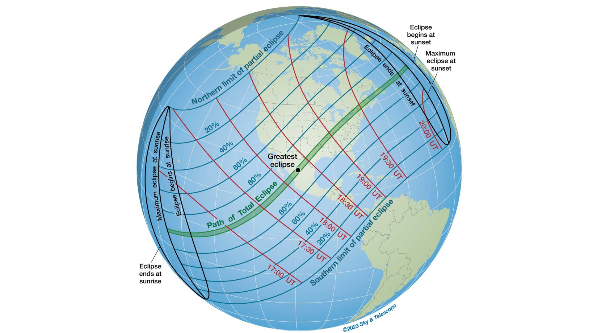
On the global map, above, green shows the central path, red shows the local time of totality and blue shows the max. obscuration of the sun by the moon. It also shows where the moon's shadow first strikes Earth (lower left), is aligned with the center of Earth ('point of greatest eclipse') and leaves Earth (upper right).
The sun appears to rise in the east and set in the west, but during a total solar eclipse, we see the moon's true motion as it crosses the sun from west to east (as Earth rotates from east to west). Solar eclipse maps, therefore, show the path of the moon's shadow as it first touches Earth in the west (as an eclipsed sunrise in the east), travels from east to west, and then leaves Earth in the east (as an eclipsed sunset in the west). Here's what the observer would see at important points on the eclipse map:
- The western end of the path: eclipsed sunrise in the east
- Center of the path: an eclipse at noon at the sun's highest point in the sky
- The eastern end of the path: eclipsed sunset in the west
So as the path moves from west to east the eclipse gets higher in the sky until it peaks at the center of the path. Beyond that, the eclipse gets lower in the sky.
How to read a local solar eclipse map
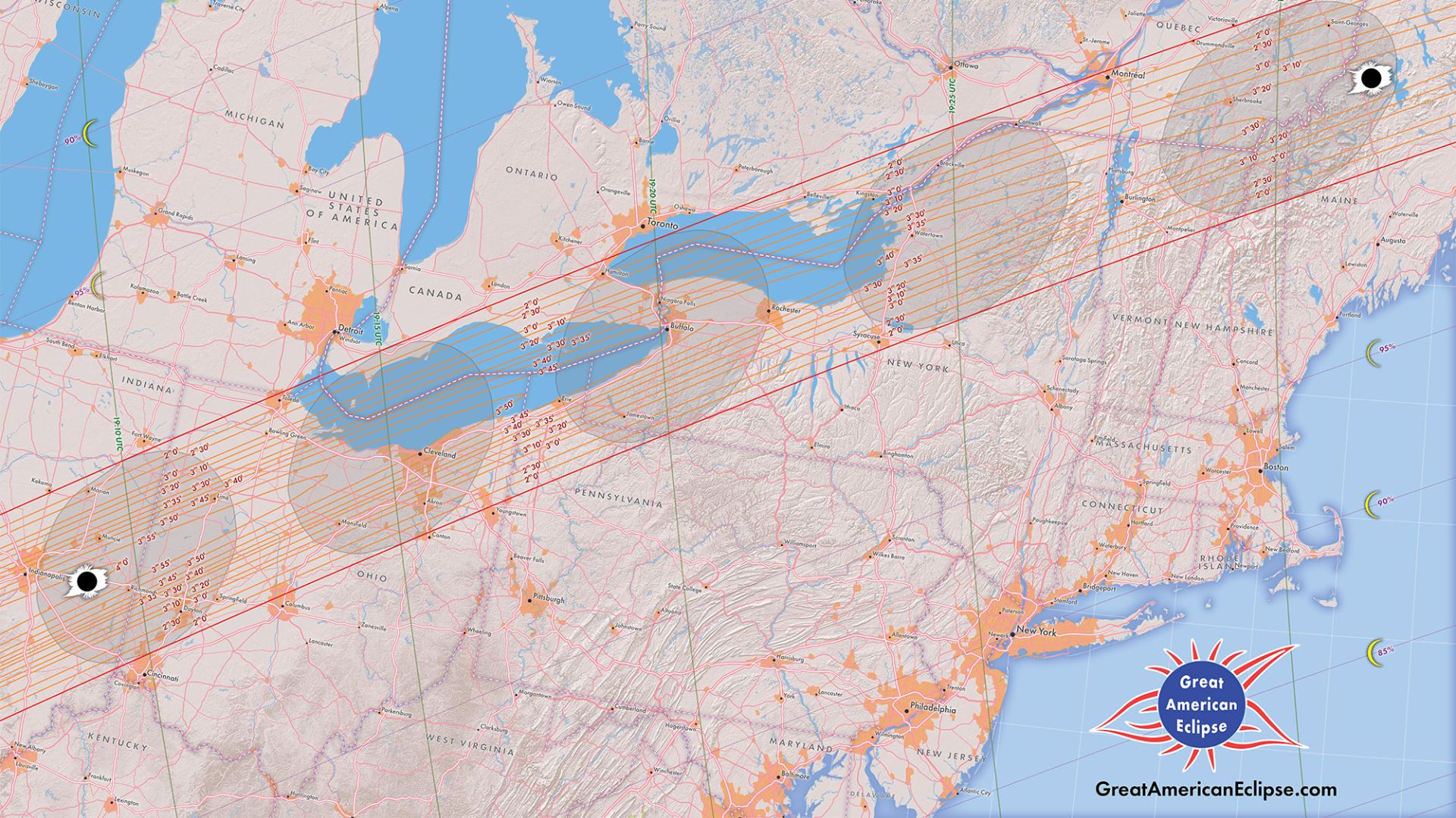
There are two main types of eclipse maps — global and local. A global solar eclipse map is useful for identifying where on the planet the path of totality or annularity will be — and helps in making a decision on where to see an eclipse. A local solar eclipse map zooms in to show the local circumstances of the eclipse for a given region. While global maps are useful as an overview, local maps are essential in finding an exact position. That's because only on a local map can you see in detail the most important aspect of all on any solar eclipse map — the path of totality or annularity where totality or a 'ring of fire' can be seen, respectively.
Related: 10 breathtaking locations to see October 2023's 'ring of fire' annular solar eclipse
Understanding the path of totality
There are two things everyone reading a solar eclipse map needs to know about the path of totality/annularity:
It matters where you are along the path
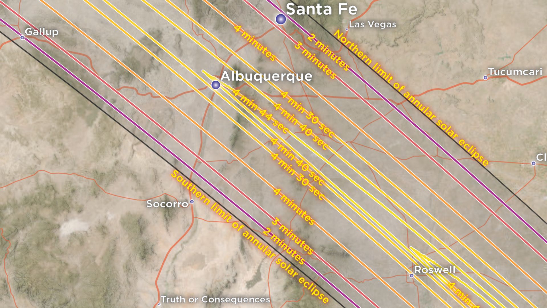
The longest duration of totality/annularity anywhere on the path is in the center as it travels from west to east. It's often shown as a star or otherwise indicated. Technically speaking this is the 'best' place to view the eclipse because it's from here that totality/annularity will last the longest and from where the eclipse will take place highest in the sky.
It matters where you are across the path
Wherever you are along the path of totality/annularity, you should get as close to the centerline as possible if you want to maximize the duration. If you're at the edge of the path you get much less duration. In practice, you don't need to obsess about getting on the centerline, but it's important to stay away from the edge if you want to maximize the duration. Some eclipse chases will purposefully head to the edge of the path to experience different effects, such as extended displays of Baily's Beads, but in doing so they sacrifice the duration of the 'ring of fire' or totality.
The above map shows curves and no specific centerline because they trace the exact shape of the limb of the moon — its mountains and terrain — which can alter the mathematical duration of an eclipse by several seconds.
Related: 'Ring of fire' from US national parks: 7 great places to see the annular solar eclipse 2023
Solar eclipse weather maps
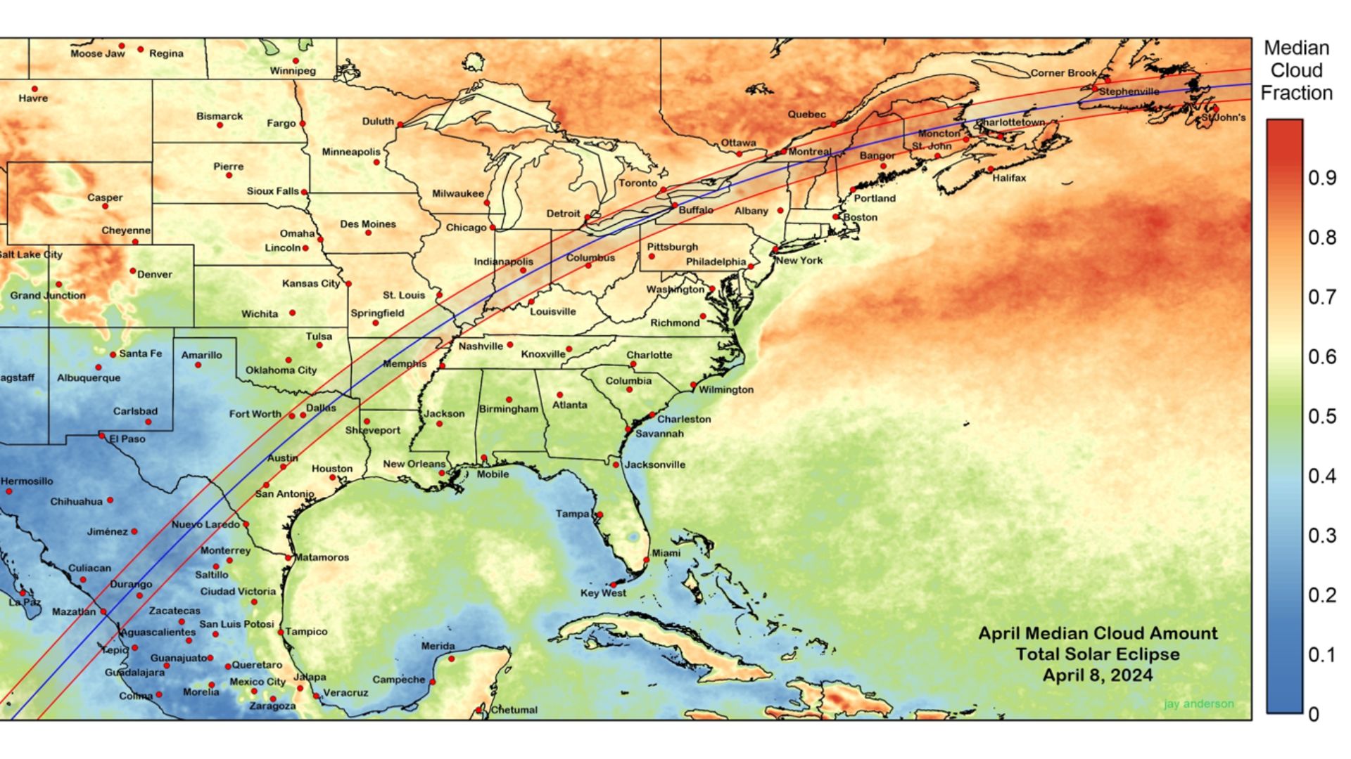
It's not just a case of getting into the path. There's also weather to think about because if it's cloudy it makes no difference where you are — you'll see nothing (though for a total solar eclipse, it will still get dark). The day before the eclipse it's wise to check the weather forecasts and be prepared to drive a few hundred miles to chase clear skies. However, when you're researching where to go it's wise to check the climate.
The map above shows the average percent of cloud cover for the path of totality in April, with blue meaning it's likely to be clear, green meaning 50/50 and orange meaning it's likely to be cloudy. Maps like this could and should help you make a decision about where to go and also set your expectations, but it's only a prediction based on the law of averages. There's a saying among eclipse-chasers: "Climate is what you expect, but weather is what you get." The climate you see reflected on historical maps can be flipped on eclipse day. It pays to check apps and websites like Windy in the days before the eclipse before you make a final decision on where to observe from.
Related: Annular solar eclipse 2023: Everything you need to know
Where to find solar eclipse maps
There are some great resources for solar eclipse maps online all created by a niche of dedicated and experienced eclipse cartographers. Michael Zeiler provides hundreds of classic global, local and themed eclipse maps on GreatAmericanEclipse.com and also curates the history of eclipse maps on Eclipse-Maps.com. Retired astrophysicist Fred Espenak offers maps on Eclipse Wise and was responsible for NASA's eclipse website. French eclipse-chaser Xavier Jubier provides interactive Google Maps of solar eclipse. For eclipse weather maps head straight to meteorologist and avid eclipse-chaser Jay Anderson's website Eclipsophile.
Bibliography
The Atlas of Solar Eclipses — 2020 to 2045 by Zeiler, M and Bakich, M.
Field Guide to the 2023 and 2024 Solar Eclipses by Zeiler, M and Bakich, M.
Road Atlas for the Total Solar Eclipse of 2024 by Espenak, F.
Atlas of Central Solar Eclipses in the USA by Espenak, F.
Historical solar eclipse maps: a short history and chronological albums. Eclipse-maps.com Retrieved August 1 from https://www.eclipse-maps.com/Eclipse-Maps/History/History.html
Interactive Google Maps. http://xjubier.free.fr. Retrieved August 1 from http://xjubier.free.fr/en/site_pages/SolarEclipsesGoogleMaps.html

Jamie is an experienced science and travel journalist, stargazer and eclipse chaser who writes about exploring the night sky, solar and lunar eclipses, the Northern Lights, moon-gazing, astro-travel, astronomy and space exploration. He is the editor of WhenIsTheNextEclipse.com, author of A Stargazing Program For Beginners, co-author of The Eclipse Effect, and a senior contributor at Forbes.
