NASA's Falling UARS Satellite Explained (Infographic)

Get a snapshot view of NASA's Upper Atmosphere Research Satellite (UARS), which will fall to Earth in 2011, in this SPACE.com infographic.
Get a snapshot view of NASA's Upper Atmosphere Research Satellite (UARS), which will fall to Earth in 2011, in this SPACE.com infographic. (Image credit: Karl Tate, SPACE.com Contributor)

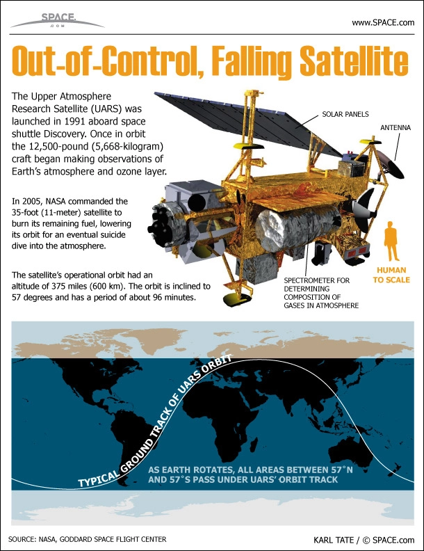
NASA's Upper Atmosphere Research Satellite will fall to Earth in late September after 20 years of orbiting Earth. The satellite was designed to study the Earth's ozone layer for three years after its 1991 launch, but it lasted through 2005, when NASA decommissioned it and set it on course for eventual disposal in Earth's atmosphere. See a profile of the UARS satellite in the infographic above. [Complete Coverage]

Editor's note: This infographic was updated to more accurately depict the possible regions of Earth where the UARS spacecraft could fall.

Join our Space Forums to keep talking space on the latest missions, night sky and more! And if you have a news tip, correction or comment, let us know at: community@space.com.

Karl Tate
Space.com contributor

Karl's association with Space.com goes back to 2000, when he was hired to produce interactive Flash graphics. From 2010 to 2016, Karl worked as an infographics specialist across all editorial properties of Purch (formerly known as TechMediaNetwork).  Before joining Space.com, Karl spent 11 years at the New York headquarters of The Associated Press, creating news graphics for use around the world in newspapers and on the web.  He has a degree in graphic design from Louisiana State University and now works as a freelance graphic designer in New York City.