After Record-Breaking Wildfire Season, California Shows Nine New Scars
California has had a particularly devastating fire season this year, breaking records for the largest fire by burned area and for the deadliest blaze — and that destruction is visible from space.
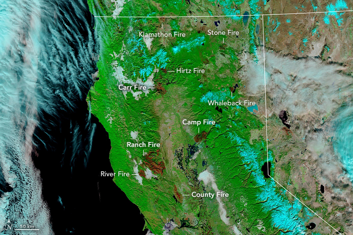
In this staggering image captured by NASA's Terra satellite on Nov. 25, nine different burn scars left behind by this year's fire season are visible. (The image doesn't capture wildfire scars dotting the southern half of the state, like the one left by the Woolsey Fire that burned earlier this month.)
"Every year, we keep hearing fires labeled as 'the biggest', 'worst', and 'deadliest'," Amber Soja, a wildfire scientist at NASA's Langley Research Center, said in a statement. "We keep hearing that this is the 'new normal.' Hopefully it's not true for long, but right now it is."
Those burn scars include the traces of the Camp Fire that destroyed the town of Paradise in mid-November. That fire became the deadliest fire in California's history after it killed at least 85 people. The burn scar it has left behind encompasses 150,000 acres (600 square kilometers).
Earlier in the year, July's Ranch and River fires, which fire specialists dubbed the Mendocino Complex, blazed across even more territory in California — nearly 500,000 acres (2,000 square km). Other burn scars visible in the image include those of the Carr, Whaleback and Country fires. (Fires in California are typically named after geographic features near where they spark in order to help emergency personnel track them.)
NASA satellites play a crucial role in tracking ongoing blazes and helping disaster responders identify areas particularly at risk in their wake — from threats like landslides, which can be devastating where fires have destroyed the vegetation that once anchored soil in place.
Email Meghan Bartels at mbartels@space.com or follow her @meghanbartels. Follow us @Spacedotcom and Facebook. Original article on Space.com.
Breaking space news, the latest updates on rocket launches, skywatching events and more!

Meghan is a senior writer at Space.com and has more than five years' experience as a science journalist based in New York City. She joined Space.com in July 2018, with previous writing published in outlets including Newsweek and Audubon. Meghan earned an MA in science journalism from New York University and a BA in classics from Georgetown University, and in her free time she enjoys reading and visiting museums. Follow her on Twitter at @meghanbartels.

