How Satellites Are Tracking Devastation of California Wildfires from Space

Breaking space news, the latest updates on rocket launches, skywatching events and more!
You are now subscribed
Your newsletter sign-up was successful
Want to add more newsletters?

Delivered daily
Daily Newsletter
Breaking space news, the latest updates on rocket launches, skywatching events and more!

Once a month
Watch This Space
Sign up to our monthly entertainment newsletter to keep up with all our coverage of the latest sci-fi and space movies, tv shows, games and books.

Once a week
Night Sky This Week
Discover this week's must-see night sky events, moon phases, and stunning astrophotos. Sign up for our skywatching newsletter and explore the universe with us!

Twice a month
Strange New Words
Space.com's Sci-Fi Reader's Club. Read a sci-fi short story every month and join a virtual community of fellow science fiction fans!
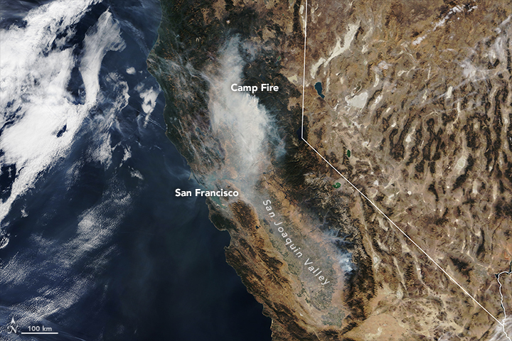
The late-season Camp wildfire is still raging across Northern California, but firefighters are gradually corralling the Woolsey Fire, which has burned swaths of Southern California.
That means that the work of satellites monitoring the fires is shifting. While images of the Camp Fire are still being used to track the blaze itself, scientists are now focusing their satellite analysis on measuring the destruction left behind. [Satellite Photos of the 2018 California Wildfires]
According to CBS News, the Camp Fire has left 56 dead, with more than 100 people missing. California's fire bureau reports that the fire is currently 35 percent contained and has burned 138,000 acres (560 square kilometers).
In Southern California, firefighters are making more headway; the Woolsey blaze is currently 57 percent contained, although it has burned more than 98,000 acres (400 square kilometers).
NASA personnel are also setting to work mapping the damage caused by that blaze. By comparing and contrasting radar images gathered by satellites before and during the fire, a team based at the agency's Jet Propulsion Laboratory has created a map showing where the surface of the Earth has changed. The researchers have shared that map with emergency responders and disaster personnel.
And it's not just scars from the recent fires that satellites can see; even last year's fires are still leaving their mark on the Earth. In these satellite images, the Woolsey burn scar is particularly obvious in the pinkish spot. But to the northwest, a large patch of tannish area marks where the Thomas Fire burned last December.
Email Meghan Bartels at mbartels@space.com or follow her @meghanbartels. Follow us @Spacedotcom and Facebook. Original article on Space.com.
Breaking space news, the latest updates on rocket launches, skywatching events and more!

Meghan is a senior writer at Space.com and has more than five years' experience as a science journalist based in New York City. She joined Space.com in July 2018, with previous writing published in outlets including Newsweek and Audubon. Meghan earned an MA in science journalism from New York University and a BA in classics from Georgetown University, and in her free time she enjoys reading and visiting museums. Follow her on Twitter at @meghanbartels.
