


The volcanic outburst on Hawaii's Big Island intensified early this week, and satellites have been keeping an eye on the dramatic geological activity.
New fissures recently opened around the Kilauea volcano, and the Hawaiian Volcano Observatory (HVO) reported that, on Monday (May 28), lava began erupting from Kilauea's existing "fissure 8" once again. Lava poured into the residential areas of Leilani Estates and Lanipuna Gardens, and the molten material reached a height of 200 feet (61 meters), HVO researchers said. Delicate threads of volcanic glass, known as "Pele's hair," even wafted through the air. You can learn about the science of the Kilauea eruption here from our sister site Live Science.
Kilauea has been erupting since January 1983, but dangerous volcanic activity revved up about a month ago. On April 30, a surge of magma caused the crater floor of the volcano's Pu'u 'Ō'ō vent to collapse and produced excess lava flow. Several earthquakes, particularly the 5.0- and 6.9-magnitude tremors on May 3 and May 4, respectively, preceded the lava inundation. [Hawaii's Kilauea Volcano Eruption as Seen from Space (Slideshow)]
New fissures then opened in the Leilani Estates community. Several satellite instruments are keeping tabs on the activity centered along the Lower East Rift Zone where these new openings appeared, according to officials at the NASA Earth Observatory.
One of the most active of these openings is "fissure 22." NASA officials report that it's gushing so much lava that it formed a new ocean-reaching channel of molten material, which entered the Pacific off the Big Island's southeastern coast near MacKenzie State Park.

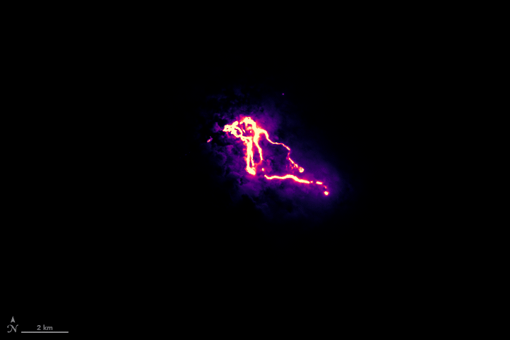
The Operational Land Imager (OLI) instrument on the Landsat 8 satellite watched the lava flow on the night of May 23, NASA officials said, and produced imagery of the event by acquiring shortwave infrared and green-light observations. The NASA Earth Observatory released a short animation of OLI data, which shows the location of roads and coastlines. (Landsat 8 is a collaboration between NASA and the U.S. Geological Survey.)
NASA's Disaster Program has also been tracking volcanic hotspots with the Suomi NPP satellite, a mission run jointly by NASA and the National Oceanic and Atmospheric Administration. The satellite's Visible Infrared Radiometer Suite (VIIRS) instrument is keeping tabs on lava flow, according to a NASA news release published May 25. [In Photos: Fiery Lava from Kilauea Volcano Erupts]

That statement also highlights the work of the Ozone Mapping Profiling Suite instrument on Suomi NPP and the Ozone Monitoring Instrument (OMI) on NASA's Aura satellite, which are monitoring the sulfur dioxide gas released by the volcano. And changes in Kilauea's topography are the focus of the Glacier and Ice Surface Topography Interferometer (GLISTIN), an instrument developed by NASA's Jet Propulsion Laboratory that flies aboard an airplane.
The U.S. Geological Survey provides updates on Kilauea volcano on its website.
Follow Doris Elin Salazar on Twitter@salazar_elin. Follow us @Spacedotcom, Facebook and Google+. Original article on Space.com.
