California Wildfires Continue to Rage (Satellite Photos)

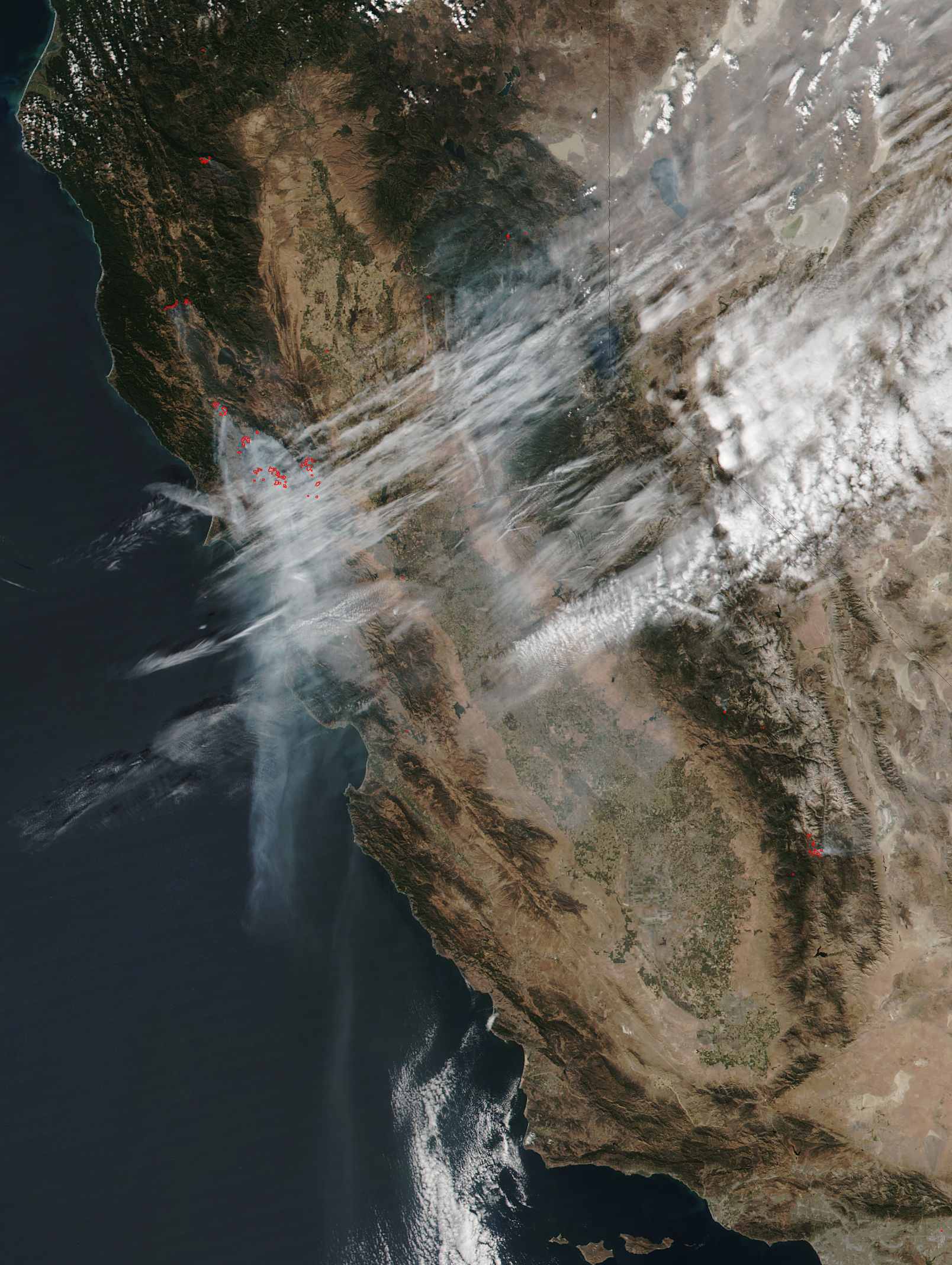
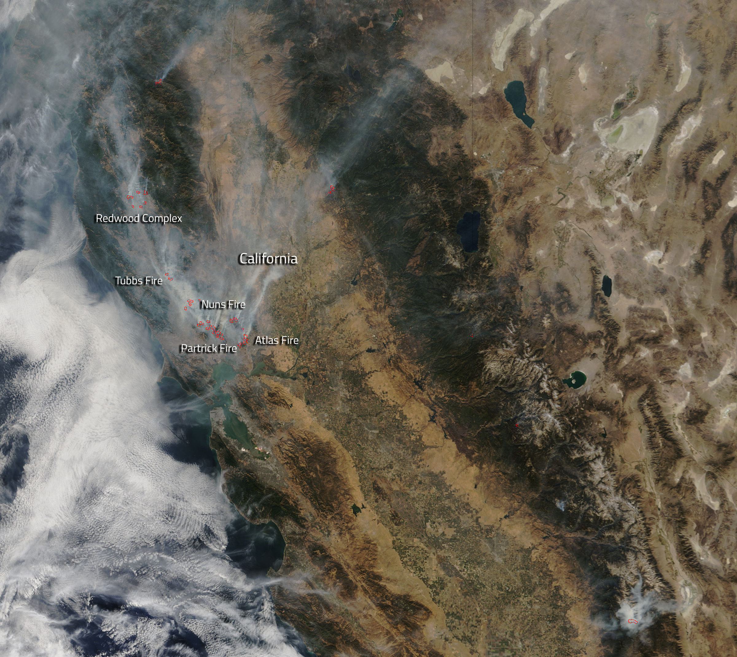
Wildfires continue to burn a path of destruction through California's wine country, as two new satellite photos show.
Both of the images capture the plumes of smoke rising from the nearly two dozen fires ravaging Northern California and identify actively burning areas on the ground.
One of the photos was snapped yesterday (Oct. 11) by the Visible Infrared Imaging Radiometer Suite instrument aboard the Suomi NPP satellite, a joint mission of the U.S. National Oceanic and Atmospheric Administration and NASA. The other was taken Tuesday (Oct. 10) by the Moderate Resolution Imaging Spectroradiometer (MODIS) instrument on NASA's Terra satellite.
The fires started over the weekend and spread quickly throughout Sonoma, Napa, Mendocino and Yuba counties, fueled by strong winds and hot, dry conditions. As of this morning (Oct. 12), the blazes had killed 23 people, destroyed about 3,500 buildings and scorched more than 170,000 acres (69,000 hectares), according to The Washington Post.
Those numbers are likely to get worse, however.
"Officials expect the death toll to rise — perhaps significantly — when officers begin going into the 'hot zones' that were immolated in the firestorm," The Washington Post wrote.
Officials are still working to determine what caused the fires. To get the latest information about each blaze, go to the California Department of Forestry and Fire Protection homepage: http://calfire.ca.gov
Breaking space news, the latest updates on rocket launches, skywatching events and more!
The Suomi NPP (National Polar-orbiting Partnership) satellite launched in October 2011. The spacecraft performs a wide variety of Earth-observation work with its five scientific instruments. For example, its measurements are helping researchers better understand climate change, predict weather and monitor air pollution and natural disasters, NASA officials have said.
The Terra satellite launched in December 1999 to investigate Earth's systems in detail. The spacecraft uses five different scientific instruments to study the planet's atmosphere, climate and weather; water, energy and carbon cycles; ecosystems; and surface and interior.
The MODIS instrument also flies aboard Terra's sister satellite, Aqua, which launched in May 2002 to study the planet's water cycle, among other things. Aqua has been monitoring the California wildfires as well.
Follow Mike Wall on Twitter @michaeldwall and Google+. Follow us @Spacedotcom, Facebook or Google+. Originally published on Space.com.

Michael Wall is a Senior Space Writer with Space.com and joined the team in 2010. He primarily covers exoplanets, spaceflight and military space, but has been known to dabble in the space art beat. His book about the search for alien life, "Out There," was published on Nov. 13, 2018. Before becoming a science writer, Michael worked as a herpetologist and wildlife biologist. He has a Ph.D. in evolutionary biology from the University of Sydney, Australia, a bachelor's degree from the University of Arizona, and a graduate certificate in science writing from the University of California, Santa Cruz. To find out what his latest project is, you can follow Michael on Twitter.


