Hurricane Dorian: How NASA and NOAA Are Tracking the Storm from Space
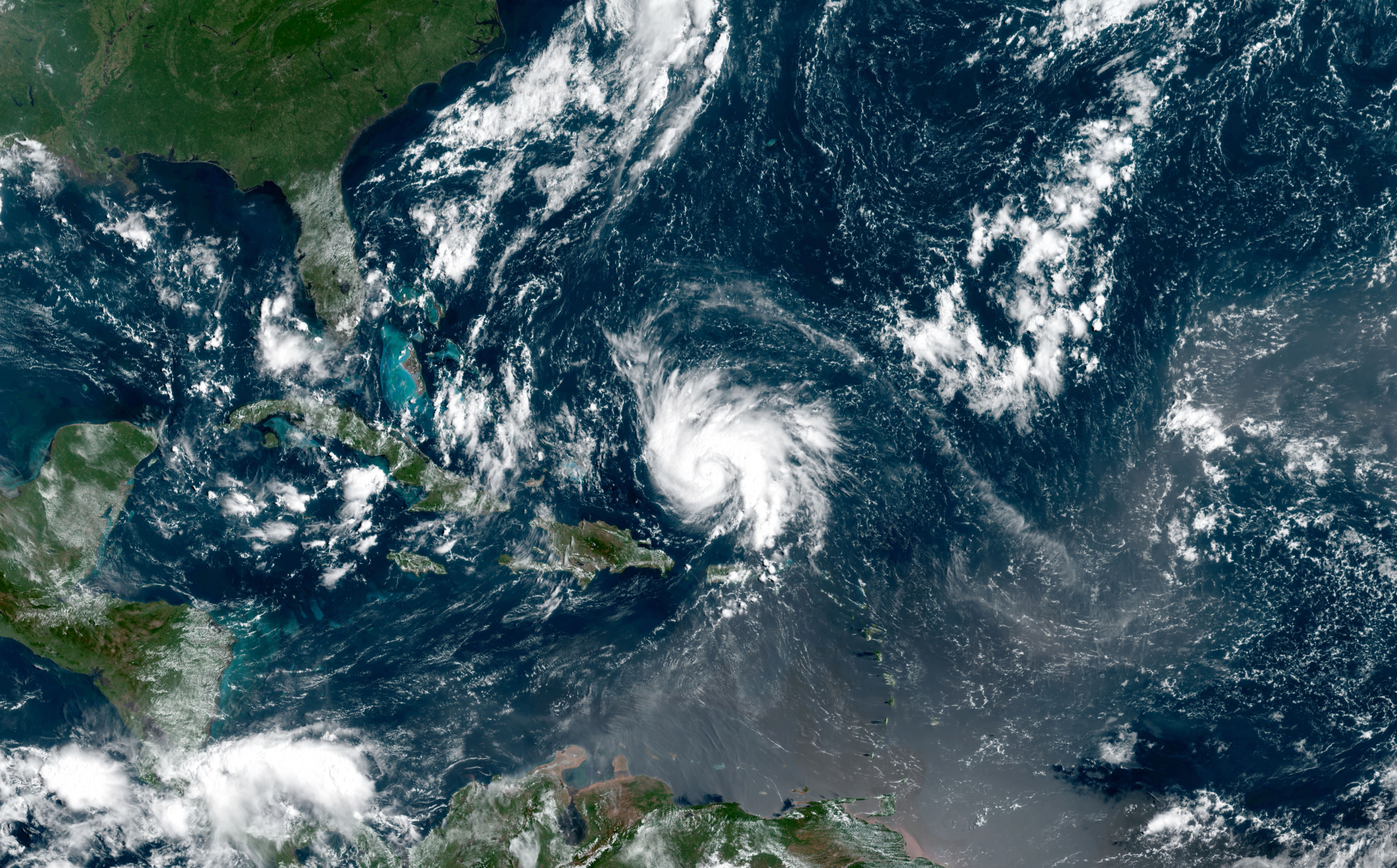
No matter how you look at it, Hurricane Dorian is a scary sight.
But the more eyes on the storm, the better chance meteorologists and emergency responders have to keep people safe. And so NASA and the National Oceanic and Atmospheric Administration (NOAA) have a host of satellites studying the hurricane.
All of the data those satellites gather go into statements issued by NOAA's National Hurricane Center (NHC), which is currently forecasting that Dorian will head west across the northern Bahamas as a major hurricane over the weekend, then hit southern Florida as a hurricane, albeit a slightly weaker one, on Tuesday (Sept. 3).
Related: NASA Sees Hurricane Dorian from Space Station (Video)
NASA has a particularly strong interest in Dorian, since the storm is currently predicted to wallop the agency's main spaceport, Kennedy Space Center. The facility's personnel have been preparing for the storm since Wednesday (Aug. 28).
High on the list of concerns was the Mobile Launcher, a 400-foot-tall (122 meters) that will support NASA's new SLS rocket designed for deep-space missions. Such a tall structure is an obvious hazard in hurricane-force winds, and personnel arranged for it to be moved into Kennedy's 52-story-tall Vehicle Assembly Building to wait out the storm.
The Kennedy Space Center Visitor Complex also decided to close on Sunday (Sept. 1) for safety.
Breaking space news, the latest updates on rocket launches, skywatching events and more!
The International Space Station has passed over the storm and added to the observations meteorologists are relying on from satellites. Those satellites are particularly tuned to calculating rainfall and studying the structure of the storm clouds that make up the hurricane.
Orbiting at approximately the same altitude as the space station is a tiny weather satellite called Temporal Experiment for Storms and Tropical Systems Demonstration (TEMPEST-D). About the size of a cereal box, TEMPEST-D can spot the areas of highest moisture in the storm and is part of a test program to miniaturize weather satellites to blanket the globe in real-time storm tracking technology.
NASA's Aqua satellite carries an Atmospheric Infrared Sounder instrument that can identify the very tall thunderstorm clouds associated with the heaviest rainfall, which appear cooler to its sensors.
📷 CloudSat shows a 3D animation of Dorian, still a tropical storm at the time, near Puerto Rico. CloudSat "slices" through clouds, enabling us to see their height, their different layers and the areas where the heavier bands of rain are found within the storm system. pic.twitter.com/ME7LKIl6GBAugust 30, 2019
Another instrument, onboard NASA's CloudSat satellite, produces cross-section imagery of knots of clouds. Scientists can learn about the height and layers of clouds and the size of the precipitation droplets inside of them, which helps them identify where in the storm carries the most threatening rainfall.
One NASA-run model pulls these types of data together, and a preliminary analysis of it suggested that certain areas affected by the storm could receive nearly 5 inches (120 millimeters) of rain within 24 hours, according to a statement.
- Hurricane Florence Is a 'No-Kidding Nightmare' in These New Astronaut Photos
- Huge Hurricane Florence Looms Large in New Views from Space (Video)
- Hurricane Florence Looks Like a Giant Cotton Ball in This Astronaut Photo from Space
Email Meghan Bartels at mbartels@space.com or follow her @meghanbartels. Follow us on Twitter @Spacedotcom and on Facebook.

Meghan is a senior writer at Space.com and has more than five years' experience as a science journalist based in New York City. She joined Space.com in July 2018, with previous writing published in outlets including Newsweek and Audubon. Meghan earned an MA in science journalism from New York University and a BA in classics from Georgetown University, and in her free time she enjoys reading and visiting museums. Follow her on Twitter at @meghanbartels.


