How satellites have revolutionized the study of volcanoes
Ten years ago, we would have known much less about the Tonga volcanic eruption.
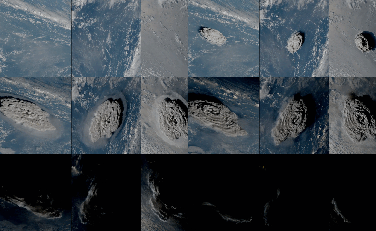
Developments in satellite technology over the past decade have allowed the world to witness the devastating Hunga Tonga-Hunga Ha'apai eruption and its aftermath in real time and in unprecedented detail. The findings might shed light on the anatomy of rare explosive volcanic eruptions and their effects on the planet. But satellites are also helping volcanologists keep an eye on Earth's more common (though less eye-catching) outbursts.
The last time a volcano erupted as violently as Hunga Tonga-Hunga Ha'apai was 30 years ago. At that time, satellites monitoring Earth were few and far between. Those watching the planet's surface were mostly run by the military. The European Space Agency (ESA), now an Earth-observing super-power, was only about to launch its first Earth-observing mission, the Remote-Sensing Satellite-1 (ERS-1). Cubesats that have since become a cornerstone of commercial Earth-observing constellations, such those of the U.S.-based company Planet, were yet to be invented.
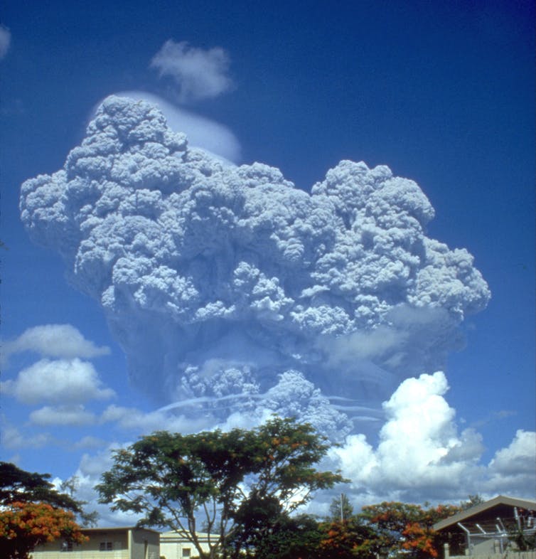
Still, the eruption of Mount Pinatubo in 1991 was the most explosive volcanic event detected by satellites at that time, having been photographed by a Japanese weather satellite sitting 22,000 miles (36,000 kilometers) above Earth and a spacecraft of the U.S. National Oceanic and Atmospheric Organization that circled the planet in polar orbit.
Related: Ash from Tonga volcano eruption reaches record altitude but climate cooling unlikely
In real time
But the detectors and cameras on satellites in the 1990s were nowhere near as capable as what flies around Earth today. And so the amount of data was nowhere near as detailed to what the Hunga Tonga-Hunga Ha'apai eruption has produced.
"In a sense, we are really lucky to have all these satellites in orbit now," Simon Proud, a research fellow in satellite data and meteorology at the University of Oxford, told Space.com. "This is something even five years ago we wouldn't have had."
Proud was one of the hundreds of researchers all over the world captivated by the data pouring in from the orbiting sensor networks after the Hunga Tonga-Hunga Ha'apai eruption rippled through the southern Pacific Ocean on Saturday (Jan. 15). First there was the nuclear-like blast that has since been described as 500 times as powerful as the Hiroshima bomb. Then came the shockwave that circumnavigated the globe, confusing weather forecasting models all over, and the cloud of ash thrown so high up into the atmosphere that it has not been seen before.
Breaking space news, the latest updates on rocket launches, skywatching events and more!
That volcanic cloud was of particular interest to Proud. He has since found that it reached record altitudes of more than 30 miles (50 km).
"Our latest data says that the main volcanic 'umbrella' reached 35 km [22 miles] altitude, but some points may have reached 55 km [34 miles] altitude!" Proud said on Twitter, adding that the "shocking altitudes ... show just how violent this eruption was."
However, he cautions that this record is partly due to the availability of measuring technology.
"We think that Pinatubo probably got up that high too, but we missed it with the technology we had," he said. "What is really interesting from a science perspective about this event, is both just how high it went and over the coming days and weeks how it will interact with the atmosphere up there."
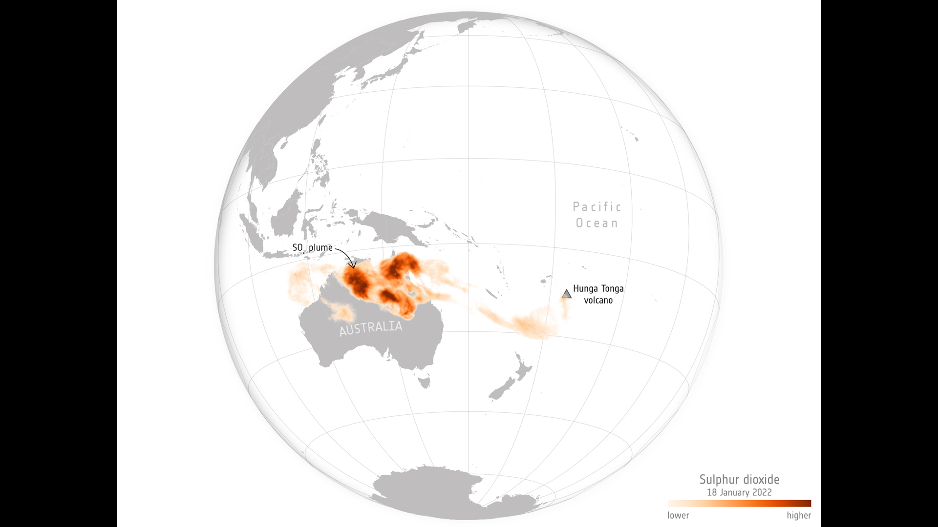
Scientists already know that the Hunga Tonga-Hunga Ha'apai volcanic cloud contained a relatively low amount of sulfur dioxide, compared to, for example, the Mount Pinatubo eruption. Sulfur dioxide is of great interest as it can reflect sunlight when dispersed in the atmosphere, thus changing how much heat the planet traps. Because of its sulfur dioxide content, the Mount Pinatubo eruption cooled down the planet by 1 degree Fahrenheit (0.6 degrees Celsius) in a way that was measurable for two years. Current estimates, however, suggest that despite its cataclysmic proportions, the Hunga Tonga-Hunga Ha'apai volcanic cloud contained only 2% of the amount of sulfur dioxide of Mount Pinatubo.
Uncorked champagne bottle
The difference, however, is not due to the size or force of the blast, volcanologist Jeffrey Karson, of the University of Syracuse in New York, told Space.com.
"That has to do with the source of the molten rock at depth," Karson said. "Some volcanic material has a lot of sulphur, some has very low sulphur. It depends on the source."
The force of the Hunga Tonga-Hunga Ha'apai blast, the greatest the planet witnessed since the 1991 eruption of Mount Pinatubo, was a result of a combination of factors, according to Karson.
"There is nothing geologically unusual about this volcano," Karson said. "It's one of thousands of volcanoes around the Pacific Rim, the so-called 'Ring of Fire,' where the Pacific Ocean is being stuffed underneath the surrounding lithospheric plates. It's a process that drives most volcanism on our planet."
The water mixing with the magma triggers chemical reactions that are not present in volcanoes erupting on dry land. The water mixes with the molten rock, creating bubbles of gas The high temperature in the volcanic vent pressurizes the mixture like a bottle of champagne. At some point, the pressure is high enough to displace the "cork" on that volcanic champagne bottle. How long the volcanic "cork" stays in place and how ferociously it flies away depends on the column of water above, Karson said.
"If there's a lot of pressure on the system, in other words, the water is relatively deep, then the lids are kept on that system and the gases leak out rather slowly," said Karson. "If it's close to the surface, there's no water pressure to hold the lid on the system and those gases come out catastrophically."
The gas can expand one thousand times in volume as it changes from the liquid form, said Karson; a process that happens instantly, blowing apart rock with explosive force.
Where will the next one explode?
Satellites, Karson admits, played an indispensable role in monitoring the Hunga Tonga-Hunga Ha'apai eruption. Volcanologists place sensors on volcanoes they believe might become active. But there is still very little known about the processes inside Earth, and estimates are very crude at best.
"We don't know when the next eruption is going to take place on a particular volcano, so we put instruments on the ones that we think are most active," Karson said. "But this particular volcano was not instrumented very much at all."
Despite the technological boom of the past decade, satellites still don't provide such a detailed picture as ground-based sensors. Still, much can be learned from their data and images about the scale of the impact, the spread of the volcanic cloud and changes to the terrain around the volcano.
"There is a lot that can be done," said Karson. "For example, you might wonder how much the ground level changed, and that can be determined from satellites as well these days. But the gases, for example, get dispersed in the atmosphere and can end up being diluted and difficult to measure from those great heights.
Slow-burning destruction
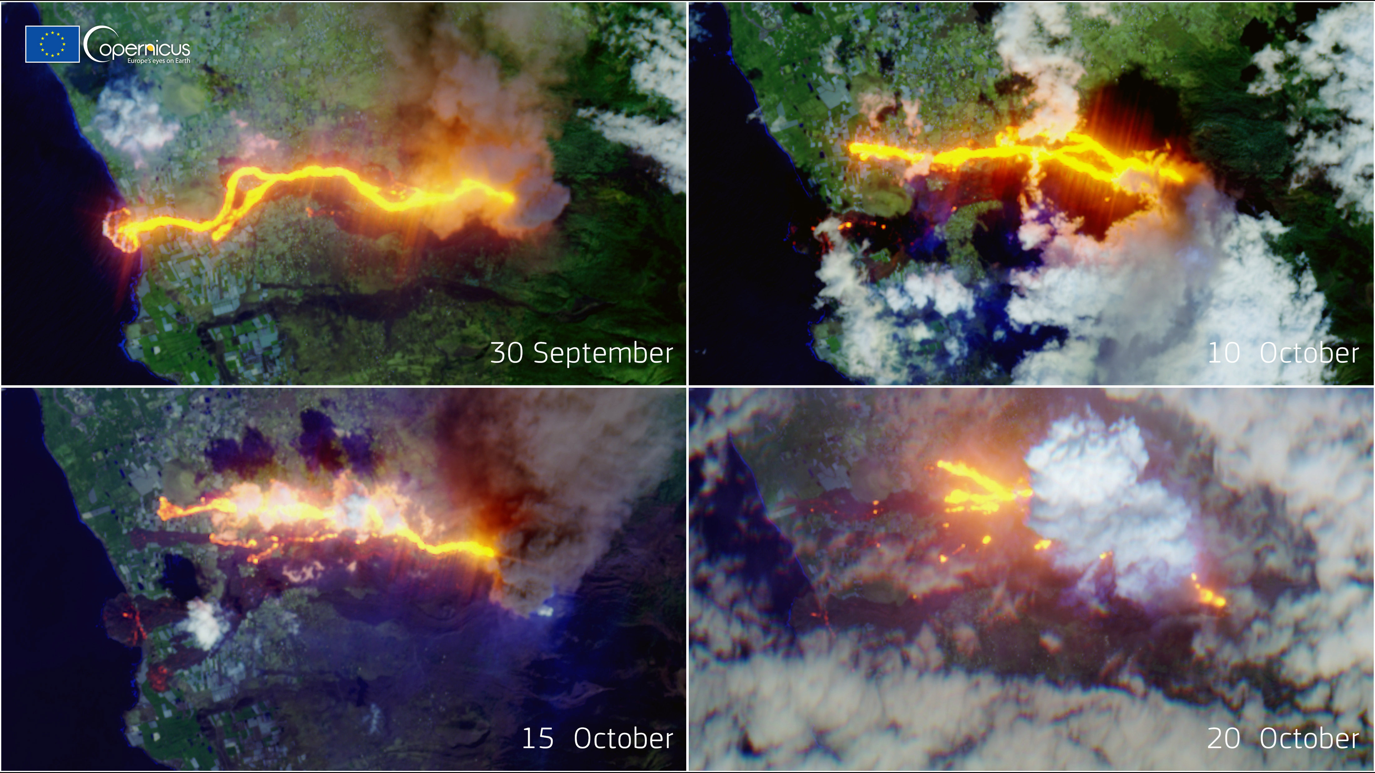
Karson's primary research interests are the more modest, slow-burning volcanoes that throw up lava over weeks and months, frequently causing severe but more predictable damage that people can prepare for. Even those volcanoes benefit from satellite monitoring. For example, the damage caused by the Cumbre Vieja volcano on the Canarian island of La Palma in the Atlantic Ocean last year was assessed in detail almost on a daily basis by satellites of the European constellation Copernicus. Analysts could count individual buildings that vanished in the lava river and calculate the exact area of land buried by the molten rock.
"Nowadays it's pretty common even in incredibly remote areas to capture [volcanic eruptions] with satellites," Karson said. "There's more and more satellites all the time now. They have different systems on them and so we are much better positioned to make different kinds of observations."
Keeping an eye on the cloud
The scale of the impact of a volcanic eruption may not necessarily be directly proportional to its ferocity, Karson added.
For example, the slow-burning 2010 eruption of the Eyjafjallajökull volcano in Iceland produced huge amounts of ash that was extremely dangerous to aircraft. Almost 100,000 flights had to be grounded on busy cross-Atlantic routes as a result of the eruption.
Hunga Tonga-Hunga Ha'apai, on the other hand, threw up its debris in a rather remote area of the Pacific Ocean that not that many flights cross. Scientists, however, still carefully monitor the spread of the cloud, which has since crossed Australia and has started spreading over the Indian Ocean.
"The ash cloud will eventually spread very thinly globally," said Proud. "Over the next few weeks it will probably remain in the Southern Hemisphere, following the winds across the southern Indian Ocean and towards the southern part of Africa."
For now, most of the cloud is way above the cruising altitude of aircraft, he added. Even though the explosion is over, satellites will keep their eyes peeled on Hunga Tonga as well as the volcanic cloud for weeks to come. Proud said some unexpected insights might come out of the research. For example, due to its altitude, the volcanic ash might interact with the ozone layer, something that has never been studied before.
Follow Tereza Pultarova on Twitter @TerezaPultarova. Follow us on Twitter @Spacedotcom and on Facebook.
Tereza is a London-based science and technology journalist, aspiring fiction writer and amateur gymnast. She worked as a reporter at the Engineering and Technology magazine, freelanced for a range of publications including Live Science, Space.com, Professional Engineering, Via Satellite and Space News and served as a maternity cover science editor at the European Space Agency.
