


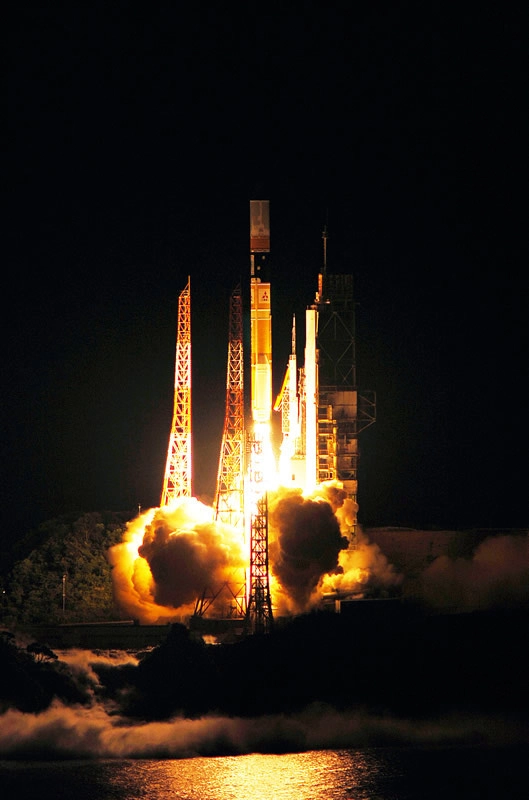
An H-2A rocket flew to space Saturday with aJapanese satellite to meet a pressing need for improved navigation servicesamid the country's numerous mountains and high-rise buildings.
The rocket's payload is the first of threeplanned satellites to fill coverage gaps from U.S. Global PositioningSystem satellitescausedby signal blockage from mountains and skyscrapers. [Photo of the satellite's launch.]
Developed by the Japan Aerospace ExplorationAgency and four government ministries, the Quasi-Zenith Satellite System isaimed at overcoming ground interference by launching more navigation satellitesstrategically positioned high in the sky above Asia.
The line-of-sight navigation signals from GPSsatellites can be interrupted in rural hamlets and skyscraper-filled citieslike Tokyo, where users occasionally lack sufficient data to determine theirposition, elevation and time.
JAXA says a constellation of three QZSS spacecraft would makethree-dimensional navigation coverage available 99.8 percent of the time, animprovement over the estimated 90 percent availability with GPS satellitestoday.
Four GPS satellites must appear in the sky atone time to triangulate a user's 3D position and time, but buildings andmountains can block signals from spacecraft close to the horizon.
The first QZSS navigation craftlaunched Saturdayon an H-2A rocket. Its nickname is Michibiki, which means "guiding"or "showing the way" in Japanese.
Michibiki is demonstrating the system'snavigation instruments and proving the satellite works before Japan commits tolaunching the other two spacecraft.
The 17-story launcher lifted off at 1117 GMT(7:17 a.m. EDT) from Launch Pad No. 1 at the Yoshinobu launch complex, ashoreline facility at the Tanegashima Space Center off the coast of Kyushu, thesouthernmost of Japan's main islands.
With twin 49-foot-long solid rocket boostersgiving the rocket an extra burst of energy, the H-2A illuminated a mostly clearevening sky over Tanegashima, where it was 8:17 p.m. Saturday local time.
The boosters burned up their solid propellant97 seconds after liftoff and jettisoned back into the Pacific Ocean 10 secondslater, leaving the rocket's single hydrogen-fueled main engine to fire forabout five more minutes.
The rocket's nose cone split open and fellfrom the vehicle as planned at T+plus 4 minutes and 10 seconds. The shroud wasno longer needed as the rocket reached an altitude of 93 miles.
Flying southeast over the Pacific Ocean, thelauncher's first stage finished its work at T+6 minutes and 36 seconds, givingway to a smaller second stage engine.
The upper stage fired twice, first to placeitself in a low-altitude parking orbit, then to inject Michibiki on a higherpath that will eventually park the spacecraft more than 20,000 miles aboveEarth.
The launch vehicledeployed Michibiki at 1145 GMT (7:45 a.m. EDT) as it flew south of Hawaii. Avideo camera mounted on the rocket's second stage captured live footage of thenearly 9,000-pound spacecraft sailing away.
JAXA says Michibiki will reach its finalorbit in about two weeks. It will be three months before the satellite finishescommissioning tests and can begin its navigation demos.
Michibiki will circle the Earth at a45-degree angle to the equator. Its orbital high point will be more than 24,000miles over the northern hemisphere and its lowest altitude will be 20,500miles, according to JAXA.
Projected against Earth's surface,Michibiki's ground track will chart an asymmetric figure-eight patternstretching from Japan to Australia as it alternates north and south of theequator.
Michibiki will be near-zenith, or almoststraight up, in the Japanese sky for about eight hours each day. If launched,the two follow-on satellites would permit continuous coverage of Japan.
The GPS constellation, operated by the U.S.Air Force, flies 11,000 miles above Earth. Although there are 30 operationalGPS spacecraft, only a small fraction of the fleet is visible from a singlepoint on Earth at one time.
To illustrate GPS shortfalls in Japan, theQZSS project manager points out that full navigation service is not alwaysguaranteed in the heart of the world's largest metropolis.
Three-dimensional positioning information isavailable less than half the time in some streets and alleys in Tokyo's Ginzaward, according to Koji Terada, QZSS project manager.
Terada says the services will be available inGinza more than 90 percent of the time with the launch of a single QZSSspacecraft.
Built by Mitsubishi Electric Corp., Michibikiwill broadcast four L-band navigation signals compatible with GPStransmissions, but JAXA officials say users will need special receivers to takeadvantage of its augmented navigation capabilities.
If subsequent QZSS satellites are cleared forlaunch, engineers could develop standardized receivers for car and cell phonenavigation systems.
- 20Great Rocket Launches
- JapanAims for Venus, Part2
- Europe,Japan Weigh Cargo Return from Space Station
Copyright 2010 SpaceflightNow.com,allrights reserved.