The Hunga Tonga volcanic eruption that sent shockwaves through Earth in January 2022 generated the highest volcanic cloud since at least the Krakatoa eruption of 1883, a new study reports. And the amount of water the volcano injected into Earth's atmosphere may have warmed the planet's climate.
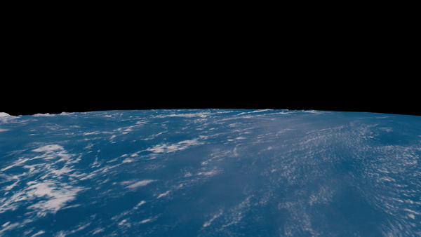
The volcanic eruption that tore apart the Polynesian island of Hunga Tonga-Hunga Ha'apai on Jan.15 was a disaster locally, but it has also proved to be a scientific gift that keeps on giving. The previously unassuming underwater volcano in a remote region of the southern Pacific Ocean exploded with unprecedented force in full view of three weather satellites. These satellites allowed scientists all over the world to observe the mind-boggling explosion in real time and study its aftermath in unprecedented detail.
Among the researchers captivated by the mushroom of water vapor and mineral ash that burst toward the sky on that fateful Sunday evening was Simon Proud, an Earth observation scientist at the STFC Rutherford Appleton Laboratory and the University of Oxford in the U.K.
Related: Huge Tonga volcanic eruption spawned record-breaking winds at the edge of space
Proud, the lead author of a new study analyzing the plume, quickly realized that the Hunga Tonga eruption was quite out of the ordinary. For example, temperature measurements returned by Earth-observation satellites suggested that the volcanic cloud must have reached an unprecedented altitude.
"When [the cloud] was developing, we were looking at the temperatures based on the satellite data," Proud told Space.com. "It went through the troposphere, where the temperature decreases with height, and then it kept getting cooler even though the atmosphere around it should have been getting warmer."
Scientists usually estimate the altitude of atmospheric phenomena by measuring their temperature using satellite-borne infrared sensors and comparing these measurements with the temperature of the surrounding atmosphere. In the troposphere, the layer of Earth's atmosphere closest to the planet's surface, temperature falls with altitude following known rules of physics. But these rules no longer apply in the stratosphere, the atmospheric layer that extends from 9 miles to 30 miles (15 to 50 kilometers) of altitude, where the ozone layer absorbs the ultraviolet radiation streaming from the sun, forcing temperatures upward. Since the temperature of the Hunga Tonga cloud kept falling, Proud realized that estimating the altitude accurately would require a more ingenious approach.
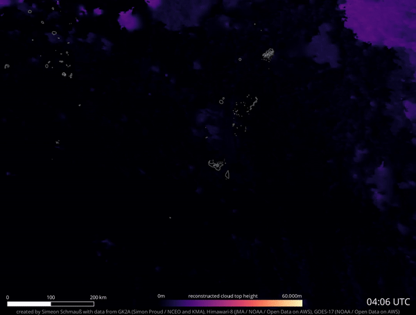
Because three different weather satellites observed the eruption from three different positions in geostationary orbit, an orbit at roughly 22,000 miles (36,000 km) high where objects appear suspended above a fixed spot on Earth, Proud managed to calculate the altitude of the top of the cloud using a method known as parallax.
Parallax allows researchers to calculate the distance to an object using the apparent distances as observed from at least two different locations. It is commonly used to calculate distances of stars, and Proud previously used it to calculate the altitude of the Chelyabinsk meteor that exploded over Russia in 2013.
"We were really lucky that we had the area covered with three satellites," Proud said. "[The calculation] produced really nice results; it worked very well for such a high volcano. We've never seen everything this high before."
The calculation revealed that the Hunga Tonga cloud burst not only through the troposphere but also ascended through the entire stratosphere, only plateauing at the altitude of 35 miles (57 km), way into the freezing and dry layer known as the mesosphere. This makes the Hunga Tonga volcanic cloud the highest ever observed and most likely the highest in over a century.
"The last [volcanic eruption] that could have reached this height was Krakatoa in 1883," said Proud. "There have been some more recent [eruptions] such as [the 1991 eruption of] Mount Pinatubo, and we think we underestimated the height of those, but not to the same extent."
Ash from the Mount Pinatubo eruption was detected at altitudes of nearly 25 miles (40 km). Proud believes that if better satellites were in orbit at that time, traces of the cloud would have been seen even 6 miles (10 km) higher, but still short of Hunga Tonga's 35 miles.
The Pinatubo ash in the stratosphere cooled the Earth's climate by 1 degree Fahrenheit (0.6 degrees Celsius) due to the presence of sulfur dioxide in the volcanic material. Sulfur dioxide reflects radiation and is frequently studied as part of potential geoengineering interventions designed to slow down climate change.
When Hunga Tonga exploded, scientists thought the eruption could trigger a similar effect (which was, in the case of Pinatubo, observable for two years). Subsequent measurements, however, revealed that the Hunga Tonga cloud contained only about 2% of the sulfur dioxide generated by Pinatubo, not enough to affect the climate in any measurable way. Proud, however, says that the amount of water sprayed by the explosion into the stratosphere may actually warm the climate.
"This volcano put a lot of water into the stratosphere and also some into the mesosphere," Proud said. "Water in the stratosphere generally warms Earth's surface. So this could actually contribute to some surface level warming of Earth over the next few years. We have very good temperature data for the lower atmosphere, so that's something we should be able to figure out quite quickly."
A study published earlier this year found that Hunga Tonga injected an equivalent of 58,000 Olympic-size swimming pools into Earth's atmosphere, potentially increasing the amount of water vapor in the stratosphere by 5%.
The effects on the mesosphere, Proud said, may be more subtle and come with some rather intriguing side effects.
"Mesosphere is usually the driest layer of the atmosphere, and putting extra water up there could mean that we get more polar mesospheric clouds," Proud said. "These clouds are becoming more common anyway, probably due to climate change, so I want to look at satellite data and see whether I can see an increase after this eruption."
Polar mesospheric clouds, also known as noctilucent clouds for their ability to glow at night, form during summer months above the polar regions at altitudes of 47 miles to 53 miles (76 to 85 km). These clouds frequently popped up following space shuttle launches, which emitted huge amounts of water vapor in their rocket exhaust.
The mesosphere, Proud said, is rather unexplored as it is too low for satellites to fly through but too high for balloons to reach. The Hunga Tonga eruption may therefore present a unique incentive for scientists to look at the chemical processes unfolding in this region.
Researchers are by no means done with the Hunga Tonga eruption. Many questions remain unanswered, including its exact effect on Earth's climate and the reason why it exploded with such force after centuries of lukewarm activity.
The new study was published online in the journal Science today (Nov. 3).
Follow Tereza Pultarova on Twitter @TerezaPultarova. Follow us on Twitter @Spacedotcom and on Facebook.