A new video shows the dramatic moment a new NASA spacecraft spread its metaphorical wings unfolding its most vital instrumentation while in orbit around Earth.
The SWOT satellite (its name is short for Surface Water and Ocean Topography) launched into space from Vandenberg Space Force Base in central California aboard a SpaceX Falcon 9 on Dec. 16.
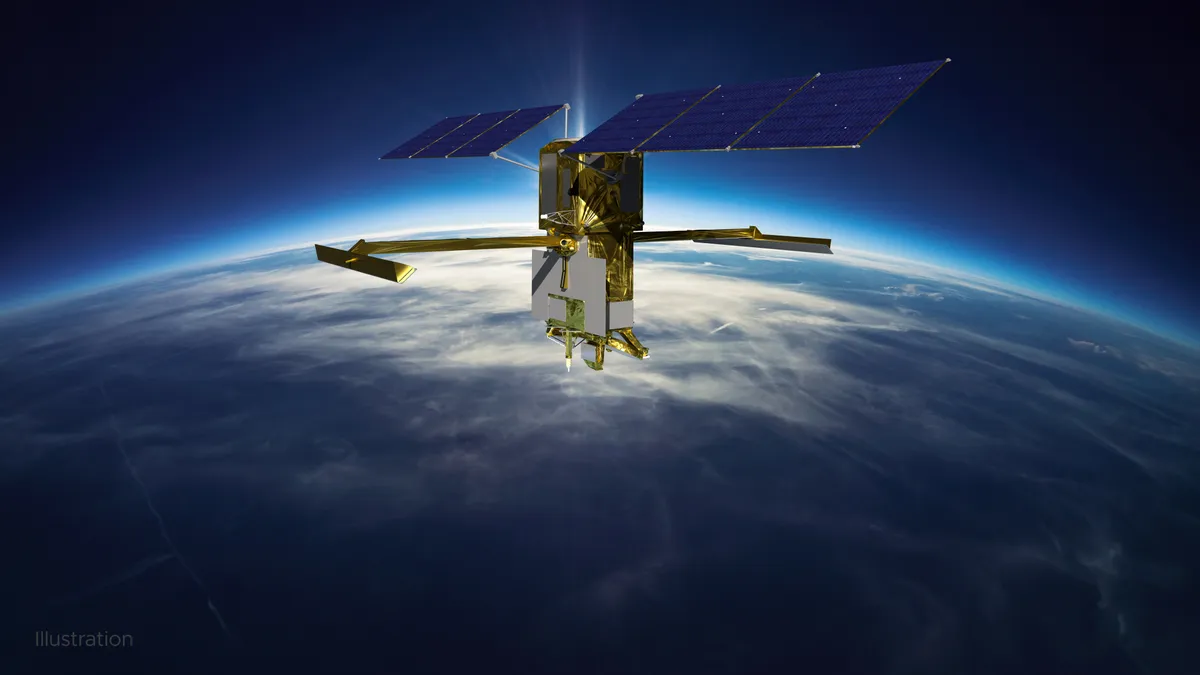
Before it can begin its mission of measuring the height of water over 90% of Earth's surface to provide scientists with the first-ever high-definition survey of our planet’s water SWOT had to deploy its large mast and antenna panels.
Related: NASA SWOT Earth water satellite a 'game changer' to fight climate change

The unfurling of its large mast and antenna panels was completed over four days, wrapping up on Dec. 22, and was captured by the SWOT's four customized commercial cameras.
In the video, the masts can be seen extending from opposite sides of the spacecraft, can be seen extending out from SWOT, and locking in place. Unfortunately, the recording stopped before the cameras could capture the antennas at the end of the masts fully unfolding. SWOT's operators confirmed this using telemetry data from the craft.
The spacecraft, which orbits Earth at an altitude of around 533 miles (857 kilometers), had already unfolded its solar panel arrays ensuring it receives a steady supply of power to operate. This array unfolding took place just after SWOT launched and took about 10 minutes and was also recorded by the spacecraft’s cameras.
The SWOT antennas are 33 feet (10 meters) apart and are part of the Ka-band Radar Interferometer (KaRIn) instrument. Not only will KaRIn observe and measure the height of water in Earth's freshwater bodies and the ocean the instrument will be able to see small-scale characteristics like eddies, currents, and other features less than 13 miles (20 kilometers) across.
KaRIn will also focus on Earth's bodies of water like lakes, rivers wider than 330 feet (100 meters) across, and even reservoirs that are larger around 62,500 square meters.
It collects data by bouncing radar pulses off the surface of Earth’s water and collecting the signals with its antennas. This data-collecting area sweeps out to around 30 miles (50 kilometers) from either side of SWOT.
Once fully operational NASA says that the data SWOT provides will assist scientists and politicians to address the pressing problem of climate change in order to help various communities prepare for a warmer climate and the challenges it will bring.
SWOT was jointly developed by NASA and Centre National D’Etudes Spatiales (CNES) with contributions from the Canadian Space Agency (CSA) and the U.K.’s Space Agency. First conceived in 2007, the spacecraft entered its fabrication stage in 2016.
"The SWOT mission brings together two communities focused on a better understanding of the world's oceans and its terrestrial surface waters," NASA wrote on its SWOT mission website. "U.S. and French oceanographers, hydrologists, and international partners have joined forces to develop this satellite mission to make the first global survey of Earth’s surface water, observe the fine details of the ocean's surface topography, and measure how water bodies change over time."
Follow us on Twitter @Spacedotcom or on Facebook.