As Hurricane Dorian Nears Florida, NASA Maps Storm Flooding in Bahamas
Just as satellites have played a crucial role in monitoring and forecasting hazards caused by the massive Hurricane Dorian, so too will they help affected areas rebuild.
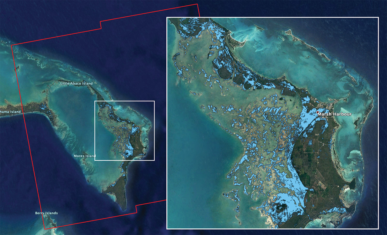
A team based at NASA's Jet Propulsion Laboratory in California is already building flood maps based on satellite data gathered over the Bahamas, parts of which were walloped by Hurricane Dorian for a full day.
In particular, the team drew on data gathered by the European Space Agency's Copernicus Sentinel-1 on Sept. 2, 2019. That program uses synthetic aperture radar instruments, which can detect changes in the ground.
In Photos: Hurricane Dorian from Space in Astronaut and Satellite Views
In the map built off this data, light blue shows flooding left by Dorian, with each single dot of color representing an area about 96 feet (30 meters) across, according to a NASA statement. Maps like these let emergency responders prioritize their actions now that the storm has finally moved on.
Hurricane Dorian is now crawling up the Florida coast and will reach Georgia tonight (Sept. 4) before continuing to progress up the eastern seaboard over the week, according to the National Oceanic and Atmospheric Administration's National Hurricane Center (NHC).
The NHC is currently predicting that the storm will reach North Carolina on Friday (Sept. 6), before continuing across the Atlantic toward Nova Scotia and Newfoundland.
Breaking space news, the latest updates on rocket launches, skywatching events and more!
If you live in the southeast or mid-Atlantic regions, follow the NHC and your local National Weather Service office for updated forecasts and warnings.
- NASA Sees Hurricane Dorian from Space Station (Video)
- NASA's Kennedy Space Center Prepares for Hurricane Dorian
- Photos: Most Powerful Storms of the Solar System
Email Meghan Bartels at mbartels@space.com or follow her @meghanbartels. Follow us on Twitter @Spacedotcom and on Facebook.

Meghan is a senior writer at Space.com and has more than five years' experience as a science journalist based in New York City. She joined Space.com in July 2018, with previous writing published in outlets including Newsweek and Audubon. Meghan earned an MA in science journalism from New York University and a BA in classics from Georgetown University, and in her free time she enjoys reading and visiting museums. Follow her on Twitter at @meghanbartels.

