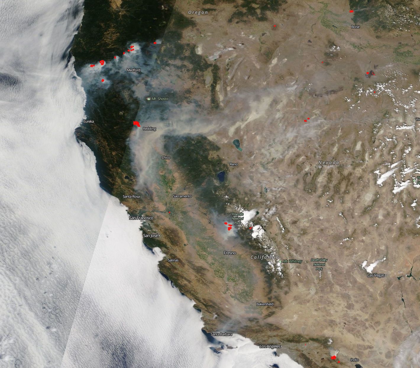
West Coast Wildfires Blaze in Satellite Photo

The severity and scope of the wildfire situation along the U.S. West Coast are on full display in a new satellite photo.
The image, captured Thursday (July 26) by NASA's Terra satellite, shows more than a dozen individual fires burning in Oregon, California, Nevada and Idaho.
"From Oregon and the fires around Medford, to the huge smoke plume and fire around Redding [California], to the Ferguson fire near Yosemite, the whole of the western coast looks like it is on fire," NASA officials wrote in a photo description. "There's even a small [fire] south of Los Angeles that can be seen at the very bottom edge of the image."
The blaze north of Redding, known as the Carr Fire, is particularly dangerous and fast-moving. The fire began Monday (July 23) and, as of yesterday (July 27), had burned more than 44,000 acres (17,800 hectares) and remained just 3 percent contained, according to the California Department of Forestry and Fire Protection (Cal Fire).
The Carr conflagration has killed two firefighters, according to media reports. It has also destroyed 65 structures, damaged 55 other buildings and put 5,000 additional structures under threat, a Cal Fire update states.
Terra launched to Earth orbit in December 1999. The satellite gathers a variety of data about our planet using five science instruments, including the Moderate-Resolution Imaging Spectroradiometer (MODIS).
MODIS' thermal bands allow scientists to spot a wildfire's actively burning areas, which are shown in red in the new photo. The instrument — which also flies aboard Terra's sibling satellite, Aqua — has helped researchers study, and emergency-response crews deal with, numerous wildfires over the years.
Breaking space news, the latest updates on rocket launches, skywatching events and more!
Follow Mike Wall on Twitter @michaeldwall and Google+. Follow us @Spacedotcom, Facebook or Google+. Originally published on Space.com.

Michael Wall is a Senior Space Writer with Space.com and joined the team in 2010. He primarily covers exoplanets, spaceflight and military space, but has been known to dabble in the space art beat. His book about the search for alien life, "Out There," was published on Nov. 13, 2018. Before becoming a science writer, Michael worked as a herpetologist and wildlife biologist. He has a Ph.D. in evolutionary biology from the University of Sydney, Australia, a bachelor's degree from the University of Arizona, and a graduate certificate in science writing from the University of California, Santa Cruz. To find out what his latest project is, you can follow Michael on Twitter.
