Watch Lightning Flashes from Space in These Mesmerizing Satellite Videos
Breaking space news, the latest updates on rocket launches, skywatching events and more!
You are now subscribed
Your newsletter sign-up was successful
Want to add more newsletters?
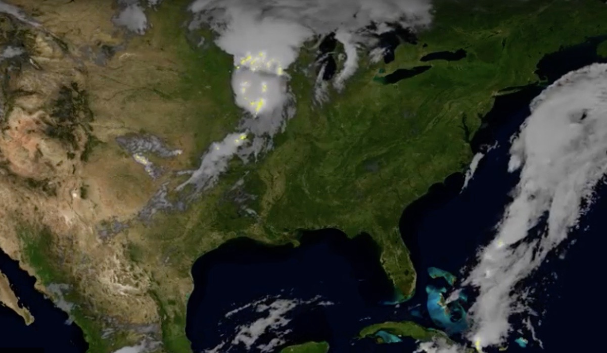
The Midwestern United States is ablaze with lightning in a striking new satellite video.
The May 9 footage is the "first-light" imagery captured by the Geostationary Lightning Mapper (GLM), an instrument aboard the National Oceanic and Atmospheric Administration's (NOAA) recently launched GOES-17 satellite.
"The mapper observes lightning in the Western Hemisphere, giving forecasters an indication of when a storm is forming, intensifying and becoming more dangerous," NOAA officials wrote Monday (May 21) in a description of the video. "Rapid increases of lightning are a signal that a storm may strengthen quickly and could produce severe weather."
GOES-17 launched on March 1 to geostationary orbit, about 22,300 miles (35,900 kilometers) above Earth. The satellite currently hovers just off the western coast of South America.
GOES-17 is in the midst of a six-month checkout period. When this is complete, the spacecraft will move about 50 degrees of longitude to the west — out to sea above the Pacific Ocean — and begin its planned 15-year mission, which involves tracking weather systems and a variety of environmental hazards here on Earth, as well as monitoring solar activity and space weather.
The satellite will then be officially known as GOES-West. GOES-West and its twin, GOES-East, which launched in 2016 and now hovers over the Americas, will together be able to monitor a huge swath of the globe, from New Zealand to the west coast of Africa, NOAA officials said. (Adding to the name confusion, GOES-17 was known as "GOES-S" before launch.)
"GOES" stands for "Geostationary Operational Environmental Satellites." The long-running, Earth-observing program is a collaboration between NOAA, which operates the satellites, and NASA, which oversees the crafts' design, manufacture and launch.
Breaking space news, the latest updates on rocket launches, skywatching events and more!
Follow Mike Wall on Twitter @michaeldwall and Google+. Follow us @Spacedotcom, Facebook or Google+. Originally published on Space.com.

Michael Wall is the Spaceflight and Tech Editor for Space.com and joined the team in 2010. He primarily covers human and robotic spaceflight, military space, and exoplanets, but has been known to dabble in the space art beat. His book about the search for alien life, "Out There," was published on Nov. 13, 2018. Before becoming a science writer, Michael worked as a herpetologist and wildlife biologist. He has a Ph.D. in evolutionary biology from the University of Sydney, Australia, a bachelor's degree from the University of Arizona, and a graduate certificate in science writing from the University of California, Santa Cruz. To find out what his latest project is, you can follow Michael on Twitter.

