Irma, Jose and Katia: 3 Atlantic Hurricanes As Seen from Space (Video)
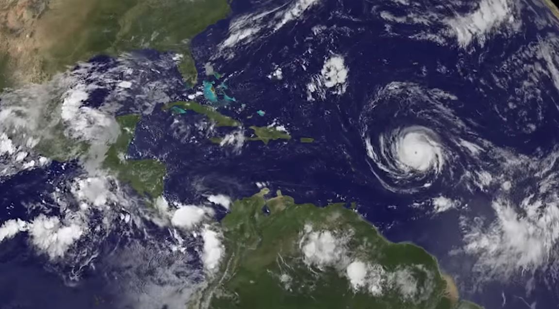
The National Oceanic and Atmospheric Administration's (NOAA's) GOES-13 satellite captured astonishing imagery of Hurricanes Irma, Jose and Katia forming over the course of several days.
As of Thursday morning, there's a startling total of three hurricanes in the Atlantic Ocean: Hurricane Irma in the Caribbean Sea, Hurricane Katia in the Gulf of Mexico and Hurricane Jose gaining power to the east of the Caribbean islands.
As the sunlight cycled between day and night Sept. 4-7, the satellite captured Katia and Jose as they developed, while the eye of Hurricane Irma remained ominously intact. [Best Hurricane Irma Apps: Track the Storm and Stay Safe]
- Hurricane Irma in Photos: Views from Space of a Monster Storm
- Here's How You Can Track Hurricane Irma Online
- See Hurricane Irma in Motion in These NASA and NOAA Gifs
On Sept. 6, Irma's Category 5 winds caused destruction to U.S. soil in the northeast Caribbean, on spots such as Puerto Rico and the U.S. Virgin Islands, and wreaked havoc to the island nations of Barbuda and St. Martin. NOAA stated on Thursday morning that Irma is traveling west-northwestward off the northern coast of Hispaniola — where the nations of the Dominican Republic and Haiti are located — at 17 mph (27 km/h), and carries 180-mph (290 km/h) winds as it makes its way to the Turks and Caicos Islands. Hurricane warnings are in effect for the state of Florida and the Florida Keys, which Irma will impact this weekend.
As of 5 a.m. EDT (0900 GMT) this morning, Hurricane Jose is growing in strength as it moves west-northwestward, carrying sustained winds of 90 mph (145 km/h). Hurricane Katia is actually stationary in the southwestern Gulf of Mexico, according to NOAA, and the storm's 80-mph (130 km/h) winds threaten the Mexican coastline between the cities of Tampico and Veracruz.
Follow Doris Elin Salazar on Twitter @salazar_elin. Follow us @Spacedotcom, Facebook and Google+. Original article on Space.com.
Breaking space news, the latest updates on rocket launches, skywatching events and more!

Doris is a science journalist and Space.com contributor. She received a B.A. in Sociology and Communications at Fordham University in New York City. Her first work was published in collaboration with London Mining Network, where her love of science writing was born. Her passion for astronomy started as a kid when she helped her sister build a model solar system in the Bronx. She got her first shot at astronomy writing as a Space.com editorial intern and continues to write about all things cosmic for the website. Doris has also written about microscopic plant life for Scientific American’s website and about whale calls for their print magazine. She has also written about ancient humans for Inverse, with stories ranging from how to recreate Pompeii’s cuisine to how to map the Polynesian expansion through genomics. She currently shares her home with two rabbits. Follow her on twitter at @salazar_elin.

