


Satellites are assessing the damage following a devastating earthquake affecting Turkey and numerous other countries on Monday (Feb. 6).
The magnitude 7.8 earthquake struck overnight in Turkey and Syria, flattening buildings and creating debris visible in satellite imagery from Planet, Maxar and other entities monitoring the region. Hours later, a second quake of magnitude 7.5 shook those countries. Both tremors were felt in nearby nations.
At least 11,200 people are reported dead in the wake of the disaster, according to Time, as a dangerous and urgent search for survivors continues. The first earthquake, the report added, was felt in regions as far afield as Lebanon, Cyprus, Greece, Israel and Palestine.
Related: Turkey earthquake prompts United Nations to activate emergency satellite mapping
This SkySat image captured today, Feb 7, 2023, shows major damage in central Kahramanmaraş, #Turkey in the aftermath of yesterday’s #earthquake. We'll continue to share updates on #satelliteimagery as it is collected. pic.twitter.com/lIp92HNljQFebruary 7, 2023
We are working with multiple organizations to provide them with #satelliteimagery of the recent #earthquake that has devastated #Turkey & #Syria. Seen here are before (Oct 4, 2022) & after (Feb 7, 2023) images of #Islahiye, Turkey, showing collapsed buildings & rescue operations. pic.twitter.com/3c69oZFYmuFebruary 7, 2023
Users on Twitter are also reviewing data available from the satellite providers and posting processed images.
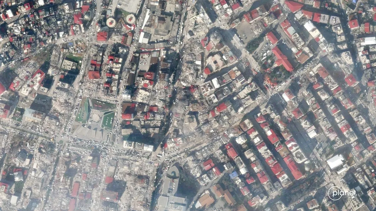
This is a running thread of satellite imagery showing the destruction seen in Turkey and Syria in the aftermath of the devastating earthquakes. #turkeyearthquake2023👇🧵 pic.twitter.com/EXPlRe5aO5February 8, 2023
Satellite imagery captured today by @planet now shows what appears to be two ruptured oil storage tanks at the Ceyhan terminal in Turkey. These tanks are fed with oil that derives from northern Iraq. Each one of these tanks can store a million barrels. #OOTT pic.twitter.com/DhnmvyWZQJFebruary 7, 2023
The International Space Station Expedition 68 crew has an orbit that brings it approximately 250 miles (400 kilometers) over Turkey. Japanese astronaut Koichi Wakata shared a picture on Twitter from their orbital perch on Wednesday (Feb. 8).
"Our thoughts and prayers are with the people in Turkey, Syria, and all the affected areas devastated by the earthquake," Wakata wrote.
Twitter accounts from NASA, the National Oceanic and Atmospheric Administration (NOAA) and the European Space Agency have not yet posted Turkey images, which may take several days for the agencies to collect depending on available satellite time, their orbits and cloud cover.
Our thoughts and prayers are with the people in Turkey, Syria, and all the affected areas devastated by the earthquake. pic.twitter.com/y2F2AodRk7February 8, 2023
Satellite imagery and orbital observations will be used alongside other data to help those coping with the disaster get resources where they are needed. A live map with geospatial data is available via the United Nations Satellite Centre website.
The center announced Monday on Twitter that it has activated its mapping service, which "provides satellite image analysis during humanitarian emergencies related to disasters, complex emergencies and conflict situations."
No satellites are directly operated by that center, but it does work with U.N. member states to gather imagery from their governmental agencies and private satellite operators. Maxar has pledged to provide imagery to "multiple organizations", while Planet said it is planning to provide more updates in the coming days.
Elizabeth Howell is the co-author of "Why Am I Taller?" (ECW Press, 2022; with Canadian astronaut Dave Williams), a book about space medicine. Follow her on Twitter @howellspace. Follow us on Twitter @Spacedotcom or Facebook.
