NASA satellites track California wildfire's smoke plumes and burn scars from space
Eight people are dead and thousands more affected by ongoing wildfires in California, which also forced the closure of the state's oldest park — Big Basin Redwoods State Park — for the season.
NASA is marshaling its resources and satellites to help the state deal with the lightning-induced natural disaster. Scientists have created maps and other data products to track the fires and smoke plumes and make predictions about which parts of California may be affected next, the agency said in a statement.
"When disasters like this occur, we are able to swiftly respond to requests from our partners who need images and mapping data," said David Green, manager of NASA's disasters program, in the statement. "Likewise, in the aftermath of the fires, our researchers will use orbital and aerial data of the burn areas to help mitigate hazards such as landslides and mudslides."
Related: California wildfire damage spotted from space (photos)
The NASA-led Aqua and Terra satellites are imaging the region through an instrument they both carry, called the Moderate Resolution Imaging Spectroradiometer (MODIS).
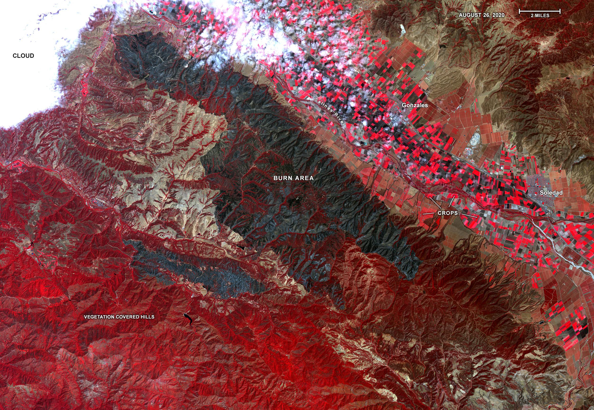
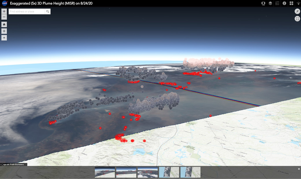
Two other Terra instruments are assisting with the effort, too: the Advanced Spaceborne Thermal Emission and Reflection Radiometer (ASTER) that monitors smoke and heat in visible, near-infrared and thermal-infrared wavelengths, and the Multi-angle Imaging SpectroRadiometer (MISR) that is looking at how high and far smoke particles travel.
Also keeping an eye on the wildfires are the Suomi-NPP satellite (operated by the National Oceanic and Atmospheric Administration or NOAA) and the CALIPSO satellite (a joint mission between NASA and the French national space agency, CNES).
Breaking space news, the latest updates on rocket launches, skywatching events and more!
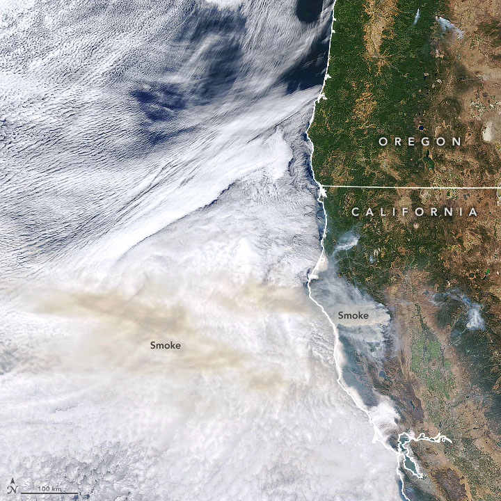
"The smoke plumes generated by the California fires have traveled across vast swaths of western North America in recent weeks, affecting air quality and visibility," NASA said in the statement. "Airborne smoke particles can increase the risk of cardiovascular and respiratory disease when inhaled, so tracking their spread provides valuable information for local public health officials."
Related: Why is wildfire smoke so bad for your lungs?
Drones and airplanes are also monitoring the fire's spread. NASA's Jet Propulsion Laboratory (JPL) in Pasadena, California is flying its Uninhabited Aerial Vehicle Synthetic Aperture Radar (UAVSAR) instrument over various fires in Monterey, San Mateo, Santa Cruz, Sonoma, Napa, Solano and Lake counties.
The instrument flies underneath a C-20A aircraft that is usually based at NASA's Armstrong Flight Research Center near Palmdale, California. It is commonly used to detect ground changes over specific areas, such as earthquake faults, and is being repurposed in this effort to look for burn scars.
"The instrument's radar signals bounce off vegetation in a different way than they do bare, freshly burned ground," NASA said in the statement.
"Accurately measuring the burn scar extent is important to assessing the long-term effects of fire damage. A loss of vegetation on hillsides can put an area at risk of mudslides during rainstorms. In combination with other science instruments, the findings of these UAVSAR flyovers can help characterize the spread of active fires while allowing a better understanding of their longer-term effects."
Along with UAVSAR, JPL is flying a short-wavelength infrared imager to look at fires at the same time that UAVSAR looks at the smoke, to better understand the effect of the fires on the various regions of California.
Follow Elizabeth Howell on Twitter @howellspace. Follow us on Twitter @Spacedotcom and on Facebook.

Elizabeth Howell (she/her), Ph.D., was a staff writer in the spaceflight channel between 2022 and 2024 specializing in Canadian space news. She was contributing writer for Space.com for 10 years from 2012 to 2024. Elizabeth's reporting includes multiple exclusives with the White House, leading world coverage about a lost-and-found space tomato on the International Space Station, witnessing five human spaceflight launches on two continents, flying parabolic, working inside a spacesuit, and participating in a simulated Mars mission. Her latest book, "Why Am I Taller?" (ECW Press, 2022) is co-written with astronaut Dave Williams.


