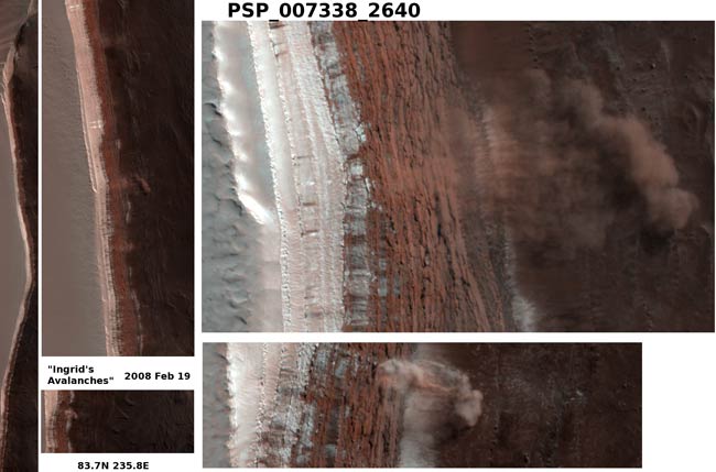
Avalanche Photographed on Mars

A NASAspacecraft has taken the first-ever image of an avalanche in action near Mars'north pole.
The HighResolution Imaging Experiment (HiRISE) on NASA's Mars Reconnaissance Orbitertook the photograph Feb. 19. The image, released today, shows tan clouds billowing away from thefoot of a towering slope, where ice and dust have just cascaded down.
The camerawas tracking seasonal changes on Marswhen it inadvertently caught the avalanche on film.
HiRISEmission scientist Ingrid Daubar Spitale of the University of Arizona was the first person to notice the avalanche when sifting through images.
"Itreally surprised me," she said. "It's great to see something sodynamic on Mars. A lot of what we see there hasn't changed for millions ofyears."
The fullimage reveals features as small as a desk in a strip of terrain 3.7 miles (6kilometers) wide and more than 10 times that long, at 84 degrees northlatitude. Reddish layers known to be rich in water ice make up the face of asteep slope more than 2,300 feet (700 meters) tall, running the length of theimage.
Thescientists suspect that moreice than dust probably makes up the material that fell from the upperportion of the scarp.
Breaking space news, the latest updates on rocket launches, skywatching events and more!
"Ifblocks of ice broke loose and fell, we expect the water in them will bechanging from solid to gas," said Patrick Russell of the University ofBerne, Switzerland, a HiRISE team collaborator. "We'll be watching to seeif blocks and other debris shrink in size. What we learn could give us a betterunderstanding of one part of the water cycle on Mars."
What setoff the landslide and whether such events are common on Mars is something elsethe team will be looking at.
"Wedon't know what set off these landslides," Russell said. "We plan totake more images of the site through the changing Martian seasons to see ifthis kind of avalanche happens all year or is restricted to early spring."
- Video: All Eyes on Mars
- Vote: The Best of the Mars Rovers!
- Visualizations of Mars
Join our Space Forums to keep talking space on the latest missions, night sky and more! And if you have a news tip, correction or comment, let us know at: community@space.com.

Space.com is the premier source of space exploration, innovation and astronomy news, chronicling (and celebrating) humanity's ongoing expansion across the final frontier. Originally founded in 1999, Space.com is, and always has been, the passion of writers and editors who are space fans and also trained journalists. Our current news team consists of Editor-in-Chief Tariq Malik; Editor Hanneke Weitering, Senior Space Writer Mike Wall; Senior Writer Meghan Bartels; Senior Writer Chelsea Gohd, Senior Writer Tereza Pultarova and Staff Writer Alexander Cox, focusing on e-commerce. Senior Producer Steve Spaleta oversees our space videos, with Diana Whitcroft as our Social Media Editor.
