See the Spring Snowstorm Over the US Northeast in These Satellite Views
Breaking space news, the latest updates on rocket launches, skywatching events and more!
You are now subscribed
Your newsletter sign-up was successful
Want to add more newsletters?

Delivered daily
Daily Newsletter
Breaking space news, the latest updates on rocket launches, skywatching events and more!

Once a month
Watch This Space
Sign up to our monthly entertainment newsletter to keep up with all our coverage of the latest sci-fi and space movies, tv shows, games and books.

Once a week
Night Sky This Week
Discover this week's must-see night sky events, moon phases, and stunning astrophotos. Sign up for our skywatching newsletter and explore the universe with us!

Twice a month
Strange New Words
Space.com's Sci-Fi Reader's Club. Read a sci-fi short story every month and join a virtual community of fellow science fiction fans!
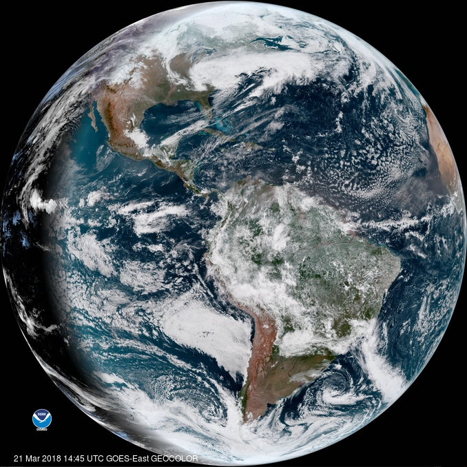
A massive storm is expected to dump more than a foot of snow in some states along the northeastern U.S. coast, and satellites are tracking the snowfall from space.
The GOES-East satellite, operated by the National Oceanic and Atmospheric Administration (NOAA), has captured stunning views of the storm over the mid-Atlantic coastal region, showing a blanket of white over much of the area. [Amazing Earth Photos by GOES East]
"It's a #snowday in the nation's capital captured here by #GOESEast," NOAA officials wrote on Twitter in a post that included a video of the storm system in action. Conditions in the Baltimore area were expected to deteriorate rapidly over the morning, with some regions receiving 2 inches (5 centimeters) of snow per hour, NOAA officials added.
Another short animation from GOES-East showed the storm engulfing states from North Carolina up to Massachusetts.
"#GOESEast captures the start of the storms affecting parts of the East Coast and expected to bring heavy snow to the start of Spring," NOAA officials wrote.
The National Weather Service has issued a winter storm warning through Thursday morning (March 22) due to today's snowstorm, which is the fourth nor'easter to hit the U.S. East Coast in March. Some regions could see between 12 and 18 inches (30 to 46 cm) of snow, according to the National Weather Service.
The GOES-East satellite, also called GOES-16, launched in 2016 and is the first of two advanced Earth-observation satellites to improve weather forecasts. Its partner, the GOES-S satellite, launched into orbit on March 1 and will be known as GOES-West and GOES-17 when it begins operation. GOES is short for "Geostationary Operational Environmental Satellite."
Breaking space news, the latest updates on rocket launches, skywatching events and more!
Email Tariq Malik at tmalik@space.com or follow him @tariqjmalik. Follow us @Spacedotcom, Facebook and Google+. Original article on Space.com.

Tariq is the award-winning Editor-in-Chief of Space.com and joined the team in 2001. He covers human spaceflight, as well as skywatching and entertainment. He became Space.com's Editor-in-Chief in 2019. Before joining Space.com, Tariq was a staff reporter for The Los Angeles Times covering education and city beats in La Habra, Fullerton and Huntington Beach. He's a recipient of the 2022 Harry Kolcum Award for excellence in space reporting and the 2025 Space Pioneer Award from the National Space Society. He is an Eagle Scout and Space Camp alum with journalism degrees from the USC and NYU. You can find Tariq at Space.com and as the co-host to the This Week In Space podcast on the TWiT network. To see his latest project, you can follow Tariq on Twitter @tariqjmalik.

