1966 Lunar Orbiter Photo of Earth and Moon

The unmanned Lunar Orbiter missions in 1966 and 1967 prepared the ground for Apollo by mapping the surface of the moon from space. One byproduct of this is a remarkable series of photos, such as this image, from Lunar Orbiter I, which are the first pictures of the Earth taken from beyond the moon. [Read the Full Story Here]
Reprocessed 1966 Lunar Orbiter Photo of Earth and Moon

The unmanned Lunar Orbiter missions in 1966 and 1967 prepared the ground for Apollo by mapping the surface of the moon from space. One byproduct of this is a remarkable series of photos, such as this image, from Lunar Orbiter I, which are the first pictures of the Earth taken from beyond the moon. In 2008, NASA reprocessed and re-released this image. The scanlines disappear, and the contrast and resolution are dramatically improved. [Read the Full Story Here]
Mars in 1976: Ascraeus Mons from Viking 1 Orbiter

Viking 1 and 2, both of which landed in 1976, returned the first useable data from the planet's surface, as well as providing further mapping from their respective orbiters. The image shows Ascraeus Mons, an extinct volcano more than twice as high as Mount Everest, which had been discovered by Mariner 9 a few years earlier. [Read the Full Story Here]
Jupiter's Moons in 1979: Io by Voyager 1

This image shows Jupiter moon Io taken by Voyager 1 in 1979. Voyager probes 1 and 2 visited the Jovian system in 1979, before taking different paths through the outer reaches of the Solar System, studying the giant planet as well as making numerous images of its moons. The relatively narrow field of view, combined with the Voyager probes' close flybys meant that the photos had to be stitched together, which in the days before powerful computer graphics software meant printing them out and sticking them together by hand, like a giant jigsaw puzzle, interspersed with hand-written notes and computer printouts of technical information relating to the photographs. [Read the Full Story Here]
Mars in 1972: Oxia Palus from Mariner 9

Mariner 9, a NASA probe in 1971-2, was the first to orbit the red planet, rather than fly-by, and produced what were, for the time, remarkably detailed maps of the planet. This image of the Oxia Palus Quadrangle, taken by Mariner 9, shows a large area of Mar’s surface. The horizontal extent of the map is a full quarter of the planet's circumference, while the vertical axis runs from the equator (the bottom edge of the map) one third of the way towards the planet's North Pole. The Oxia Palus Quadrangle is one of 30 regions that NASA split Mars into for the purpose of mapping. [Read the Full Story Here]
Jupiter's Moons in 1979: Ganymede by Voyager 2

This image shows Jupiter moon Ganymede taken by Voyager 2 in 1979. Voyager probes 1 and 2 visited the Jovian system in 1979, before taking different paths through the outer reaches of the Solar System, studying the giant planet as well as making numerous images of its moons. The relatively narrow field of view, combined with the Voyager probes' close flybys meant that the photos had to be stitched together, which in the days before powerful computer graphics software meant printing them out and sticking them together by hand, like a giant jigsaw puzzle, interspersed with hand-written notes and computer printouts of technical information relating to the photographs. [Read the Full Story Here]
Venus in 1982: Venera 13

This is an image of Venus from Soviet Venera program probe Venera 13 taken in 1982. The Cyrillic text below the pictures reads: “Venera 13 brabotka IPPI AN SSSR TsDKS,”short for “Venera 13, Processing, Institute for Problems in Transmitting Information, Academy of Sciences, Union of Soviet Socialist Republics, Centre for Long-Distance Space Communications.” [Read the Full Story Here]
Venus in 1982: Venera 14
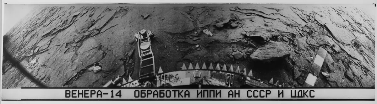
This is an image of Venus from Soviet Venera program probe Venera 14 taken in 1982. The Cyrillic text below the pictures reads: “Venera 14 brabotka IPPI AN SSSR TsDKS,”short for “Venera 14, Processing, Institute for Problems in Transmitting Information, Academy of Sciences, Union of Soviet Socialist Republics, Centre for Long-Distance Space Communications.” [Read the Full Story Here]
Venera Synthetic Aperture Radar Map

This is an image of an aperture radar map taken by a Soviet Venera probe. The text beneath the map reads: “Photomap. Page 14. Lambert conformal conic projection - Gauss. Standard parallels, 43.10 by 57.15. Reading height from a sphere of a radius 6051 km. Countour interval 0.5 km.” The surface of Venus cannot be photographed from space because of the planet's thick atmosphere and opaque clouds, leaving radar as the only way of imaging the surface without landing. [Read the Full Story Here]
Walter Goodacre’s 1910 Map of the Moon Publication Cover

This image shows the cover of the 1910 map of the moon publication by Walter Goodacre. Goodacre’s map of the moon is astonishingly detailed, and gives a glimpse back into the days when astronomy was not done with computers, spectrometers and CCD chips, but with human eyes, pens, paper, and the occasional piece of photographic film. Walter Goodacre was president of the Lunar section of the British Astronomical Association (the UK’s main amateur astronomy club) for forty years in the early 20th century. In that time, he prepared an incredibly detailed map of the moon, 70 inches (1.78 metres) across, which he published in book form in 1910. [Read the Full Story Here]
Goodacre’s 1910 Map of the Moon: Section 1

This image shows Section 1 of the 1910 map of the moon publication by Walter Goodacre. Goodacre’s map of the moon is astonishingly detailed, and gives a glimpse back into the days when astronomy was not done with computers, spectrometers and CCD chips, but with human eyes, pens, paper, and the occasional piece of photographic film. [Read the Full Story Here]
