China Launches Earth-Observing Satellite for Venezuela

China Launches Venuzuelan Satellite
China launched Venezuela's second satellite on Saturday, Sept. 29, 2012, delivering a spacecraft to monitor the country's territory, survey crops and natural resources, and aid Venezuela's security services. (Image credit: CGWIC)

China launched Venezuela's second satellite on Saturday (Sept. 29), delivering the spacecraft into a 400-mile-high orbit to monitor the country's territory, survey crops and natural resources, and aid Venezuela's security services.

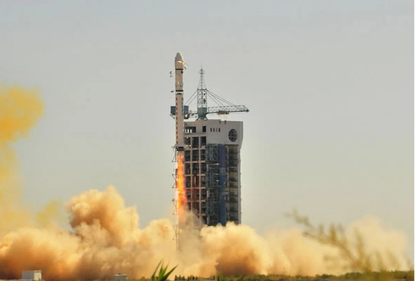
The satellite lifted off from the Jiuquan space center in northwest China at 12:12 a.m. EDT (0412 GMT; 12:12 p.m. Beijing time) atop a Long March 2D rocket. The two-stage launcher deployed the Venezuelan Remote Sensing Satellite, or VRSS 1, into orbit less than 13 minutes later.

Venezuelan state television broadcasted the launch live, showing President Hugo Chavez and aides applauding as the rocket soared into space.

Tracking data show the spacecraft is orbiting nearly 400 miles (644 kilometers) high with an inclination of 98 degrees.

China is delivering the VRSS 1 satellite to its customer in orbit under a contract signed with the government of Venezuela in May 2011.

VRSS 1 is the first remote sensing satellite China has delivered in orbit to an international customer.

The satellite was built by China Academy of Space Technology, and the launch was arranged by China Great Wall Industry Corp., the state-owned firm responsible for commercial Long March rocket missions.

VRSS 1 is Venezuela's second satellite built by China, which launched a communications satellite named Venesat 1 in 2008.

Venezuelan state media reported the VRSS 1 project cost about $140 million.

The satellite was named after Francisco de Miranda, a Venezuelan revolutionary hero. Venesat 1 was nicknamed Simon Bolivar, after the leader of Venezuela's struggle for independence.

The Miranda satellite will assess Venezuela's soil and water resources, collect images to help urban planners, monitor illegal mining and drug activities, and strengthen national defense, according to Venezuelan state television.

The craft's sensors can resolve objects 8.2 feet (2.5 meters) across. The satellite will return 350 images per day during its five-year mission, according to Jorge Arreaza, Venezuela's minister for science, technology and innovation.

The Miranda satellite will collect its first image around Oct. 10, a posting on a Venezuelan government website said.

VRSS 1 will be operated by the Bolivarian Agency for Space Activities on behalf of the Venezuelan government.

Copyright 2012 SpaceflightNow.com, all rights reserved.

Join our Space Forums to keep talking space on the latest missions, night sky and more! And if you have a news tip, correction or comment, let us know at: community@space.com.

Spaceflightnow.com Editor

Stephen Clark is the Editor of Spaceflight Now, a web-based publication dedicated to covering rocket launches, human spaceflight and exploration. He joined the Spaceflight Now team in 2009 and previously wrote as a senior reporter with the Daily Texan. You can follow Stephen's latest project at SpaceflightNow.com and on Twitter.