Earth-observation satellites continue to assess the vast damage in Turkey and Syria caused by the devastating series of earthquakes that struck on Feb. 6.
New images from the U.S. Earth-observation company Maxar Technologies show surface cracks that appeared when three lithospheric plates that meet in the affected region — the Anatolian, Arabian and African plates — collided on that fateful Monday.
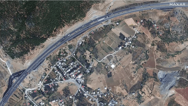
In one of these images, a surface fissure crosses the Turkish city of Nurdagi, where thousands of people have perished underneath collapsed buildings. Maxar satellites also caught a glimpse of the rupture near the city of Türkoğlu, about 20 miles (32 kilometers) north of Nurdagi, where the crack is visible across a distance of several miles.
Related: Turkey earthquake devastation spotted by satellites (photos)
Images captured by researchers and eyewitnesses on the ground are a testimony to the enormous power unleashed by the series of earthquakes that peaked with two temblors that registered at 7.8 and 7.5 on the Richter scale, respectively.
An image shared on Twitter by U.S.-based geologist Shreya Arora reveals a cliff-like edge splitting what previously had been a smooth snow-covered slope.
Left image: surface rupture of #turkey #earthquake Mw 7.8 Right image: surface rupture of #Kaikoura #earthquake Mw 7.8 pic.twitter.com/jgTwTvHP6xFebruary 13, 2023
The earthquakes, the worst in decades for the tectonically treacherous region around the Turkish-Syrian border, have killed over 37,000 people so far and made tens of thousands of others homeless. Rescue operations are proceeding slowly, especially on the Syrian side of the border, where relief efforts are complicated by a years-long civil war.
NEW: @Maxar’s satellite imagery clearly reveals the multi-km-long surface rupture extending along the Gölbaşı-Türkoğlu segment of the East Anatolian Fault as a result of the 7.8 magnitude earthquake in southern Turkey. pic.twitter.com/915oWD9b1EFebruary 13, 2023
European Earth-observing satellites previously revealed that the two fissures split open by the two main tremors last week are among the longest ever seen, professor Tim Wright, who leads the U.K. Centre for the Observation & Modelling of Earthquakes, Volcanoes & Tectonics, told Space.com last week.
The longer fissure, produced by the first, more powerful 7.8-magnitude earthquake, stretches 190 miles (300 km) northeast from the northeastern tip of the Mediterranean Sea. The shorter, 80-mile-long (125 km) crack, opened by the second, somewhat milder tremor, runs from west to east, partly in parallel with a section of the first fissure.
The images showed that the ground moved by up to 16 feet (5 meters) in some parts of the fissure.
Follow Tereza Pultarova on Twitter @TerezaPultarova. Follow us on Twitter @Spacedotcom and on Facebook.