With climate change continuing to affect our planet and mitigating measures lagging, 2023 has been another eventful year for Earth. Broken records, unparalleled weather disasters and some concerning studies have made the headlines this year. Here are some of the most significant stories about planet Earth in 2023.
1. Hottest summer on record
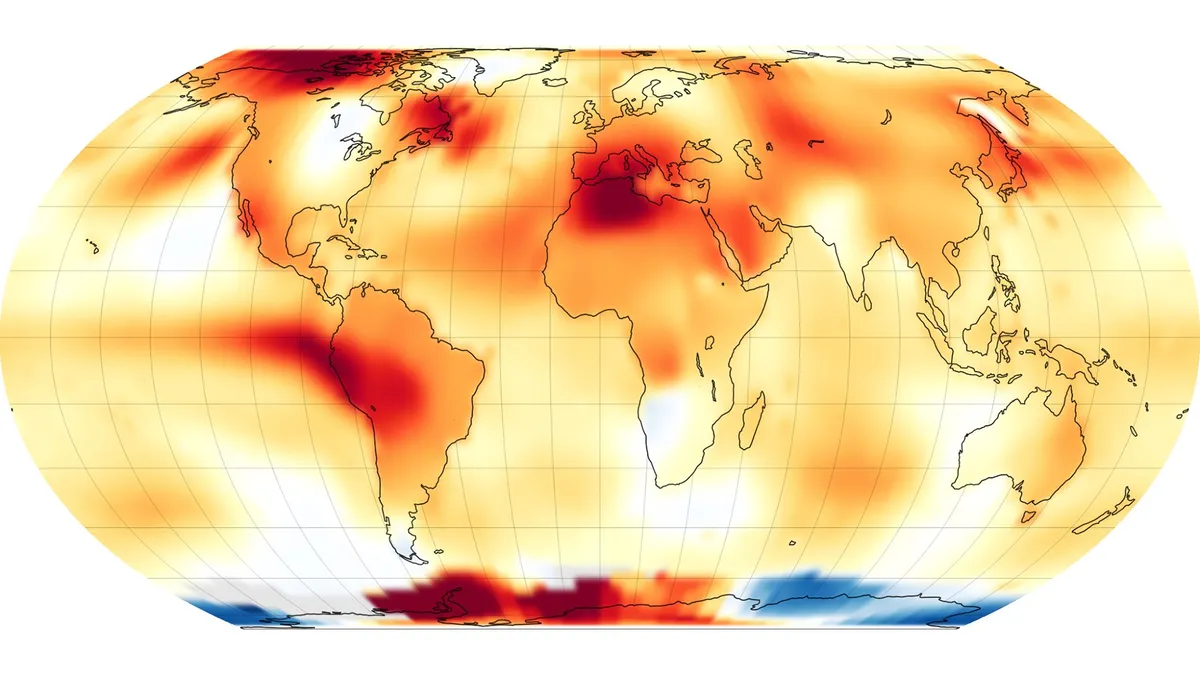
The summer of 2023 was the hottest summer since records began in 1880, NASA announced in September. Global warming, fueled by rising concentrations of greenhouse gases in Earth's atmosphere, received an extra boost this year from El Niño, a climate pattern that affects the distribution of warm seawater in the Pacific Ocean and thus the precipitation and temperatures all over the world.
Globally, August was 2.2 degrees Fahrenheit (1.2 degrees Celsius) warmer than average for August, and the period between June and August was 0.41 F (0.23 C) warmer than the average of all previous summers on record, NASA said.
The Northern Hemisphere summer saw extreme fires across Canada, record-breaking temperatures in the Atlantic Ocean and relentless heat waves in the southern U.S. and southern Europe. Scientists warn that as climate change progresses, such extreme weather events will become increasingly commonplace.
Read more here: This was the hottest summer ever recorded on Earth
2. Devastating Maui wildfire
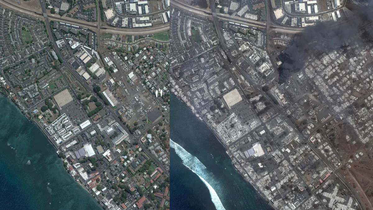
One of the most shocking wildfires of the 2023 Northern Hemisphere summer was the one that virtually erased the town of Lahaina, a historical settlement on Maui, Hawaii.
The blaze, which erupted on the drought-stricken island in the second week of August, spread at an unprecedented speed, fanned by winds from the passing Hurricane Dora. Nearly 100 people died in the inferno, and thousands of buildings turned to ash, including Lahaina's Old Courthouse and an early-19th-century church.
Read more here: Aftermath of Hawaii's deadly wildfire inferno revealed in gut-wrenching satellite images
3. Return of El Niño
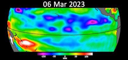
The warming El Niño climate pattern developed in the Pacific Ocean this year after seven cooler years, adding more fuel to Earth's warming ecosystem, which is already plagued by extreme weather events.
El Niño usually lasts about nine to 12 months and alternates with the cooling pattern called La Niña. Meteorologists declare El Niño conditions when sea temperatures in the tropical eastern Pacific rise by 0.9 F (0.5 C) above the long-term average, according to the U.K. Met Office, and that threshold was reached in early July.
Read more here: El Niño is officially here and may cause temperature spikes and major weather events
4. Possible shutdown of key ocean current system
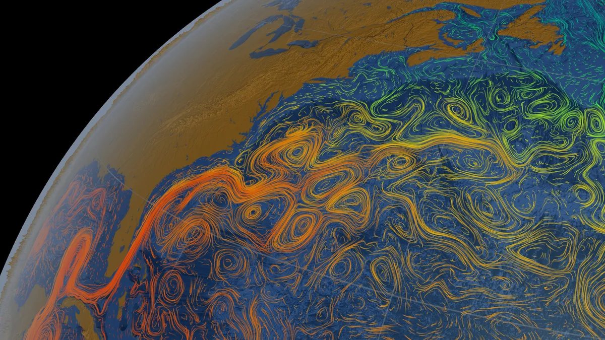
An ocean circulation pattern that includes the Gulf Stream, which famously carries warm water from the Caribbean to Europe, could shut down as early as 2025, researchers suggested in July.
Previous studies suggested that the ocean current system, known as the Atlantic Meridional Overturning Circulation (AMOC), is weakening, fueled by rising ocean temperatures resulting from global warming. The Intergovernmental Panel on Climate Change previously said it didn't expect the AMOC to totally switch off within this century, but the new study challenges that conclusion.
Although the results are far from certain, if they are correct, the effect would have a dramatic impact. Europe, especially, would suffer an extreme climate swing in the absence of the warming Gulf Stream. Apart from a frostier Europe, the system's shutdown would accelerate the temperature rise in the tropics and possibly disrupt tropical rain patterns, leading to unforeseen climate alterations in the tropics.
Read more here: Ocean current system could shut down as early as 2025, leading to climate disaster
5. Record-low sea ice extent in Antarctica
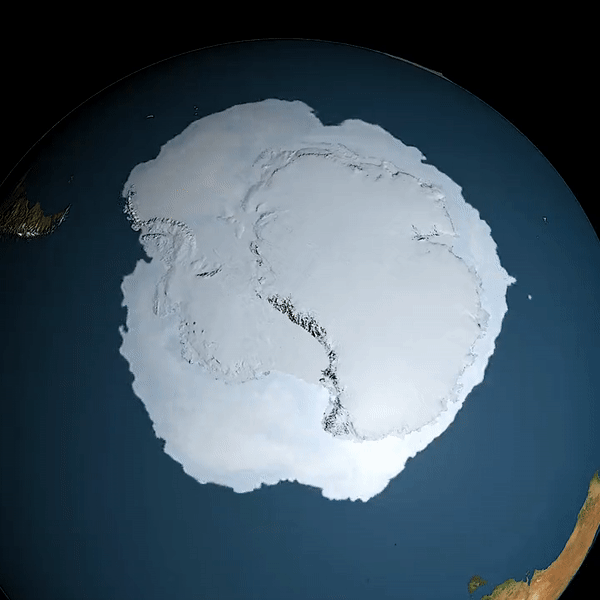
For many years, Antarctica seemed to hold quite steady against progressing climate change. But 2023 showed that the southern polar ice cap is not immune to the effects of rising temperatures. Satellites flying over Antarctica during the peak of the Antarctic summer in late 2022 and early 2023 showed that the extent of floating sea ice surrounding the continent had shrunk to an all-time low.
In February, only 66% of the area usually covered with sea ice in that part of the year was frozen over. As Antarctica moved toward its autumn and then winter months, the sea ice failed to replenish to its usual level. In September, just after the peak of the southern winter, researchers reported a record-low maximum annual sea ice extent.
That's bad news for the planet, as Antarctica plays an important role in maintaining Earth's climate equilibrium. Biologists are especially concerned about the fate of many animal species adapted to Antarctica's harsh climate. In August, researchers from the British Antarctic Survey reported that several Emperor penguin colonies lost all of their chicks, as sea ice melted too early in the season.
Read more here: Antarctic sea ice hits record low, satellites reveal
6. Smoke from Canadian wildfires

Smoke from widespread wildfires in eastern Canada delivered an unpleasant surprise to inhabitants of the U.S. East Coast in June. For a few days, New York and Philadelphia topped the list of the world's most polluted cities, which is usually dominated by Asian metropolises.
The ash particles suspended in the air produced beautiful — yet very toxic — sunsets, which residents were recommended to enjoy only from behind closed windows. The smoke plumes had been funneled from the Canadian provinces of Quebec and Nova Scotia by a low-pressure system that produced steady southeasterly winds.
The smog was so thick that it obscured the view of Earth-observing satellites imaging the planet from hundreds of miles above.
Read more here: Canadian wildfire smoke dims the vision of Earth-observing satellites (photos)
7. Changes to the tilt of Earth's axis
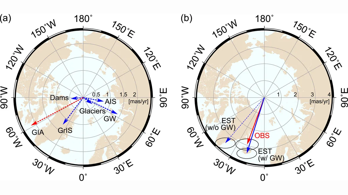
The tilt of Earth's rotational axis is changing because of human activity, scientists discovered this year. The extraction of groundwater between 1993 and 2010 caused a 31.5-inch (80 centimeters) shift in the axis's angle toward the plane in which the planet orbits. In that period, humans pumped out 2,150 gigatons of water from within the planet's crust. If such an amount were poured into the global ocean, its surface would rise by 0.24 inch (6 millimeters).
Scientists have known since 2016 that processes related to climate change, such as the thawing of icebergs, affect Earth's tilt, but it wasn't until they added the pumped-out water into their equations that the math matched the observations.
Read more here: Humans are pumping out so much groundwater that it's changing Earth's tilt
8. A brand-new island
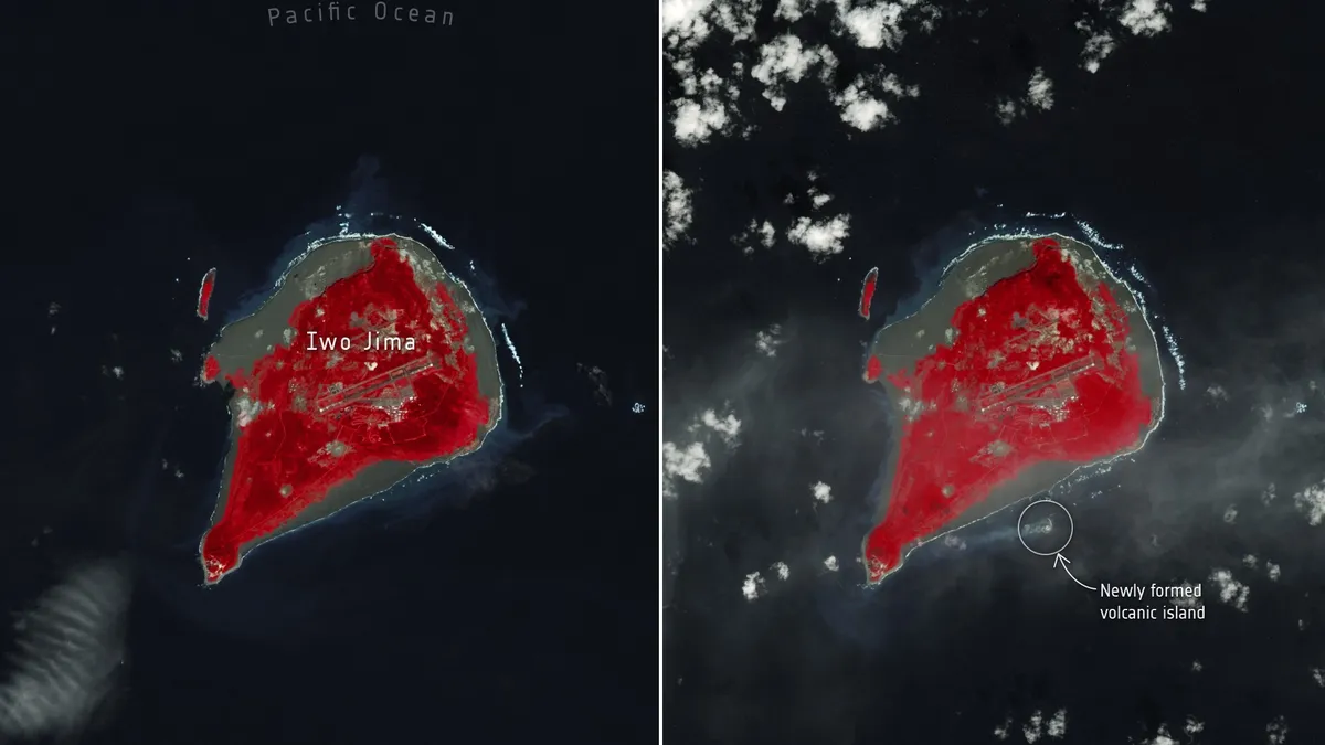
A new island formed off the coast of Japan in October after an undersea volcano erupted near the island of Iwo Jima some 750 miles (1,200 kilometers) south of Tokyo. The eruption hurled chunks of rock as large as 160 feet (50 meters) into the air. These fragments eventually piled together, creating the new island, which, at 330 feet (100 m) wide, can be clearly seen in satellite images. This new island is embedded in volcanic pumice about a mile (1.6 km) from Iwo Jima's coast.
Read more here: A volcanic eruption gave birth to a new island, and a NASA satellite saw it from space (photo)
9. Giant crack in Earth's crust

The devastating earthquake that hit Turkey and Syria in early February opened a 190-mile-long (300 km) fissure in Earth's crust, which can be detected by satellites from space. Such ruptures, caused by the movement of tectonic plates, are common after powerful temblors. But the one opened by the two 7.8 and 7.5 magnitude quakes, which hit the region in quick succession in the early hours of Feb. 6, stands out.
The crack's length is a testament to the enormous amount of energy the earthquakes unleashed as they destroyed towns and villages in an area the size of Germany. The earthquakes, the deadliest in Turkish history, killed nearly 60,000 people in Turkey and over 8,000 in Syria, and left about 1.5 million people homeless.
Read more here: Turkey earthquake opened 190-mile-long fissure, satellite images show
10. World's-largest iceberg on the move
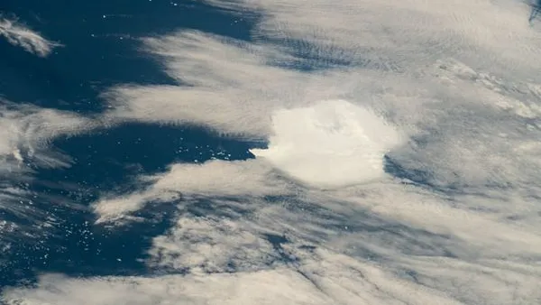
This fall, a European satellite captured images showing that the world's largest iceberg had broken loose from the coast of Antarctica and is drifting eastward along the frozen continent's coast. The 1,500-square-mile (4,000 square kilometers) iceberg, called A23a, separated from Antarctica's Filchner Ice Shelf in 1986 but remained stuck at the bottom of the Weddell Sea for nearly four decades.
Scientists don't know what set the iceberg adrift, but they think it may have thinned due to thawing and become lighter and, therefore, more buoyant. Using satellites, researchers can track the iceberg's progress and observe as it moves at about 3 miles (5 km) per day, carried by strong winds and ocean currents. A23a weighs nearly a trillion tons and is roughly three times the size of New York City.
Read more here: Satellites watch world's largest iceberg break away from Antarctica (photos)