NASA's next Mars rover, Perseverance, will explore the Red Planet with the aid of some of the most precise Martian maps ever created.
Perseverance, the centerpiece of NASA's $2.7 billion Mars 2020 mission, is scheduled to launch from Florida's Cape Canaveral Air Force Station on Thursday morning (July 30). If all goes according to plan, the car-sized rover will touch down inside Mars' Jezero Crater on Feb. 18, 2021.
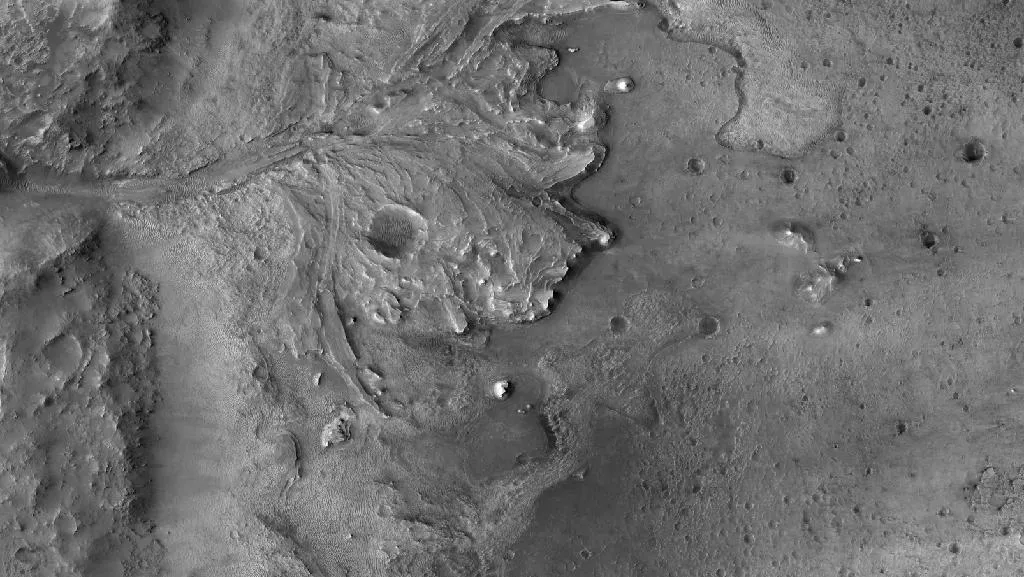
The 28-mile-wide (45 kilometers) Jezero hosted a lake and a river delta in the ancient past, making it an ideal destination for the life-hunting, sample-caching Perseverance. Ideal scientifically, anyway. The crater is covered in rough and rugged terrain, especially in the delta region so enticing to mission researchers, posing a challenge for the engineers tasked with getting the six-wheeled robot down safely.
Related: NASA's Mars Perseverance rover mission to the Red Planet (photos)
Mars 2020 will meet that challenge with the help of several new technologies. One of the most important is Terrain-Relative Navigation (TRN), which will allow the mission's sky-crane descent stage to assess the Jezero landscape for hazards during its landing approach and change course autonomously if need be.
That's where the groundbreaking cartography comes in. Mars 2020 will take advantage of two maps that United States Geological Survey (USGS) researchers created using imagery captured by NASA's Mars Reconnaissance Orbiter.

Detailed and aligned Mars maps
One map, which boasts a resolution of 10 inches (25 centimeters) per pixel, pinpoints hazards at the landing site near Jezero's ancient delta (and will also serve as the base map for mission operations). The other is a more traditional surface-structure map with a resolution of about 20 feet (6 meters) per pixel.
Mars 2020 will snap photos of the Jezero landscape as it descends through the Red Planet sky next February. Its onboard TRN system will then compare this imagery to the precisely aligned maps, in a manner similar to that employed by facial-recognition software.
"It can then identify, 'Are we going to be landing on a red pixel?' and, if we are, fire its retrorockets and navigate to the closest green pixel possible," Robin Fergason, a research geophysicist at the USGS' Astrogeology Science Center in Flagstaff, Arizona, told Space.com.
Mars 2020 must make such decisions on its own, without any help from its human handlers. The Red Planet will be about 130 million miles (209 million km) from Earth on landing day, meaning it will take more than 11 minutes for a signal from mission control to reach Perseverance. The rover's entire entry, descent and landing (EDL) sequence will last just 7 minutes.
TRN should help make Mars 2020's "7 minutes of terror" a bit less terrifying.
"If we didn't have Terrain-Relative Navigation, the probability of landing safely at Jezero Crater is about 80 to 85%. But with Mars 2020, we can actually bring that probability of success of landing safely at Jezero Crater all the way up to 99% safe every single time," Mars 2020 guidance and control engineer Swati Mohan, of NASA's Jet Propulsion Laboratory (JPL) in Pasadena, California, said in a 2019 NASA video about TRN. (JPL built Perseverance, developed its TRN system and will manage mission operations on the Red Planet.)
If you're surprised that the USGS is playing a key role in this Mars mission, you shouldn't be; the agency has produced detailed maps of off-Earth locales for decades. For example, the Astrogeology Science Center was established in 1963 to map the lunar surface ahead of NASA's Apollo missions and help train astronauts for their coming moonwalks. (The facility was known as the Flagstaff Science Center in those early days.)
"There's a long history there that's extended all the way to today," USGS director Jim Reilly, a former NASA astronaut with three space shuttle missions under his belt, told Space.com.
Related: NASA's 17 Apollo moon missions in photos
A pinpoint landing on Mars
Mars 2020 will also debut an EDL technique called Range Trigger, which involves a more precise and targeted parachute deployment.
"Earlier missions deployed their parachutes as early as possible after the spacecraft reached a desired velocity. Instead of deploying as early as possible, Mars 2020's Range Trigger deploys the parachute based on the spacecraft's position relative to the desired landing target," NASA officials wrote in a description of the mission's EDL tech.
"The Range Trigger strategy could deliver the Mars 2020 Perseverance rover a few miles closer to the exact spot in the landing area that scientists most want to study," they added. "It could shave off as much as a year from the rover's commute to its prime work site."
The sky-crane system that will wrap up EDL operations by lowering Perseverance to Jezero's floor on cables is not new; Perseverance's predecessor, the Mars rover Curiosity, used it to get safely down on the floor of Gale Crater back in 2012. But the sky crane is so dramatic and so sci-fi that it merits a mention in any discussion of Mars 2020 landing tech.
Mars 2020 will test out new tech after it touches down as well.
For instance, one of Perseverance's instruments, called MOXIE, will generate oxygen from the thin, carbon-dioxide-dominated Martian atmosphere, potentially paving the way for devices that help astronauts explore the Red Planet. And a tiny helicopter called Ingenuity is traveling on the rover's belly to Mars, where it will attempt to become the first rotorcraft to take flight on a world beyond Earth.
But Perseverance is a science mission first and foremost. Its main tasks after touching down will involve looking for signatures of ancient Mars life, characterizing Jezero geology in detail and collecting and caching samples for future return to Earth. A joint NASA-European Space Agency campaign will bring this pristine Mars material here, potentially as early as 2031.
Mike Wall is the author of "Out There" (Grand Central Publishing, 2018; illustrated by Karl Tate), a book about the search for alien life. Follow him on Twitter @michaeldwall. Follow us on Twitter @Spacedotcom or Facebook.
