GOES-R Weather Satellite

On Nov. 19, 2016, an Atlas V rocket launched the first next-generation Geostationary Operational Environmental Satellite-R Series (GOES-R) satellite. See photos from the launch and mission in our full gallery here. Check out our full launch story and video recap.
GOES-16 Close View of March 7 Storm

This close-up view from a full Earth image by GOES-16 weather satellite shows the powerful nor'easter bringing snow to the northeastern U.S. on March 7, 2018 at 10:26 a.m. EST (1526 GMT).
GOES-16 Nor'easter March 7, 2018

A full-disk view of the Earth on March 7, 2018 as seen by the GOES-16 weather satellite at 10:26 a.m. EST (1526 GMT).
Bomb Cyclone GOES-East Full Earth View

This full-disk view of Earth from the GOES-East satellite shows a storm swirling over a darkened United States Jan. 4, 2018 at 8:30 a.m. EST (1330 GMT).
The Sun by GOES-16

The GOES-16 satellite's Solar Ultraviolet Imager took images of the sun using six wavelengths of light, spotting a large coronal hole in the sun's southern hemisphere on Jan. 29, 2017. See a video and the full story.
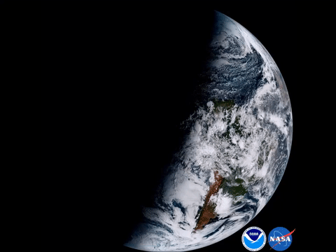
GOES-16 Earth & Moon

NOAA's GOES-16 satellite took this photo of Earth at 1:07 p.m. EDT (1807 GMT) on Jan. 15. It was created using several of the 16 spectral channels available on the GOES-16 ABI instrument.
GOES-16 Earth Animation
NOAA's GOES-16 satellite created the composite images that make up this animation in January 2017.
GOES-16 Caribbean

The Caribbean islands and part of the southeastern United States are visible in this photo taken by NOAA's GOES-16 weather satellite.
Hurricane Irma GOES East Sept. 9

The National Oceanic and Atmospheric Administration's GOES East satellite captured this visible image of Category 4 Hurricane Irma on Saturday (Sept. 9) at 10:37 a.m. EDT (1437 GMT).
GOES East View of Hurricane Harvey

This visible-light image of Hurricane Harvey taken from NOAA’s GOES East satellite on Aug. 25 at 10:07 a.m. EDT (1407 GMT) clearly shows the storm’s eye as the storm nears landfall on Texas’ southeast coast.
GOES East View of Hurricane Maria, Sept. 19, 2017

This image of Category 5 Hurricane Maria moving through the eastern Caribbean was taken at 11 a.m. EDT (1500 GMT) on Sept. 19, 2017, by NOAA's GOES East satellite.
