The usual number of eclipses in a year is four; in a few years there can be 5, 6, and even 7. The year 2024 is the usual 4-eclipse kind. What underlies this is that there are two "eclipse seasons" each year.
Each of them contains two (sometimes three) eclipses: one solar, one lunar, and sometimes another one of either type. The eclipse seasons are actually less than six months apart, by about 19-days, so they keep falling back that much earlier each year.
Last year they fell in April/May and October; this year they have shifted in the calendar to March/April and September/October. Next year they will have shifted back again, so that one will come in March, the second in September.
Related: Total solar eclipse 2024: Everything you need to know
What is an eclipse season?
It is a span of about a month during which eclipses are possible at the new and full moons, because the line of the crossing point of the moon's orbit with that of the Earth's (called a "node") is pointing near enough to the sun. The moon's orbit is tilted to the Earth's at an angle of just over 5 degrees; the nodes are the two points at which the planes intersect — that is, at which the moon passes down or up through the ecliptic plane. More often than not, the new moon will either pass too high or too low to cast its shadow on the Earth. But at least twice each year, the new moon will pass close enough to a node to cover the sun, resulting in an eclipse.
One number by which eclipses can be measured is what eclipse calculators call "gamma" (γ) or the axis-offset. It is the perpendicular distance from the Earth's center to the moon's axis, or in other words, a line drawn from the sun through the center of the moon and out along the axis of its shadow. If the offset were 0, the eclipse would be exactly central; if it is more than .9972 of an Earth-radius, the middle of one body's shadow misses the other; the greater the offset, the slighter the eclipse.
For our April 8 solar eclipse, the axis-offset amounts to .3431 of an Earth radius. Therefore, the moon throws its shadow not far north of the center of the Earth (the core or shadow axis passes 1,358 miles/2,185 km from the center).
In the other dimension, that of the distance from the Earth to the moon, the moon has to be nearer than average on April 8 if it is to completely cover the disk of the sun and indeed it is: the moon arrives at perigee — its closest point to the Earth, 222,979 miles (358,850 km) — about 25 hours before new moon; thus, the disk of the moon will appear 5.66 percent larger than the sun.
The mechanics
A month before the eclipse (on March 10) when it came around between the sun and Earth, the moon was flying too far to the south to cast its shadow upon the Earth's surface, because it had yet to reach its ascending node which was still about 40 hours ahead. But with the April new moon the ascending node is only about 6 hours ahead; so, the shadow strikes below the Earth's south side.
The March equinox — the first day of spring in the Northern Hemisphere — comes about 20 days prior to the start of the eclipse, so the Earth has begun to tilt north pole-forward (being most so at the June solstice).
For these reasons the shadow takes a general geographic course northward and also because the moon itself is ascending northward. And as a consequence, the track of the moon's umbral shadow path across the Earth might best be described as a "lazy S," which over the course of 3 hours and 15 minutes travels approximately 9,200 miles (14,800 km) and covers over 0.52% of Earth's surface area. Sweeping such a range of latitudes from 7 degrees south to 49 degrees north, causes it to visit a great diversity of climates, landscapes and human habitats.
The story of the shadow
The penumbra — the lighter/outermost part of the Earth's shadow — meets the Earth first at 15:42:11.8 Universal Time (U.T.) over the Pacific Ocean roughly 300 miles to the east-northeast of Tahiti, the largest island of the Windward group of the Society Islands in French Polynesia. This section of our globe is at the front of the moving and rotating Earth, now just turning into the view of the sun — in other words the sunrise line. So, the crew of a ship near this point would theoretically see the sun's topmost edge, just coming above the eastern horizon, ever-so-slightly obscured by the lowest edge of the moon.
Just over an hour later, the penumbra begins to spread over the Pacific coast of Mexico, where a small dent appears on the upper right portion of the sun as the silhouette of the moon slowly encroaches upon the sun's dazzling disk.
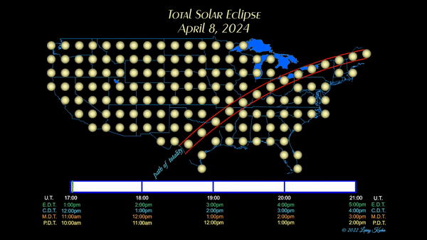
By 18:00 UT, the bulk of the penumbra — a circle measuring roughly 5,300 miles (8,500 km) in diameter — has spread rapidly northward onto the Earth so that all of Mexico and Central America, as well as southwest Canada and much of the contiguous United States (save for the mid-Atlantic and Northeast), sees varying degrees of a partial eclipse during the late morning and midday.

Then later, the remainder of the United States as well as Atlantic Canada see it during the afternoon, and finally, far to the east, parts of the United Kingdom get a very brief glimpse near local sundown.
Not quite an hour later, following the penumbra, the southern edge of a much darker shadow — the umbra, where the total eclipse is visible — arrives at 16:38:49.3 U.T., touching down on Earth farther to the west (because the Earth has been turning) and much farther to the north over the open waters of the Pacific, at a point about 1,900 miles (3,060 km) south-southwest of the big island of Hawaii.
This part of the umbra that makes its first contact with the Earth is some 89 miles (143 km) thick, so the axis (the midline of the shadow cone) arrives 1.1 minutes later, and the northern edge another 1.2 minutes later. But because it initially strikes the Earth's surface at a very oblique angle, in its opening moments the shape of the umbra resembles a very elongated ellipse, about 89 miles (143 km) at its widest but some 850 miles (1,370 km) long, while racing forward at some 8.4 miles (13.5 km) per second.
A container ship or fishing trawler that might fortuitously happen to be in this part of the Pacific Ocean during this time frame might witness (should skies be clear), the rapidly narrowing crescent of a barely risen sun being extinguished (or rekindled) by the dark disk of the passing new moon. Shortly after touching down on Earth, the umbra starts its turn toward the northeast.
Landfall!
At 11:05 a.m. M.S.T., the umbra will make its first landfall among Mexico's Islas Marias. Two minutes later, the shadow arrives at Mazatlán, a city in the Mexican state of Sinaloa. With a population of 490,000, it is the second-largest city in the state and is a very popular tourist destination, with its beaches lined with resort hotels, restaurants, bars and shops. The city will experience 4 minutes 18 seconds of totality with the sun standing 69 degrees above the southeast horizon.
About 200 miles (320 km) up track from Mazatlán, is the point of greatest eclipse — that spot along the eclipse track when the distance between the moon's shadow axis and Earth's geo-center reaches a minimum — which occurs at 12:17:17.9 p.m. C.S.T. Here, the central duration of totality is 4 minutes 28.1 seconds, and the sun's altitude is 69.8 degrees. The umbral shadow is now an oval of darkness, measuring 122 miles (196 km) wide and moving at 1,568 miles (2,525 km) per hour. The nearest population center is Nazas (pop. 3,600) which lies about 6 miles (10 km) to the south of the centerline of the path of totality.
The shadow enters the United States
At 1:27 p.m. C.D.T., the umbra crosses the Mexican border and enters the United States at Maverick County, Texas, beginning a 15-state tour taking 68 minutes. During this timeframe, the shadow will sweep rapidly northeast across Texas and Oklahoma, portions of the Deep South and Central Great Plains, the Greater Ohio Valley, northwest Pennsylvania, Upstate New York and northern New England.
In Texas, the umbra will visit four out of its top-five largest cities. At 1:34 p.m. C.D.T., San Antonio (pop. 1,452,000) will be virtually cut in half by the southern limit of the totality path, with the Far West Side, Alamo Farmsteads and North Central sections of the city tucked just inside of the totality path, and the duration of totality ranging from roughly 1.7 to 2.2 minutes. At San Antonio International Airport, the total phase will last about 50 seconds. Meanwhile, places farther to the south and east, such as Mission San Jose, Highland Hills and East Side will see either a single point of sunlight or perhaps a series of sunlight beads remaining in view as the peak of a 99.9 percent eclipse is reached.
The umbra will then pass through the state capital of Austin (pop. 965,000) where Austinites will enjoy a 1 minute 43 second totality beginning at 1:36:07 p.m. C.D.T.
Fort Worth (pop. 936,000) will be plunged into midday darkness for 2 minutes 39 seconds at 1:40:24 p.m. C.D.T. and 16 seconds later, totality will come to Dallas (pop. 1,304,000), where the total phase will last 3 minutes 48 seconds. Dallas makes up one-fifth of the much larger urbanized area known as the Dallas-Fort Worth metroplex, in which one quarter of all Texans live.
The lunar shadow then cuts across the southeastern corner of Oklahoma and at 1:51:34 p.m. C.D.T., totality will come to another state capital, Little Rock, Arkansas (pop. 205,000), lasting for 2 minutes 29 seconds. The city derived its name from a rock formation along the river, named the "Little Rock" by the French explorer Jean-Baptiste Bénard de la Harpe in 1722. The southeastern corner of Missouri also falls within the totality path with Cape Girardeau, the Show-Me State's largest city in the totality path getting 4 minutes 7 seconds of midday darkness beginning at 1:58:17 p.m. C.D.T.

Eclipse crossroads
The city of Carbondale, Illinois (pop. 22,000) billed itself as the "Eclipse Crossroads of America" in 2017 because it was near the centerline for the path of totality for that year's total eclipse (on Aug. 21), and in 2024, it again finds itself very close to the centerline of totality.
According to the law of averages, a specific geographic location will experience a total solar eclipse on the order of once every 375 years. But here is a most unusual case of a city being treated to a view of two total solar eclipses within a timeframe of less than 7 years! On April 8, totality returns to Carbondale, at 1:59:14 p.m. C.D.T. and lasts 4 minutes 8 seconds.
Through the Ohio Valley
The third state capital to experience the total eclipse is Indianapolis, Indiana (pop. 888,000). Colloquially known as Indy, the sun will be completely extinguished by the passing new moon for 3 minutes 49 seconds beginning at 3:06:02 p.m. E.D.T. It is the third-most populous city in the Midwest after Chicago and Columbus, Ohio, and the fourth-most populous state capital after Phoenix, Austin, and Columbus.
At 3:09:46.5 p.m. E.D.T., the southern edge of totality passes only about 13 miles (21 km) to the northwest of Cincinnati, Ohio (pop. 309,000), recently named among the 100 most livable cities in the world, at number 88, and is also on many Best Places to Live lists.
Those who are outside during maximum eclipse will no doubt will notice an eerie "counterfeit twilight" descend over the Queen City for several minutes, thanks to 99.4 percent of the sun's diameter being hidden by the moon. Three minutes later, at 3:12 p.m. E.D.T., a very similar story will be experienced by those living in Ohio's state capital and most populous city, Columbus (pop. 907,000), as the southern edge of the umbra also skirts by just to their northwest.
Before departing The Buckeye State, the umbra sweeps through Cleveland (pop. 373,000), the largest city on Lake Erie and one of the major cities of the Great Lakes region. Totality arrives here at 3:13:42 p.m. E.D.T. and lasts 3 minutes 49 seconds. Another Great Lakes city that will experience the total eclipse is Erie (pop. 93,000), situated in northwest Pennsylvania. They will receive a healthy 3 minutes 42 seconds of total eclipse commencing at 3:16:20 p.m. E.D.T.
New York and New England
From 3:16 p.m. to 3:27 p.m. E.D.T., the umbra passes through western and northern New York and will interact with three of its major cities. Buffalo (pop. 278,000) is the second most populated city in the state and with nearby Niagara Falls, make up the two-county Buffalo-Niagara Falls Metropolitan Statistical Area (MSA), which has an estimated population of 1.2 million. The city is almost directly on the center line of totality, providing a duration of 3 minutes 45 seconds of total eclipse commencing at 3:18:17 p.m. E.D.T.
The city of Rochester (pop. 211,000), a global center for science, technology, research and development, will enjoy 3 minutes 40 seconds of total eclipse beginning at 3:20:05 p.m. E.D.T.
Syracuse (pop. 149,000) is just inside the southern limit of totality, but will still see the total phase last for 1 minute 28 seconds starting at 3:22:59 p.m. E.D.T.
Then from 3:27 p.m. to 3:35 p.m. E.D.T., the shadow will pass through three New England states, Vermont, New Hampshire and Maine. Montpelier, Vermont (pop. 8,100) is the fourth state capital to be visited by the umbra, and will be witness to a 1 minute 41 second totality beginning at 3:27:33 p.m. E.D.T.
In New Hampshire, majestic Mount Washington unfortunately lies 18 miles outside the southern limit of the totality path and will see 99.1 percent of the sun's diameter covered at 3:29:52 E.D.T. However, Dixville Notch (pop. 4), known for being the first place to declare its results during United States presidential elections and the New Hampshire presidential primary, is inside of the shadow path. The lunar umbra will pass on through here for a 2 minute 46 second visit beginning at 3:28:34 p.m. E.D.T.
In Maine, the highest mountain in the state, Mount Katahdin at 5,269 feet (1,606 meters), will experience a 3 minute 22 second total eclipse beginning at 3:30:55 p.m. E.D.T. Maine is the least densely populated state east of the Mississippi River and the path of totality passes over many small towns and communities. Millinocket (pop. 4,100) bills itself as "Maine's Biggest Small Town" and where darkness falls during mid-afternoon beginning at 3:31:21 p.m. E.D.T., lasting for 2 minutes 57 seconds.
Canada ... then back out into space
The umbra will also visit the provinces of Ontario, Quebec and Atlantic Canada, bringing a 1 minute 52 second totality to Ontario's port city of Hamilton (pop. 569,000) at 3:18:10 p.m. E.D.T., but sadly, less than two minutes later at 3:19:53 p.m. E.D.T. it will pass just 6 miles (9 km) to the south of Canada's most populous city, Toronto (pop. 2,794,000). At maximum, the moon will cover all but one-tenth of a percent of the disk of the sun, likely — as will also be the case for Cincinnati and Columbus — causing a strange dusky twilight to descend over the city for a few minutes.
As was the case with San Antonio, another major metropolitan area that will be sliced in two by the shadow, is Canada's second-most populous city, Montreal (pop. 1,763,000). The southern and eastern sections of the Island of Montreal will be darkened by the umbra at around 3:26:53 p.m. E.D.T. with LaSalle getting 1.9 minutes of totality, Pierre Elliot Trudeau International Airport, 1.3 minutes and Longue-Pointe a mere 18 seconds. Meanwhile, places farther to the north and west, such as Mercier-Est, Montreal Nord and Pointe-Aux-Trembles lie barely outside of the zone of total eclipse.
Continuing rapidly east-northeast, the umbra will darken the province of New Brunswick. The capital city of Fredericton (pop. 63,100), will see 2 minutes 18 seconds of totality beginning at 4:33:45 A.D.T., while farther east, the shadow will briefly visit the north half of Prince Edward Island at 4:36 p.m. A.D.T. and a minute later the shadow sweeps over Quebec's Magdalen Islands. Then two minutes later, it provides a glancing blow to Victoria County on Cape Breton Island, Nova Scotia.
The umbra makes its final landfall on the Island of Newfoundland. After bringing 2 minutes 54 seconds of total eclipse for the 83 inhabitants of the tiny coastal hamlet of Maberly, the umbra will move out over the open waters of the Atlantic at 5:16:41.2 p.m. N.D.T. Its shape now resembles a broad ellipse and its ground speed has increased precipitously to 4,650 miles (7,480 km) per hour. The reason is that as it now rapidly nears the end of its track, this part of the Earth is sloping away from the shadow. At 19:55:34.2 U.T., the umbra slips off the Earth and back out into space at local sunset at a point roughly 500 miles (800 km) southwest of southern Ireland.
Now, all that is left is for the penumbra to slide off the Earth's surface. Last contact comes at 20:52:18.9 U.T. at a spot in the Atlantic Ocean some 1,500 miles (2,400 km) west of Lisbon, Portugal, at which point the eclipse of April 8th, 2024 passes into history.
Eclipse chronology
April 5
- 03:00:00 – Middle of Eclipse Season: The sun arrives at the same longitude as the moon's descending node.
April 7
- 17:32:00 – Moon at Perigee: Measured from the center of the Earth to the center of the moon, the distance is 222,979 miles (358,850 km).
April 8
- 12:18:00 – Moon's center reaches the ascending node of its orbit through the ecliptic.
- 15:42:11.8 – Partial Eclipse begins: First contact of moon's penumbral shadow cone with Earth at local sunrise.
- 16:38:49.3 – Total Eclipse begins: First contact of the moon's umbra (southern prolongation of its umbral cone) with the Earth at local sunrise.
- 16:39:58.5 – Central Eclipse begins: The umbra's center line first touches the Earth.
- 18:17:17.9 – Greatest Eclipse: The axis of the umbral shadow passes nearest (gamma = .3431 Earth radius) north of the center of the Earth. As seen from the point of greatest eclipse, the magnitude is 1.0566, that is, the moon covers the sun and .0566 of a sun-width more.
- 18:20:49.5 – New moon (Conjunction of moon with sun in ecliptic longitude): The moon's center is exactly north of the sun's as measured perpendicularly to the ecliptic.
- 18:36:00.0 – Conjunction of the moon and the sun in right ascension: The moon's center appears exactly north of the sun's as measured perpendicularly to the Earth's equator. The center of the eclipse takes place at local apparent noon, with the sun and moon on the meridian.
- 19:54:26.5 – Central Eclipse ends: The umbra’s center line leaves the Earth's surface.
- 19:55:34.2 – Total Eclipse ends: Last contact of the moon's umbra (southern prolongation of its umbral cone) with the Earth at local sunset.
- 20:52:18.2 – Partial Eclipse ends: Last contact of the moon's penumbral shadow cone with the Earth at local sunset.
Saros Lineage
This eclipse passes fairly near the center of the Earth (and is therefore fairly long) because it is approaching the middle of its saros series, or series of similar eclipses, at intervals of 18.03 years. This is saros series 139 and it began on May 17, 1501 with the first of 7 partial eclipses in the Arctic; it then moved south across the Earth, transitioning into no fewer than 12 of the uncommon hybrid or annular-total kind (annular at the beginning and end, but becoming total in the middle of their paths); then 43 purely total eclipses, of which this is the 11th, and the 30th eclipse overall in this series out of 71.
Those of a certain age will recall the 8th total eclipse of this series, that of March 7, 1970; a Saturday afternoon in which the umbra swept along/adjacent to the Atlantic Seaboard.
The most central member of saros 139 will be June 13, 2132, when the shadow axis passes just 73.6 miles (118.4 km) south of Earth's center. But the peak duration will continue to rise up to July 16th, 2186, which will be the longest total solar eclipse between 4000 BC and at least AD 6000 (10,000 years), lasting a maximum of 7 minutes, 29.22 seconds. Eclipse expert Jean Meeus calculates the maximum possible eclipse duration of totality in a solar eclipse is currently 7 minutes 32 seconds.
Beginning in 2619 the umbra will miss the Earth entirely, so that the series ends with 9 partials which nobody will travel to see, the last occurring on July 3, 2763 over the Southern Ocean and a small slice of Antarctica.
Joe Rao serves as an instructor and guest lecturer at New York's Hayden Planetarium. He writes about astronomy for Natural History magazine, the Farmers' Almanac and other publications.