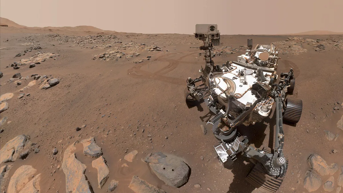
NASA's Perseverance rover has compiled a variety of photos since landing at its new home on Mars in February, offering a more comprehensive view of the Red Planet and its ancient past.
The six-wheeled robotic explorer, which landed on the surface of Mars on Feb. 18, 2021, is equipped with a total of 23 cameras — each of which captures a different perspective, from extreme close-ups to wide-angle, panoramic views.
"The imaging cameras are a huge piece of everything," Vivian Sun, the co-lead for Perseverance's first science campaign at NASA's Jet Propulsion Laboratory in Southern California, said in a statement. "We use a lot of them every single day for science. They're absolutely mission-critical."
In photos: NASA's Mars Perseverance rover mission to the Red Planet
The Perseverance rover touched down inside Mars' 28-mile-wide (45 kilometers) Jezero Crater, which is believed to have been a massive lake and delta system 3.5 billion years ago. One of the mission's primary science objectives is to search for evidence of ancient life on Mars.
The rover's SuperCam aids in the search for past life by firing a laser at mineral targets and analyzing the mineralogy and chemistry of the vaporized rock. The SuperCam includes the Remote Micro-Imager (RMI), which can zoom in on features the size of a softball from more than a mile away, according to the statement.
SuperCam is located on Perseverance's mast, or head, near a pair of other cameras called Mastcam-Z, which have a powerful zoom lens and are able to capture color images, 3D stereo images and high-definition video. The Mastcam-Z imagers — commonly referred to as the rover's "eyes" — help scientists identify target locations and which features to zoom in on.
These two instruments often work in tandem, with the Mastcam-Z providing a broader view and the SuperCam capturing a closer look.

A series of images taken on March 17, 2021, captures a detailed view of an escarpment called the "Delta Scarp," which is part of a fan-shaped river delta that formed in the crater.
In the image above, the bottom view, taken by the rover's Mastcam-Z, shows the base and plateau of the escarpment, while the top inset view is a mosaic of images taken by Perseverance's RMI from about 1.4 miles (2.25 km) away, according to the statement.
"This is showing huge boulders. That means there had to have been some huge flash flooding that occurred that washed boulders down the riverbed into this delta formation," Roger Wiens, principal investigator for SuperCam at Los Alamos National Laboratory in New Mexico, said in the statement.
"These large boulders are partway down the delta formation. If the lakebed was full, you would find these at the very top. So the lake wasn't full at the time the flash flood happened. Overall, it may be indicating an unstable climate. Perhaps we didn't always have this very placid, calm, habitable place that we might have liked for raising some microorganisms," Wiens said.
Images taken by Perseverance's cameras also suggest evidence of igneous rock that would have formed from lava or magma flowing on the crater floor before, during or after the lake formed, scientists said.
Next to each Mastcam-Z imager is a Navcam, which are designed to help the rover drive around Mars autonomously. At each stop, the rover uses its two navigation cameras to get a 360-degree view of the area. The image below shows a view from one of the Navcams, taken on July 1, 2021, after the rover traveled 358 feet (109 meters), which was its longest autonomous drive at the time.

"The navigation camera data is really useful to have those images to do a targeted science follow-up with higher-resolution instruments such as SuperCam and Mastcam-Z," Sun said in the statement.
The rover is also equipped with six hazard avoidance cameras, or Hazcams: four located on the front and two on the rear of the rover. The Hazcams help the rover avoid difficult terrain, such as large rocks, trenches or sand dunes. The front Hazcams also help guide the rover's robotic arm to take measurements, photos and collect rock and soil samples — which is another key goal of the mission.
Perseverance is designed to collect and cache dozens of samples, which will be brought to Earth as part of a later mission. The rover's robotic arm dons three cameras to assist in the selection of those samples: WATSON (Wide Angle Topographic Sensor for Operations and eNgineering), SHERLOC (Scanning Habitable Environments with Raman & Luminescence for Organics & Chemicals) — which includes an Autofocus and Contextual Imager (ACI), the rover's highest-resolution camera — and the PIXL (Planetary Instrument for X-ray Lithochemistry) Micro-Context Camera.
WATSON provides extreme close-up views, with the ability to hone in on the variety, size, shape and color of tiny grains in Martian rocks and sediment. The fine-scale camera is also able to discern the "cement" between grains, which provides new clues about Mars' ancient geological past, according to the statement.

The image above represents a rock target nicknamed "Foux." WATSON zoomed in on the area, capturing a roughly 1.4 by 1 inches (3.5 by 2.6 centimeters) view of the target on July 11, 2021. Close up views such as this help engineers position the rover's drill for extracting rock core samples, according to the statement.
"We're getting really cool spectra of materials formed in aqueous [watery] environments — for example sulfate and carbonate," Luther Beegle, SHERLOC's principal investigator at JPL, said in the statement. "Once we get over closer to the delta, where there should be really good preservation potential for signs of life, we've got a really good chance of seeing something if it's there."
Since Sept. 15, the rover had been investigating a thinly-layered outcrop called Bastide. The rover will take a brief break from sampling Martian rock, as it prepares for the Mars solar conjunction between Oct. 2 and Oct. 14.
Wrapped up a good week of science at “Bastide” rock. I’ve hit the road again and I’m on the lookout for a good “parking spot” to wait out solar conjunction (when the Sun blocks signals to Mars). Lots of “parking” spaces to choose from. Location map: https://t.co/uPsKFhW17J pic.twitter.com/OV9PgNB3F5September 23, 2021
"Wrapped up a good week of science at 'Bastide' rock. I've hit the road again and I'm on the lookout for a good 'parking spot' to wait out solar conjunction (when the Sun blocks signals to Mars). Lots of 'parking' spaces to choose from," according to a Tweet from NASA's Perseverance Mars Rover page.
Follow Samantha Mathewson @Sam_Ashley13. Follow us on Twitter @Spacedotcom and on Facebook.