New images of Mars explore the depths of the Red Planet's Valles Marineris canyon, the largest canyon system in the solar system.
The European Space Agency's (ESA) images, which were taken using the spacecraft's High Resolution Stereo Camera (HRSC), also capture incredible detail on the canyon floor. Unlike the Grand Canyon, which was carved by the Colorado River, Valles Marineris is believed to have formed from tectonic plates drifting apart. This violent movement at the Martian surface created a jagged canyon floor, as seen in the new images.
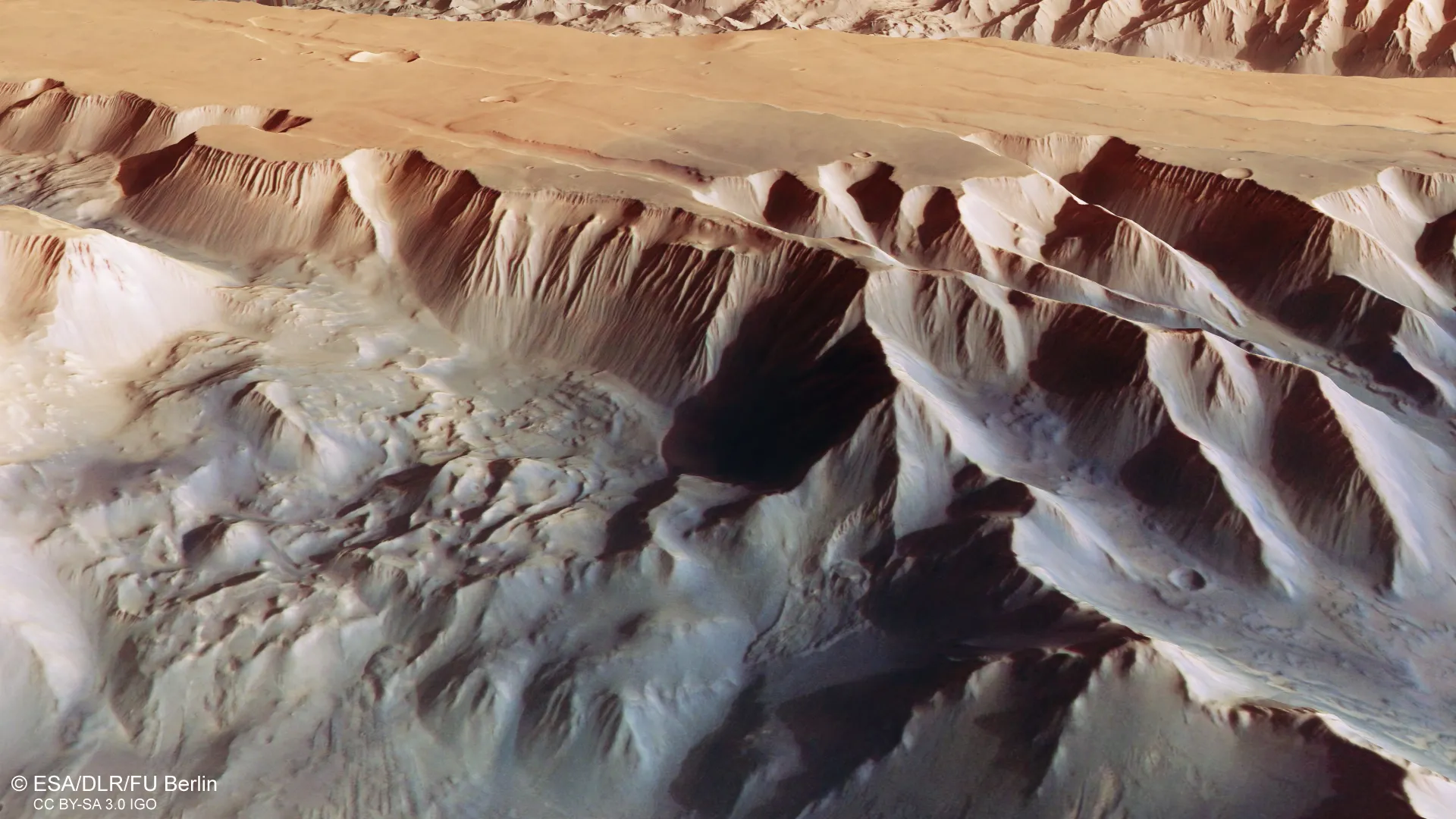
"The gnarly floor of Ius Chasma is equally fascinating," ESA officials wrote in the statement accompanying the new images. "As tectonic plates pulled apart, they appear to have caused jagged triangles of rock to form that look like a row of shark teeth. Over time, these rock formations have collapsed and eroded."
Related: Largest canyon in the solar system revealed in new images
ESA's Mars Express spacecraft, which has been orbiting the Red Planet since 2003, zoomed in on two trenches that form part of western Valles Marineris: Ius Chasma and Tithonium Chasma. The images not only capture incredible surface detail, but also highlight the impressive size of the trenches.
Valles Marineris stretches 2,500 miles (4,000 kilometers) long, 124 miles (200 km) wide, and 4.3 miles (7 km) deep — nearly ten times longer, 20 times wider and five times deeper than the Grand Canyon, according to ESA's statement.

The lus Chasma on the south side of the canyon is 522 miles (840 kilometers) long, while the Tithonium Chasma on the north side is 500 miles (805 km) long. For comparison, the Grand Canyon is 277 miles (446 km) long and just over a mile at its deepest point. On Earth, Valles Marineris would span the distance from the northern tip of Norway to the southern tip of Sicily, according to the statement.
ESA's view of the two chasms capture Mars' diverse surface features, ranging from dark sand dunes created by nearby volcanic activity, mountain-size mounds that've been eroded by wind, smaller bumps that may have formed from the evaporation of water that once filled the chasma, and evidence of a recent landslide caused by the collapse of the canyon wall.
Various spacecraft studying Valles Marineris have found evidence suggesting liquid water may have once filled the canyon. The Mars Express mission detected signs of water-bearing sulfate minerals in the area of Ius Chasma and Tithonium Chasma, while ESA's Trace Gas Orbiter (TGO), part of the ExoMars mission, detected water ice beneath the surface of Candor Chaos, located near the center of the massive canyon system.
Follow Samantha Mathewson on Twitter @Sam_Ashley13. Follow us on Twitter @Spacedotcom or on Facebook.
Join our Space Forums to keep talking space on the latest missions, night sky and more! And if you have a news tip, correction or comment, let us know at: community@space.com.