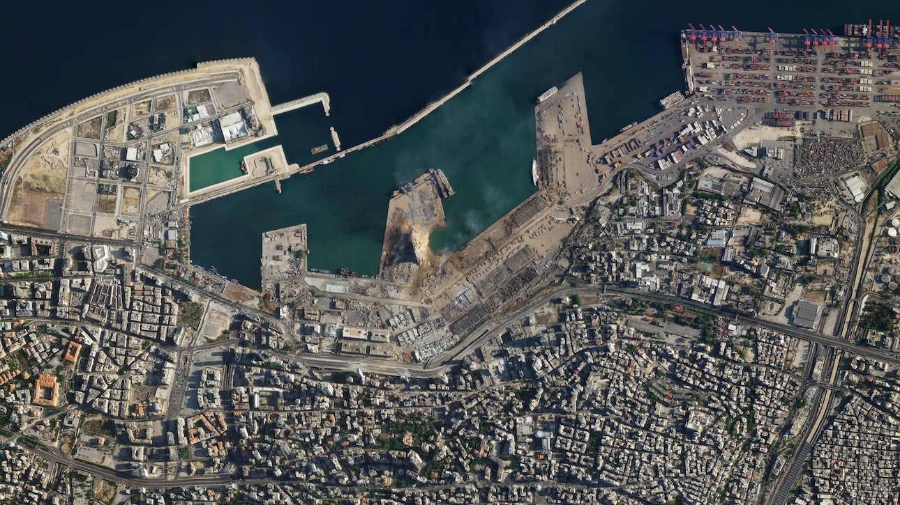
Beirut explosion devastation spotted from space (satellite photos)

Breaking space news, the latest updates on rocket launches, skywatching events and more!
You are now subscribed
Your newsletter sign-up was successful
Want to add more newsletters?

Delivered daily
Daily Newsletter
Breaking space news, the latest updates on rocket launches, skywatching events and more!

Once a month
Watch This Space
Sign up to our monthly entertainment newsletter to keep up with all our coverage of the latest sci-fi and space movies, tv shows, games and books.

Once a week
Night Sky This Week
Discover this week's must-see night sky events, moon phases, and stunning astrophotos. Sign up for our skywatching newsletter and explore the universe with us!

Twice a month
Strange New Words
Space.com's Sci-Fi Reader's Club. Read a sci-fi short story every month and join a virtual community of fellow science fiction fans!
The devastation wrought by the massive explosion in Beirut yesterday (Aug. 4) is viscerally apparent in satellite photos.
A SkySat spacecraft, operated by San Francisco-based company Planet, captured detailed imagery of the port of Beirut both before and after the blast, which killed at least 135 people and wounded about 5,000, according to The Guardian.
Planet posted the photos on Twitter today (Aug. 5). Colorado-based space technology company Maxar did the same, sharing pictures snapped by its satellites.
Related: Photos of Earth from space by Planet satellites
Before and after SkySat imagery shows the impact of yesterday’s explosion in Beirut. Imagery captured on May 31, 2020 and today, August 5, 2020. pic.twitter.com/8zCLDOZn4wAugust 5, 2020
The bird's-eye views show numerous buildings flattened by the explosion and a semicircular chunk gouged out of the port infrastructure, as if a monster rose out of the waves and took a giant bite.
The blast occurred after a fire reached a warehouse containing 2,750 tons of ammonium nitrate, an explosive compound often used as a fertilizer, Lebanese authorities have said. The ammonium nitrate had reportedly been stored in the warehouse since 2013, when it was offloaded from an impounded ship, the BBC reported.
Investigation into the tragic accident continues, as does the search for its victims.
Breaking space news, the latest updates on rocket launches, skywatching events and more!
Before and after images from the #explosion that happened in #Beirut, #Lebanon on August 4, 2020. Before image from June 2020 and after image from today, August 5, 2020. More imagery showing the devastation will follow. pic.twitter.com/dfj4ItyTXLAugust 5, 2020
These photos highlight how effectively private Earth-observation satellites can monitor the goings-on here on terra firma.
See the incredible damage from the #Beirut, #Lebanon explosion in these high-resolution #satellite images taken on August 5, 2020. Take a look at the large crater, the capsized Orient Queen and buildings with blown-out, shattered glass. pic.twitter.com/OxgzmZKNwRAugust 5, 2020
For example, Planet's fleet of orbital assets, which numbers in the hundreds, has also identified new earthquake-created ruptures in Earth's crust, spotted the aftermath of a failed Iranian rocket launch and imaged the damage left behind by an Iranian missile attack on Iraqi military installations, among other things.
And the many contributions of Maxar's WorldView satellites include helping humanity assess the impacts of the coronavirus pandemic on a global scale.
Mike Wall is the author of "Out There" (Grand Central Publishing, 2018; illustrated by Karl Tate), a book about the search for alien life. Follow him on Twitter @michaeldwall. Follow us on Twitter @Spacedotcom or Facebook.

Michael Wall is a Senior Space Writer with Space.com and joined the team in 2010. He primarily covers exoplanets, spaceflight and military space, but has been known to dabble in the space art beat. His book about the search for alien life, "Out There," was published on Nov. 13, 2018. Before becoming a science writer, Michael worked as a herpetologist and wildlife biologist. He has a Ph.D. in evolutionary biology from the University of Sydney, Australia, a bachelor's degree from the University of Arizona, and a graduate certificate in science writing from the University of California, Santa Cruz. To find out what his latest project is, you can follow Michael on Twitter.
