Satellite Images Help Focus Haiti Earthquake Relief

NASA and space agencies around the world are pointing theirsatellites toward Haiti to aid relief efforts and map damage caused by the devastatingearthquake earlier this week.
The 7.0magnitude quake struck the Caribbean island Tuesday, causing extensive destructionand fatalities estimated in the tens of thousands.
NASA?s Advanced Spaceborne Thermal Emission and ReflectionRadiometer (ASTER), a joint project with Japan, and its Earth Observing-1(EO-1) satellite are taking images of Haiti?s hardest-hit areas in multiplewavelengths of light.
Ground teams are comparing these pictures to pre-quakephotos to assess the damage, and to help rescue and relief workers know whereto focus their efforts, agency officials said.
A network of satellites working for the InternationalCharter on Space and Major Disasters has also joined the endeavor. The EuropeanSpace Agency, the French Space Agency (CNES), Japan, China, Canada and the U.S.have all pitched in under the charter.
Additionally, Germany, Italy and South Korea have alsodonated satellite time.
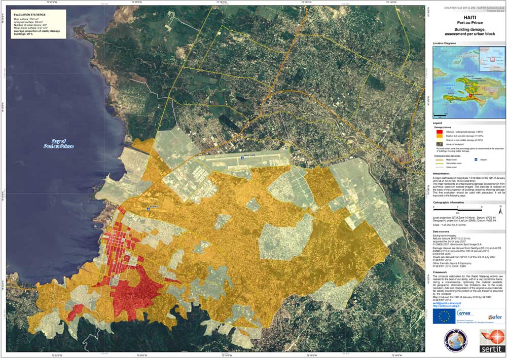
The resulting images show widespread ruin aroundPort-au-Prince, Haiti?s capital and largest city. The earthquake struckjust 10 miles (15 km) southwest of the city.
Breaking space news, the latest updates on rocket launches, skywatching events and more!
European researchers combined data from severalinternational satellites top build a so-called ?damage elevation map? that illustrateswhich regions of Haiti have seen the most damage. In the image, the mostobvious damage in Port-au-Prince can be seen in red.
?As soon as new data arrives, updated maps will be producedand made available to the international community,? ESA officials said.
- The Worst Natural Disasters Ever
- The Devastating Haiti Earthquake: Questions and Answers
- Images: Deadly Earthquakes

Clara Moskowitz is a science and space writer who joined the Space.com team in 2008 and served as Assistant Managing Editor from 2011 to 2013. Clara has a bachelor's degree in astronomy and physics from Wesleyan University, and a graduate certificate in science writing from the University of California, Santa Cruz. She covers everything from astronomy to human spaceflight and once aced a NASTAR suborbital spaceflight training program for space missions. Clara is currently Associate Editor of Scientific American. To see her latest project is, follow Clara on Twitter.
