Stunning Satellite Photo Reveals Volcanic Eruption Near Alaska

Breaking space news, the latest updates on rocket launches, skywatching events and more!
You are now subscribed
Your newsletter sign-up was successful
Want to add more newsletters?

Delivered daily
Daily Newsletter
Breaking space news, the latest updates on rocket launches, skywatching events and more!

Once a month
Watch This Space
Sign up to our monthly entertainment newsletter to keep up with all our coverage of the latest sci-fi and space movies, tv shows, games and books.

Once a week
Night Sky This Week
Discover this week's must-see night sky events, moon phases, and stunning astrophotos. Sign up for our skywatching newsletter and explore the universe with us!

Twice a month
Strange New Words
Space.com's Sci-Fi Reader's Club. Read a sci-fi short story every month and join a virtual community of fellow science fiction fans!
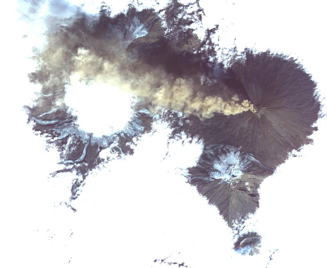
Eruptions from one of the most active volcanic regions in the world sent plumes of ash and steam into the sky this week, as captured in a spectacular image by an Earth-monitoring satellite.
Klyuchevskoy, a massive stratovolcano made up of ash and hardened lava, is located in the Russian Kamchatka Peninsula, near the Pacific Ocean. The volcano rises 10,771 feet (3,282 meters) above sea level, according to NASA, and behaves similarly to the volcanoes located in the nearby islands of Alaska. The Aleutian Islands, which sit in the Bering Sea and extend toward this Russian peninsula, are part of Alaska. According to the Smithsonian Institution's Global Volcanism Program, the 49th state has produced 70 percent of all historical eruptions in the United States, and a "vast majority" of those have occurred in this region in particular.
In the image, Klyuchevskoy is seen releasing a stream of ash that moves west, and the slightly smaller Bezymianny volcano is also seen jettisoning an eruption — of steam rather than ash — to the south, NASA officials said in a statement. The ASTER satellite captured the phenomena on Aug. 20, and the image covers an area of 12 miles by 14 miles (19.5 by 22.7 kilometers). [Astronaut in Space Sees Mount Etna Volcano Eruption (Photo)]
ASTER, which stands for Advanced Spaceborne Thermal Emission and Reflection Radiometer, is a dual-nation project: it is operated by NASA's Jet Propulsion Laboratory and Japan Space Systems. ASTER observes changes to Earth's surface and provides scientists from various disciplines with useful data, NASA officials said in the statement. The satellite monitors glacial movement, potentially active volcanoes, the physical properties of clouds, the degradation of coral reefs, the surface temperature of soils and crop stress, and thermal pollution.
The volcanoes themselves have also helped scientists to understand ancient vegetation. Millions of years ago, volcanic ash settled on sequoia and metasequoia trees after a volcanic eruption, which created the petrified forests that paleontologists can study today in places such as Unga Island in Alaska.
Editor's Note: NASA officials have clarified that the pictured volcano is in facet Klyuchevskoy, not Shiveluch as in the release; the article has been corrected to reflect that change.
Follow Doris Elin Salazar on Twitter @salazar_elin. Follow us @Spacedotcom, Facebook and Google+. Original article on Space.com.
Breaking space news, the latest updates on rocket launches, skywatching events and more!

Doris is a science journalist and Space.com contributor. She received a B.A. in Sociology and Communications at Fordham University in New York City. Her first work was published in collaboration with London Mining Network, where her love of science writing was born. Her passion for astronomy started as a kid when she helped her sister build a model solar system in the Bronx. She got her first shot at astronomy writing as a Space.com editorial intern and continues to write about all things cosmic for the website. Doris has also written about microscopic plant life for Scientific American’s website and about whale calls for their print magazine. She has also written about ancient humans for Inverse, with stories ranging from how to recreate Pompeii’s cuisine to how to map the Polynesian expansion through genomics. She currently shares her home with two rabbits. Follow her on twitter at @salazar_elin.
