


Since August 2012, NASA's Curiosity rover has been carving a path across the Martian surface, trying to understand more about the environment of the Red Planet. Where did water flow? Was it habitable? And what other geologic history took place in Gale Crater and Mount Sharp? Now that Curiosity is on the lower reaches of Mount Sharp, it has taken several spectacular images of dunes, rocks and even a meteorite. Here are some of its neatest images from the past year.
Dunes-day

Get out your 3-D glasses and admire this 13-foot-tall dune on Mars! Called Namib Dune, it was part of a study Curiosity did on active sand dunes (meaning that the dunes migrate rapidly every year). Namib is part of the Bagnold Dunes region, which migrate up to one meter annually.
"As on Earth, the downwind side of a sand dune has a steep slope called a slip face," NASA said in a statement. "Sand grains blowing across the windward side of a dune become sheltered from the wind by the dune itself. The sand falls out of the air and builds up on the lee slope until it becomes steepened and flows in mini-avalanches down the face."
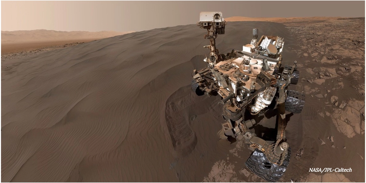
Sandy selfie

This is another view of the Bagnold Dune field with the Curiosity rover in front. While this "selfie" does look cool, it's also useful to NASA engineers who can monitor the rover's condition. One of the early concerns of the Curiosity mission, for example, was how quickly the wheels were wearing down. NASA began driving on smoother ground and has decelerated the rate of wear.
RELATED: Get Immersed in Curiosity's 360 Degree Mars Dune
The image was taken on Jan. 19, 2016, Curiosity's 1,228th Martian day of work. You don't see the arm that took the selfie because it was positioned out of the shots during the capture of the pictures taken for this mosaic.
Hey, knobby, knobby

Martian rock is an interesting thing to examine because it tells us so much about the geological history of Mars. Here, you can see some knobs on a sandstone inside of the Murray geological unit. For some reason, these knobs appear to be better able to stop erosion than the host rock underneath.
"The site is at a zone on lower Mount Sharp where mudstone of the Murray geological unit — visible in the lower right corner here — is exposed adjacent to the overlying Stimson unit," NASA said in a statement. "The exact contact between Murray and Stimson here is covered with windblown sand. Most other portions of the Stimson unit investigated by Curiosity have not shown erosion-resistant nodules."
Rock bar

This gorgeous panorama (including the shadow of Curiosity at right) shows off a vista nicknamed "Naukluft Plateau", on the lower part of Mount Sharp. Curiosity snapped this series of images on April 4, 2016 so that geologists could get a sense of context of the region. It helps them better place the history of the rocks that Curiosity looks at close up, and to make comparisons to processes on Earth.
RELATED: Mapping Mars' Ripples Unveils Dune Mysteries
"Since landing, the rover traversed through terrains dominated by water-lain sedimentary rocks (mudstones and siltstones, and early on, conglomerates), some of which have contained minerals like clays that attest to the ancient presence of water," NASA said in a statement. "However, the rover crossed into very different geology while climbing onto the Naukluft Plateau. The sandstone here appears to be dominated by thick layers of windblown sand, suggesting that these deposits formed in a drier epoch."
Ripples and dust

Even the ripples on Mars are from another planet. The larger ripples that you see in this picture, which are about 10 feet apart, have not been seen on Earth. They also were not seen before Curiosity on Mars. The smaller ripples, however, are similar to what we have on Earth. While this image was taken in December 2015 at the Bagnold dune field, NASA released it in June 2016. Raw pictures are sent down to Earth immediately for the public to download, but the agency sometimes takes months to post-process the imagery for a more detailed view.
"The component images were taken in early morning at this site, with the camera looking in the direction of the sun," NASA said in a statement. "This mosaic combining the images has been processed to brighten it and make the ripples more visible. The sand is very dark, both from the morning shadows and from the intrinsic darkness of the minerals that dominate its composition."
Autonomous pew-pew

While self-pointing laser-firing robots sound a little scary on Earth, the idea has peaceful applications on Mars. Curiosity can select some targets for laser analysis using its on board software. Specifically, if the rover has just driven to a site, it lets the rover get started on the composition science while scientists are still getting their bearings. Here, you can see how it chose the target highlighted with a yellow dot, and the analysis performed at right.
RELATED: The Mysteries Behind the Dunes of Mars
"Curiosity's ChemCam zapped a grid of nine points on a rock chosen for meeting criteria set by the science team," NASA said in a statement. "In this run, parameters were set to find bright-toned outcrop rock rather than darker rocks, which in this area tend to be loose on the surface. Within less than 30 minutes after the Navcam image was taken, ChemCam had used its laser on all nine points and had taken before-and-after images of the target area."
Craggy beauty

What looks like a random assortment of rocks at Murray Buttes actually tells a bit about the long history of ancient Mars. Today the planet is dominated by wind-blown erosion, and this image shows us that these processes were also important in the distant past. Separately, Curiosity has also found evidence of watery erosion before reaching the higher areas of Mount Sharp.
"The buttes and mesas rising above the surface in this area are eroded remnants of ancient sandstone that originated when winds deposited sand after lower Mount Sharp had formed," NASA said in a statement. "The layering within the sandstone is called 'cross-bedding' and indicates that the sandstone was deposited by wind as migrating sand dunes."
Future vision

This is an image taken in late 2016 showing the rover's view, including spots where it plans to climb further on in the mission. The orangey rocks are the bottom of Mount Sharp. Above that is a ridge-forming layer known as the Hematite Unit (after the substance that forms in water.) Above that is the Clay Unit (hard to see in this picture). The rounded hills are the Sulfate Unit, where Curiosity will go next. Further out are high slopes of Mount Sharp, which Curiosity will be able to see, but not touch.
RELATED: Space Invader on Mars: Curiosity Finds a Meteorite
"Variations in color of the rocks hint at the diversity of their composition on lower Mount Sharp," NASA said in a statement. "The purple tone of the foreground rocks has been seen in other rocks where Curiosity's Chemical and Mineralogy (CheMin) instrument has detected hematite. Winds and windblown sand in this part of Curiosity's traverse and in this season tend to keep rocks relatively free of dust, which otherwise can cloak rocks' color."
Alien visitor

We can't get over how cool this is: human-made rover voyages to an alien planet, moves around a little bit and bumps into a rock that happens to be alien to the alien planet's environment. You're looking here at an iron-nickel meteorite that is about the size of a golf ball. It's nicknamed "Egg Rock" after a site in Maine. "Iron-nickel meteorites are a common class of space rocks found on Earth, and previous examples have been found on Mars, but Egg Rock is the first on Mars to be examined with a laser-firing spectrometer," NASA said in a statement.
Path through history

You can see here Curiosity's path on Mars through November 2016. At left are images of the drilled holes where the rover got 15 rock-powder samples. Also pictured are spots where the Mars rover collected its first 19 rock or soil sample to be analyzed inside of the vehicle.
It's all a path to help us better understand the history of Mars, and whether the area can be of use to humans in the future. NASA is hoping to send humans to the Red Planet in the 2030s, and plans to send several more orbiters and rovers to the planet in the intervening years to scout the area out. A long-term goal also is a sample-return mission to bring material from Mars to Earth.
