
China Launches High-Resolution Commercial Imaging Satellite
PARIS — China’s first domestically built commercial high-resolution optical Earth observation satellite was launched Oct. 7 in the latest example of China’s lightning-fast transformation from satellite imagery importer to producer.
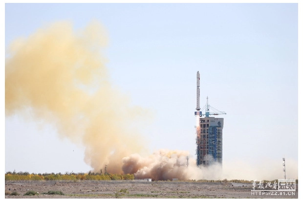
Operating from the Jiuquan Satellite Launch Center in northern China’s Gansu Province, a Chinese Long March 2D rocket placed the four-satellite Jilin-1 payload into a 655-kilometer polar low Earth orbit, the Chinese Academy of Sciences said.
The satellite was built by Chang Guang Satellite Technology Co., which is located in Jilin Province and is a commercial spinoff of the Chinese Academy of Sciences’ Changchun Institute of Optics, Fine Mechanics and Physics.
How much commercial business can be generated from the satellite on its own is unclear. But Chang Guang does not lack for ambition. It plans to have 16 satellites in orbit by the end of 2016 in what it calls the second stage of its program, with 60 satellites operational by 2020 — enough to offer a 30-minute revisit capability anywhere in the world.
The company has said it wants 138 satellites in service by 2030, providing 10-minute revisits, in the program’s fourth and final stage.
The launch was the 10th of China’s Long March rocket family in 2015 and the sixth since Sept. 12. China Great Wall Industry Corp. (CGWIC) of Beijing, which markets the rocket overseas, said it expects to maintain a launch rhythm of 15-20 Long March campaigns per year in the coming years regardless of whether the U.S. government lifts its ban on the export of U.S. satellite parts to China.
CGWIC Vice President and General Manager Zhiheng Fu said the forecast Chinese government demand will account for nearly all of the near-term launches, many of them scheduled to place China’s Beidou satellite positioning, navigation and timing constellation into medium Earth orbit.

China has been a large market for satellite Earth observation, mainly from U.S. and European vendors, for more than 20 years. But since 2009 China has rapidly been replacing imports with imagery from its own satellites — first in low and medium resolution for wide-scale mapping, and more recently for sharper-resolution imagery as well.
The China Center for Resources Satellite Data and Application (CRESDA), in a Sept. 17 presentation to the World Satellite Business Week conference here, said Chinese demand for non-Chinese satellite imagery at resolutions of 2.5 meters or less has fallen from more than 8 million square kilometers in 2009 to near zero in 2013.
During that period, Chinese domestic satellites’ share of the medium-resolution market went from 5 percent to 100 percent.
What was true in medium resolution is now happening in high resolution.
Zikuan Zhou, CRESDA’s director of international business development, said the cost of imagery with 1-meter resolution or sharper, much of it still provided by non-Chinese sources, has dropped sharply — from 40 Chinese yuan ($6.40) per square kilometer in 2009 to 16 yuan now.
Image processing fees have followed suit, dropping by about 30 percent between 2010 and 2015, according to CRESDA. Zhou said the sharpest-resolution satellite in China’s domestic fleet — before Jilin-1 — was the 80-centimeter-resolution GF-2, launched in 2014.
These trends have occurred at a time when the overall market for Earth observation imagery in China has continued to expand quickly.
The Jilin-1 launch, if followed by a constellation next year, will present a competitive challenge to Twenty First Century Aerospace Technology Co. Ltd. (21AT) of Beijing, whose three-satellite Beijing-2 constellation was launched in July and is scheduled to begin service by the end of October.
The Beijing-2 satellites, with a 1-meter ground resolution, were built by Surrey Satellite Technology Ltd. (SSTL) of Britain, and remain SSTL property. But 21AT has purchased the full capacity of all three satellites.
Officials from 21AT have said that despite the fact that their satellites were built outside China, Chinese government authorities have indicated that 21AT’s imagery products will have the same access to the Chinese government market as Chinese-built systems.
This story was provided by SpaceNews, dedicated to covering all aspects of the space industry.