New maps of the topography of Mars provide evidence of the existence of an ocean on the planet in its ancient history, with implications for its ability to have once supported life.
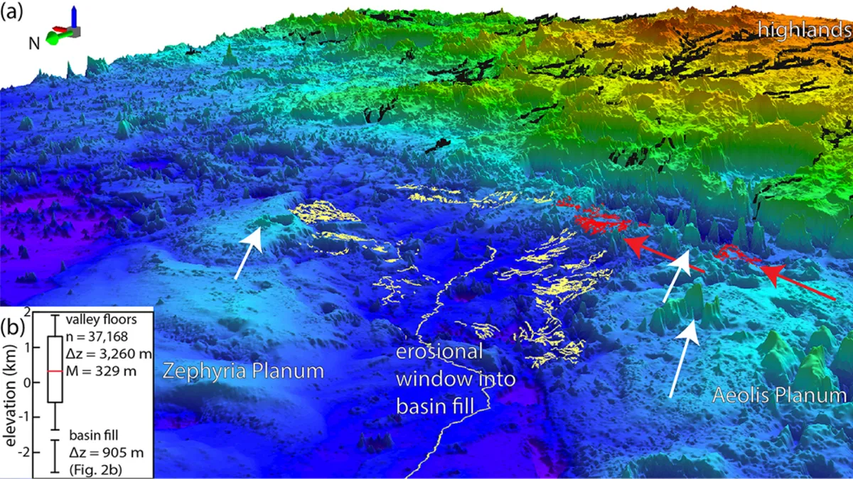
A map of the Martian region known as Aeolis Dorsa — a boundary that separates the elevated, cratered southern highlands of Mars from the planet's smooth northern lowlands — strongly suggests a shoreline left by a massive ocean.
The map of the area reveals that the Red Planet once experienced sea-level rise consistent with a warm wet climate in stark contrast with the frozen and dry Martian landscape seen today.
"What immediately comes to mind as one the most significant points here is that the existence of an ocean of this size means a higher potential for life," Benjamin Cardenas, an assistant professor of geosciences at Penn State University and leader of the research, said in a statement. "It also tells us about the ancient climate and its evolution. Based on these findings, we know there had to have been a period when it was warm enough and the atmosphere was thick enough to support this much liquid water at one time."
Related: Ancient Mars microbes triggered climate change that made it hard for them to survive
While planetary scientists are sure that Mars was once a much more watery planet than it is today, a debate has raged with regard to whether an ocean existed in the planet's northern hemisphere.
Cardenas and his colleagues were able to answer this question by using topological data to show evidence of a roughly 3.5-billion-year-old shoreline. One aspect of this geological feature was the substantial accumulation of sediments covering hundreds of thousands of square miles and with a thickness of around 3,000 feet (900 meters).
"The big, novel thing that we did in this paper was to think about Mars in terms of its stratigraphy and its sedimentary record," Cardenas said. "On Earth, we chart the history of waterways by looking at sediment that is deposited over time. We call that stratigraphy, the idea that water transports sediment and you can measure the changes on Earth by understanding the way that sediment piles up. That's what we've done here — but it's Mars."
The scientists used United States Geological Survey-developed software to assess map data of Mars collected by the Mars Orbiter Laser Altimeter (MOLA) aboard NASA's Mars Global Surveyor (MGS) spacecraft, which orbited the planet between 1996 and 2006.
The data revealed over 4,000 miles (6,500 kilometers) of fluvial ridges, which are relics of past water channels filled with sediments that become more elevated than the surrounding landscape. The team grouped these fluvial ridges into 20 systems demonstrating that they likely formed from eroded river deltas or submarine channel belts which constitute the remnants of an ancient shoreline on Mars.
The researchers concluded that Cardenas Aeolis Dorsa must once have been covered with an ocean, the remnants of which can today be seen in the densest concentration of fluvial ridges anywhere on the Red Planet.
"The rocks in Aeolis Dorsa capture some fascinating information about what the ocean was like," Cardenas explained. "It was dynamic. The sea level rose significantly. Rocks were being deposited along its basins at a fast rate. There was a lot of change happening here."
The team was able to understand the evolution of the region's paleogeography by observing elements of rock formation like ridge-system thicknesses, elevations, locations, and possible sedimentary flow directions.
Because ancient sedimentary basins on Earth contain information about our planet's evolving climate and the emergence and development of life, Cardenas thinks that if scientists want a similar understanding of the same things on Mars, Aeolis Dorsa is an excellent place to start.
"A major goal for the Mars Curiosity rover mission is to look for signs of life. It's always been looking for water, for traces of habitable life. This is the biggest one yet," Cardenas said. "It's a giant body of water, fed by sediments coming from the highlands, presumably carrying nutrients. If there were tides on ancient Mars, they would have been here, gently bringing in and out water.
"This is exactly the type of place where ancient Martian life could have evolved."
The research was published in the Journal of Geophysical Research: Planets on Oct. 12.
Follow us on Twitter @Spacedotcom or on Facebook.