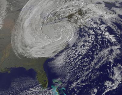
Frankenstorm Sandy Spotted Dying Out on Halloween

Breaking space news, the latest updates on rocket launches, skywatching events and more!
You are now subscribed
Your newsletter sign-up was successful
Want to add more newsletters?
After wreaking havoc on the East Coast, Hurricane Sandy was spotted by a NASA satellite as it weakened into a remnant low pressure system over Pennsylvania on Halloween.
Sandy was a Category 1 hurricane as it approached the coast of New Jersey on Oct. 29, packing winds of up to 90 mph (145 kph) that spread over a vast distance. Its hurricane-force winds extended 175 miles (280 kilometers) from its center, and tropical storm-force winds extended 520 miles (835 km).
The hurricane then became a post-tropical cyclone and merged with a cold front to become a hybrid nor'easter. The storm brought record storm surge to New York City, caused extraordinary damage along the New Jersey coastline and even dumped feet of snow on some places further inland, such as West Virginia.
Article continues belowAt 5 p.m. on Halloween night, the Hydrometeorological Prediction Center (which took over forecasting after Sandy was deemed to no longer be a tropical system), said that the storm no longer had a "discernible surface circulation," meaning it had weakened into a low pressure trough (or extended area of low pressure) over Pennsylvania, according to a NASA release.
The GOES-13 satellite caught a picture of the system earlier on Halloween, at 8:40 a.m. EDT.
The storm's influence isn't over yet, though. The HPC's last advisory on the system, made at 11 a.m. EDT yesterday (Oct. 31), noted that though the wind, snow and rains from Sandy are continuing to diminish, there are still gale-force wind warnings in place for parts of the Great Lakes, as well as flood watches in warnings there and in New England and the northern Mid-Atlantic states.
Winter storm warnings and advisories are also still in place for the central Appalachians, where some places have seen more than 2 feet (0.6 meters) of snow.
Breaking space news, the latest updates on rocket launches, skywatching events and more!
This story was provided by OurAmazingPlanet, a sister site to SPACE.com. Follow OurAmazingPlanet for the latest in Earth science and exploration news on Twitter @OAPlanet. We're also on Facebook & Google+.

Andrea Thompson is an associate editor at Scientific American, where she covers sustainability, energy and the environment. Prior to that, she was a senior writer covering climate science at Climate Central and a reporter and editor at Live Science, where she primarily covered Earth science and the environment. She holds a graduate degree in science health and environmental reporting from New York University, as well as a bachelor of science and and masters of science in atmospheric chemistry from the Georgia Institute of Technology.

