Watney Would Approve: Ordnance Survey Maps Mars

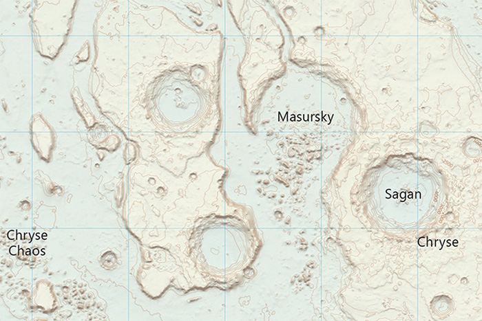
The British mapping agency Ordnance Survey has created a map of the Martian surface using precision NASA data — and it's beautiful.
PHOTOS: Tour 'The Martian' Movie Set… On Mars
As an avid hiker when I was a schoolkid, Ordnance Survey maps (yes, paper maps, no iPhone in sight) were an essential part of exploring the great British outdoors. Whether I was lost in the bogs of Dartmoor or trying to find the best route through the craggy Snowdonia terrain, an OS map was there, usually mud splattered and folded haphazardly in my pocket with a trusty plastic compass (yes, a real compass, with a magnetized arrow, no GPS in sight). I have fond memories that, no matter how lost I was all that was required was some practiced map work, combined with the stunning precision of an OS map, and my fellow mountaineers and I would find our way home safely.
So when I found out that the OS had commissioned their own map of the Martian surface, I was thrilled. And after seeing the full-resolution versions uploaded to the OS Flickr account, they didn't disappoint.
PHOTOS: Mapping Mars' Ripples Unveils Dune Mysteries
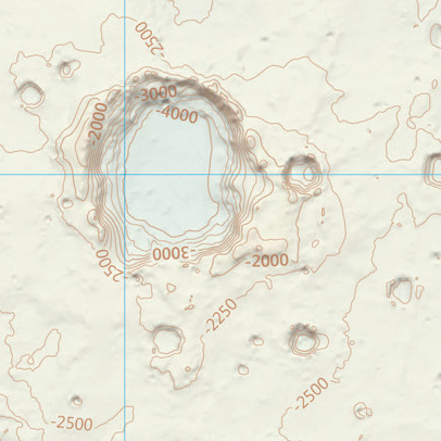
The key thing with OS maps are the wonderfully detailed contours that pinpoint terrain height with a lovely soft palette that is both easy on the eye and filled with critical information. So, in keeping with the traditional OS style, precision NASA terrain data was used to plot landscape elevation, a style that has a more traditional vibe than many modern extraterrestrial maps.

"The cartographic style is something that is very different to your typical planetary map and is identifiable as an OS map," said OS Cartographic Designer Chris Wesson in a blog. Wesson took 2 months to design the final product.
Breaking space news, the latest updates on rocket launches, skywatching events and more!
"The key ingredients to this style are the soft colour palette, the traditional map features such as contours (in brown-orange) and grid lines (in cyan), and the map sheet layout complete with legend," he said. "We even have a far more traditional representation of map components such as title, scale bar and graticules when compared with equivalent maps by space agencies and so on. Various cartographic techniques such as multiple lighting angles and exaggerations have also been used to enhance the shading of the relief, as well as to produce a generalized set of contour lines and optimize map label placement."
PHOTOS: The Psychedelic Landscape of Mars
Included in the map are the locations of Mars missions and labels of named Mars craters and other geological features.
Of course, looking at the beautiful Mars terrain plotted on an OS map makes me think how nice it would be to take a paper version on a hike across Meridiani Planum to navigate to NASA's Mars rover Opportunity, or use the map to navigate my way through the depths of Valles Marineris. But Wesson is realistic about the use of paper in the Martian environment, considering the need for a spacesuit.
"It is a nice thought, that one day people could pinpoint the landscape around them from a map just as in the British countryside but the map may be quite different by then," he said. "I have to take my ski gloves off to unfold a piste map! So I imagine even if the content was useful some design thought into the product format would be required. Do astronauts have heads up displays on their visors?"
NEWS: NASA Ponders Where to Land Astronauts on Mars
Alas, it's not only the practicality of a paper map that causes a problem — if I wanted to relive my childhood hiking adventures on Mars with a map and compass, the compass probably wouldn't be of much use. Compasses need a global magnetic field to point to magnetic north; Mars doesn't have a global magnetic field. So I'd probably need the help of a Mars GPS system after all. Bummer.
Still, the OS map certainly shows how we can view the alien terrain in a more familiar, terrestrial light — especially if it can be adapted for future Martian use. Mark Watney would approve.
Sources: Flickr, Ordnance Survey
Originally published on Discovery News.
Join our Space Forums to keep talking space on the latest missions, night sky and more! And if you have a news tip, correction or comment, let us know at: community@space.com.
Ian O'Neill is a media relations specialist at NASA's Jet Propulsion Laboratory (JPL) in Southern California. Prior to joining JPL, he served as editor for the Astronomical Society of the Pacific‘s Mercury magazine and Mercury Online and contributed articles to a number of other publications, including Space.com, Space.com, Live Science, HISTORY.com, Scientific American. Ian holds a Ph.D in solar physics and a master's degree in planetary and space physics.
