


Photographer captures rare 'gigantic jets' of upside-down lightning blasting out of Atlantic hurricane
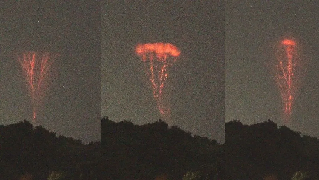
On Aug. 20, Puerto Rico-based photographer Frankie Lucena was taking pictures of a passing storm system that would soon evolve into the ongoing Hurricane Franklin, when a rare phenomenon of nature flashed before his eyes: Several enormous bolts of lightning, blasting straight upward out of a storm cloud and stopping just below the edge of space.
Upward-moving lightning bolts like these are known as gigantic jets. They are the rarest and most powerful type of lightning, occurring as few as 1,000 times a year and packing more than 50 times the power of a typical lightning bolt. The upside-down bolts can climb more than 50 miles (80 kilometers) above Earth's surface, touching the bottom of the ionosphere, the vast layer of electrically charged particles where the top of Earth's atmosphere meets the bottom of outer space. (Space technically begins at 62 miles, or 100 km, above sea level, while the ionosphere stretches from roughly 50 to 400 miles, or 80 to 640 km, above sea level.)
While rare, gigantic jets are not an unfamiliar sight during Atlantic hurricane season, gigantic jets are reported most frequently in tropical regions, especially during rapidly intensifying tropical storms like Franklin, according to an August 2022 study in the journal Science Advances.
Related: NASA flew a modified U-2 spy plane into thunderstorms to study super-energetic gamma-rays
Still, scientists have known about the phenomenon for only about 20 years, and much about it remains a mystery, including why the bolts shoot upward into the sky rather than slashing down to the ground. The gargantuan upward-flying bolts may be the result of some kind of blockage that prevents lightning from escaping through the bottom of the cloud, the authors of the 2022 study wrote, but the exact mechanism is still unknown.
There may be more chances to observe and study the bolts this year, as Atlantic hurricane season has just begun in full force. Franklin has since moved north toward Bermuda, intensifying into the first major hurricane of the 2023 season, according to the National Weather Service. While experts warn of potentially life-threatening rip currents along the East Coast of the United States, Hurricane Franklin is not currently forecast to make landfall.
On Aug. 30, Hurricane Idalia made landfall in Florida as a Category 2 storm, resulting in at least two confirmed deaths. The storm is being fueled by off-the-charts ocean temperatures, which have broken every record since satellite measurements began in the 1980s. The record-high temperatures have resulted from a combination of human-caused climate change and an El Niño event, which is forecast to substantially exceed the last strong event in early 2016.
