New York City is sinking — and it's not just because of the flooding
In some places, it's actually rising.

While the ground may feel stable under your feet, it's always moving ever so slightly — not just horizontally with the movement of tectonic plates, but also vertically. And New York City, in particular, is sinking. (No, it's not because of all the recent flooding that has seen commuters swimming on the streets of the West Village and cars stuck indefinitely on the Franklin D. Roosevelt highway).
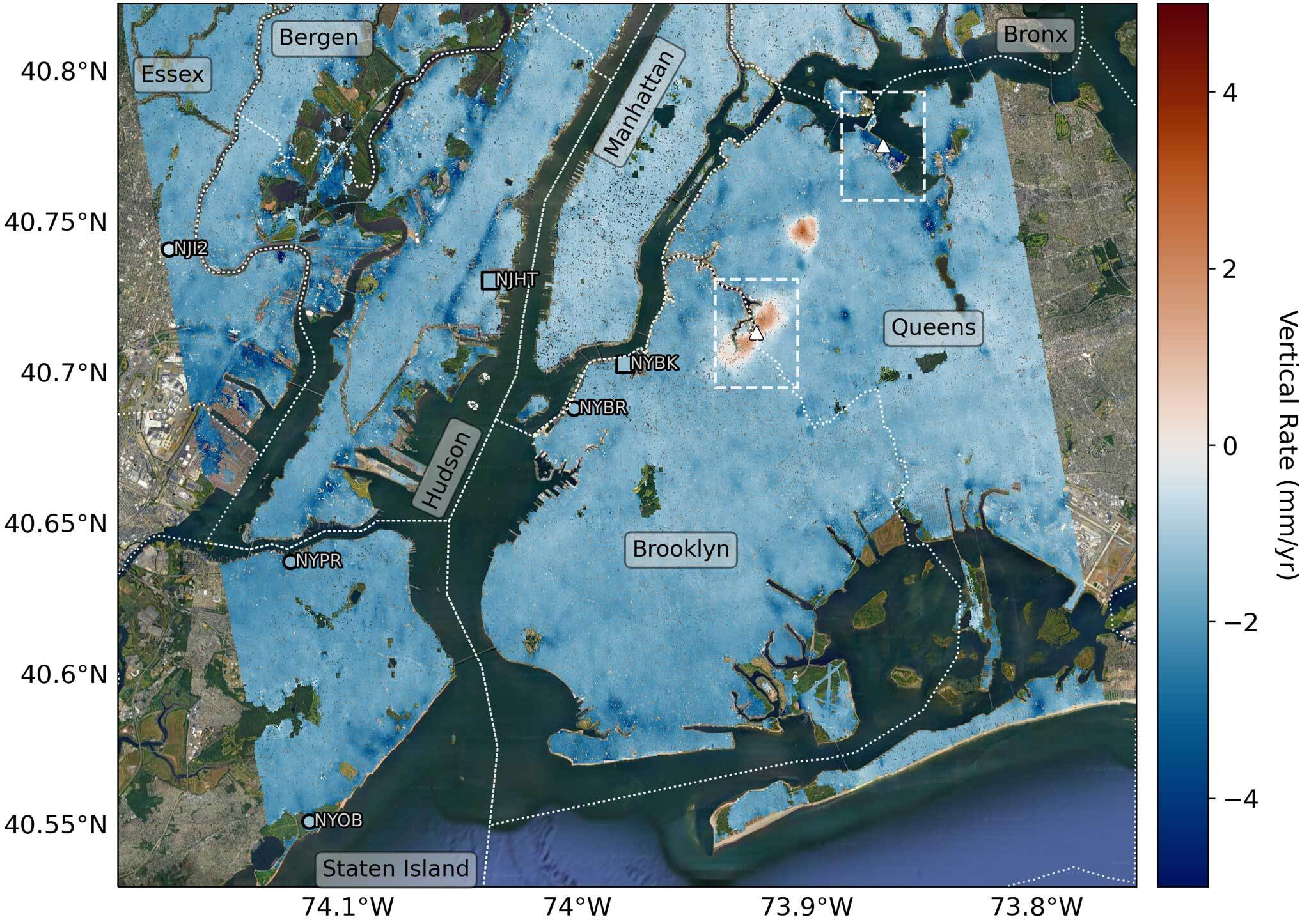
Between 2016 and 2023, researchers at NASA's Jet Propulsion Laboratory (JPL) used a space-based method known as interferometric synthetic aperture radar (InSAR) to 3D-map the ground beneath New York City, measuring vertical land motion over time. They found that during this period, the area sank an average of 0.06 inches (1.6 millimeters) per year.
Generally speaking, some of the land beneath New York is sinking naturally. Some 24,000 years ago, an ice sheet covered New England, and under its monumental weight, the land beneath sank down like a mattress depressing under the weight of a bowling ball. Meanwhile, areas around the ice sheet — including New York City — moved upward slightly to compensate. Now that the ice has melted, the land is reverting to its normal levels in a process called glacial isostatic adjustment. As for the city, that means the ground is sinking.
Related: Satellites watch as Hurricane Lee swirls towards Canada (video)
However, the team's research has unveiled new discoveries about New York's downward trajectory, and some of it isn't natural. Some of it has ties to human activity. "We’ve produced such a detailed map of vertical land motion in the New York City area that there are features popping out that haven’t been noticed before," Brett Buzzanga, a postdoctoral researcher at JPL who served as lead author on a paper about the study, said in a statement.
In Queens, for example, the land is sinking faster than average at LaGuardia Airport's runway 13/31 and Arthur Ashe Stadium, where the U.S. Open is held each year. That's because they're built on landfills. Governors Island and Rikers Island are other subsidence (or sinking) hotspots linked to landfills.
The team also discovered spots where the land is rising (also known as uplift). In East Williamsburg, Brooklyn, the land is moving upwards about 0.06 inches (1.6 millimeters) per year. And in Woodside, Queens, the land rose 0.27 inches (6.9 millimeters) per year between 2016 and 2019, though that movement has now stabilized. According to study co-author Robert Kopp of Rutgers University, groundwater pumping and injection wells could be a factor for this short-term uplift.
Breaking space news, the latest updates on rocket launches, skywatching events and more!
"I'm intrigued by the potential of using high-resolution InSAR to measure these kinds of relatively short-lived environmental modifications associated with uplift," said Kopp, noting that further investigation into Woodside is needed.
Upcoming studies will continue to investigate surface displacement across the globe, including the upcoming NASA-Indian Space Research Organization Synthetic Aperture Radar (NISAR) mission due to launch next year. With sea level rise occurring around the planet, this data could prove invaluable for planning.

Space.com contributing writer Stefanie Waldek is a self-taught space nerd and aviation geek who is passionate about all things spaceflight and astronomy. With a background in travel and design journalism, as well as a Bachelor of Arts degree from New York University, she specializes in the budding space tourism industry and Earth-based astrotourism. In her free time, you can find her watching rocket launches or looking up at the stars, wondering what is out there. Learn more about her work at www.stefaniewaldek.com.
