


The recent rumblings of a famously active Indonesian volcano are visible from space.
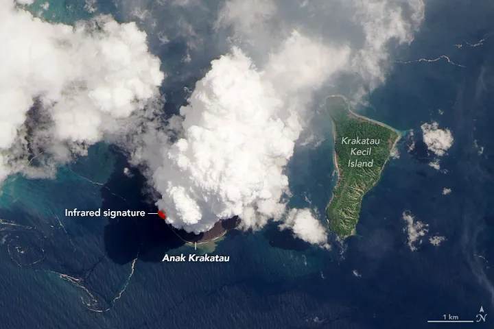
The Landsat 8 satellite, a joint effort of NASA and the U.S. Geological Survey, captured a striking photo on Monday (April 13) of Anak Krakatau's latest eruption, which has sent plumes of ash and water vapor billowing into the tropical skies and lava flows coursing into the surrounding turquoise waters.
The natural-color image is overlaid by infrared data gathered by one of Landsat 8's instruments. The infrared measurements highlight a hot spot that may be molten rock, NASA Earth Observatory's Kathryn Hansen wrote in a description of the photo.
Related: Amazing images of volcanoes from space

Anak Krakatau sits in the Sunda Strait between the big Indonesian islands of Java and Sumatra. The volcano's name translates as "child of Krakatau," and for good reason. In 1927, the island rose from the caldera created by the devastating 1883 eruption of Krakatau (also known as Krakatoa), which killed 36,000 people and darkened skies around the world for several years.
Anak Krakatau hasn't unleashed anything on that scale, thankfully. But the volcano has been quite active recently.
The volcano "has displayed these small eruptive bursts periodically through the last few years," Verity Flower, a volcanologist based at NASA's Goddard Space Flight Center in Greenbelt, Maryland, told Hansen. "However, it can also display more destructive activity such as tsunami-triggering eruptions."
One such eruption occurred on Dec. 22, 2018; the resulting tsunami killed hundreds of people.
- The 11 biggest volcanic eruptions in history
- Earth from space: Landsat satellites' 40-year legacy explained (infographic)
- The 10 most hazardous countries for volcanoes (photos)
Mike Wall is the author of "Out There" (Grand Central Publishing, 2018; illustrated by Karl Tate), a book about the search for alien life. Follow him on Twitter @michaeldwall. Follow us on Twitter @Spacedotcom or Facebook.

