A new map has provided the blueprints for the moon, revealing the true nature of Earth's rocky companion.
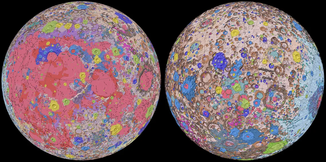
Scientists at the United States Geological Survey (USGS), in collaboration with NASA and the Lunar Planetary Institute, have created the first-ever comprehensive geologic map of the moon. In this new digital map, titled the "Unified Geologic Map of the Moon," the entire lunar surface has been thoroughly charted and all of its features uniformly classified.
You can find the map, which shows an incredible amount of detail at a 1:5,000,000 scale, online here.
This map details exactly what makes up the beautiful variety of dark and light spots on the moon's surface. It is intended not only as a scientific and educational tool, but it could also be invaluable for future crewed missions to the moon.
Video: New geologic moon map is most comprehensive ever
Related: Amazing moon photos from NASA's Lunar Reconnaissance Orbiter
"People have always been fascinated by the moon and when we might return," Jim Reilly, a former NASA astronaut and current director of the USGS, said in a statement. "So, it's wonderful to see USGS create a resource that can help NASA with their planning for future missions."
This new digital map is so comprehensive, in part, because it uses data spanning the last five decades. The collaborative team behind the map used data from recent satellite missions to the moon, as well as data collected and maps created during NASA's Apollo missions to and around the moon.
Among the recent data are elevation measurements from stereo observations made by the Terrain Camera on JAXA's SELENE (Selenological and Engineering Explorer) mission and topography data from the Lunar Orbiter Laser Altimeter (LOLA) instrument on NASA's Lunar Reconnaissance Orbiter.
"This map is a culmination of a decades-long project," Corey Fortezzo, USGS geologist and lead author on this work, said in the same statement. "It provides vital information for new scientific studies by connecting the exploration of specific sites on the moon with the rest of the lunar surface."
These scientists merged the old and new datasets and updated the Apollo-era maps with the more recent data. Additionally, they developed a new, unified method for describing the moon's rock layers. Previously, moon maps have used a variety of names for the different types of rock and rock layers, and this new unified description method absolved that inconsistency.
You can read an abstract describing the work on this map here, published by the USGS.
- Why is it so hard to land on the moon?
- Who will be the first woman on the moon?
- Lunar robotic mission Heracles will scout for human landings
Follow Chelsea Gohd on Twitter @chelsea_gohd. Follow us on Twitter @Spacedotcom and on Facebook.