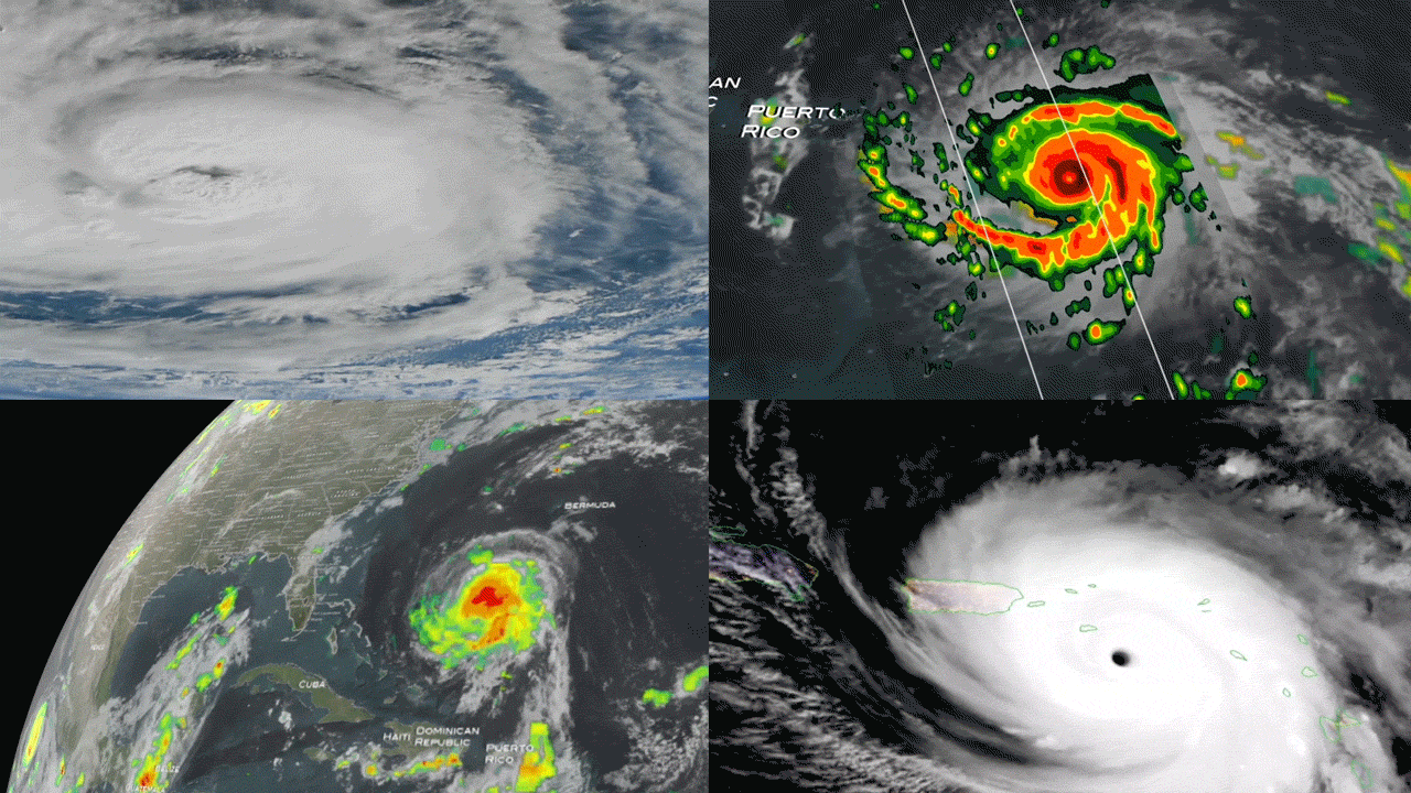
NASA satellites captured views of Hurricane Maria, Irma, Harvey and Jose as they rapidly intensified and barreled toward the Caribbean islands and the United States.
Rapid intensification occurs when hurricanes strengthen in a short period of time, making it the "hardest aspect of a storm to forecast," according to a statement from NASA's Goddard Space Flight Center.
Specifically, when a hurricane's maximum sustained winds increase at least 35 mph (56 km/h) in 24 hours, the storm is considered to have rapidly intensified. For example, Hurricane Maria developed from a Category 1 to a Category 5 hurricane in less than 18 hours, NASA officials said in the statement.
Not only is this type of storm harder to predict, but it is also considered to be the "most critical to people's lives," as there is a greater risk of damage caused by storm surges, floods and extreme winds, NASA officials said. Also, populations have limited time to prepare and evacuate, because these storms can grow so quickly, according to the statement.
"Rapidly intensifying storms typically occur up to twice in a hurricane season," NASA officials said in the statement. “But in 2017, we have seen four storms rapidly intensify and scientists attribute this to warmer ocean waters and favorable winds.”
Hurricanes Maria, Irma, Harvey and Jose were all categorized as major hurricanes — but only Harvey, Irma and Maria made landfall. One of the reasons these storms were so dangerous was because they rapidly intensified before moving inland. (Jose stayed offshore near the eastern United States, but still brought tropical storm force winds to Barbuda before changing course.)
"In the past few decades, forecasting errors for tracking hurricanes have decreased," according to a video from NASA's Goddard Space Flight Center. "While intensity forecast errors have shown recent improvement, significant errors can still occur because of rapidly intensifying storms."
Using NASA satellites, however, scientists can closely monitor hurricanes for signs of rapid intensification, including water temperature and wind patterns.
Generally, there needs to be low vertical wind shear — winds that don't change too much with altitude — and ocean temperatures need to be 80 degrees Fahrenheit or higher for a hurricane to rapidly intensify. Another key indicator is a symmetrical, deep ring of precipitation surrounding the eye of the storm, according to the NASA video.
However, the video also notes that these clues are not always a clear indication of rapid intensification, proving just how complex it can be to predict. Rather, there are also many small-scale processes that can influence the rate at which hurricanes grow and develop.
"Satellites such as NASA's Global Precipitation Measurement Mission can observe precipitation inside all of these storms and help scientists better understand how these processes come together to intensify hurricanes," according to the video.
Follow Samantha Mathewson @Sam_Ashley13. Follow us @Spacedotcom, Facebook and Google+. Original article on Space.com.